Small northern Ont. airport assisting MNRF with the forest fire situation
Hot, dry temperatures are not helping the current wildfire situation. There are currently 27 active forest fires burning in northeastern Ontario.
But through this time of scorch and flame, a small regional airport has been a key pit stop in helping helicopters refuel before they need to get back in the sky en route to fight these fires.
For weeks, the tarmac at the Earlton-Timiskaming Regional Airport has seen a lot of helicopter traffic.
“We do our best to accommodate them on the quick turns,” said airport manager James Smith.
“It’s been keeping us busy.”
Since early June, the small airport has been transformed into a Ministry of Natural Resources and Forestry (MNRF) basecamp and pit stop for helicopters to refuel and fight nearby fires, most notably Kirkland Lake 5 burning about 40 kilometres southwest of the airport.
The airport was to scheduled to welcome five helicopters – however, the number of blazes and because of how spread out many of them are, four other helicopters were deployed elsewhere – there are still a couple that come and go when assistance is required.
“I currently have a light-duty helicopter here that goes up in the early morning hours to identify hot areas,” said Smith.
This helicopter, Smith said, scans the area where the fire is. This gives afternoon crews targets where they need to drop water on the fire using what’s called a ‘bambi bucket’.
“We’re still getting helicopter traffic in the afternoons hitting hot spots. Last week, the fellas came back from a scan and they had 16 identified hot spots,” said Smith.
The MNRF is also using the airport to move equipment and crews. Some larger, fixed-wing aircraft have also landed for a quick pit-stop re-fuel before heading farther north to their destination. Smith said the airport is opening its doors to landing crew for cold drinks and for a cool place to rest while their aircraft is refueling.
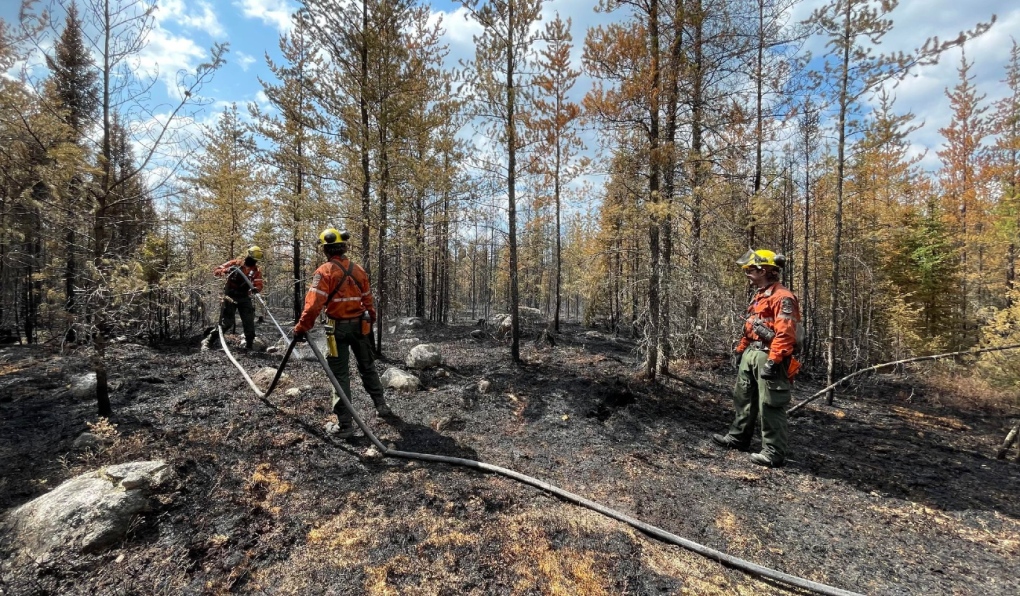 Firefighters fighting a forest fire in the northeast region. (Courtesy of Ministry of Natural Resources and Forestry)Smith said the airport is glad to be able to offer assistance.
“We’ve got 6,000 feet of asphalt here,” he said Smith.
“I can take anything the MNRF has to offer.”
The airport is no stranger to this kind of operation. In 2018, it played host to the ministry and many helicopters were stationed there to fight one large nearby forest fire.
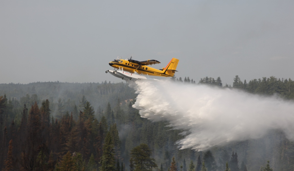 Four Twin Otter waterbombers and a lead birddog aircraft are conducted aerial fire suppression operations in the North Bay district of the northeast region on July 4/23. (Courtesy of Ministry of Natural Resources and Forestry)Of the active forest fires in the northeast region: three are not under control, five are being held, seven are under control and 12 are being observed.
“Essentially when a fire is an immediate threat to valleys, infrastructure, or people, they’ll receive a very quick response,” said MNRF fire information officer Isabelle Chenard.
The largest fire in the northeast region is still Cochrane 7, located north of Lake Abitibi near the Quebec border, which started June 2. It is still not under control, but has not grown in the last five days and remains at 37,742 ha.
When choosing which fires to tackle, the MNRF uses its Wildland Fire Management Strategy to assess each blaze based on risk, safety, suppression efforts, ecological benefits and available resources.
“Sometimes we have fires that are very, very intense. So we have to take an indirect approach to firefighting,” said Chenard.
“We’ll work to build control lines around the fire.”
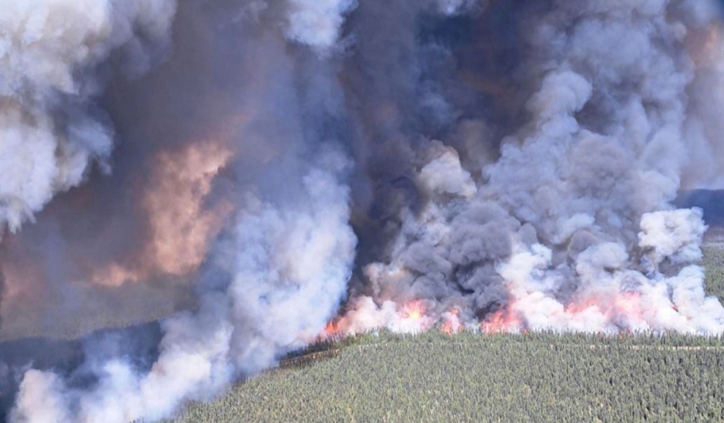 Aerial view of a forest fire in the northeast region. (File photo)There have more than 365 wildfires recorded since April 12th with more than 315,000 total ha burned.
The fire hazard varies from high to extreme throughout most of the northeast region. Areas southeast of Mattawa and generally south of Burk’s Falls are experiencing predominantly moderate to high fire hazard values.
For a closer look at fire hazard conditions in your area, view the ministry’s interactive map.
Shopping Trends
The Shopping Trends team is independent of the journalists at CTV News. We may earn a commission when you use our links to shop. Read about us.


CTVNews.ca Top Stories

Quebec fugitive killed in Mexican resort town, RCMP say
RCMP are confirming that a fugitive, Mathieu Belanger, wanted by Quebec provincial police has died in Mexico, in what local media are calling a murder.
Trump again calls to buy Greenland after eyeing Canada and the Panama Canal
First it was Canada, then the Panama Canal. Now, Donald Trump again wants Greenland. The president-elect is renewing unsuccessful calls he made during his first term for the U.S. to buy Greenland from Denmark, adding to the list of allied countries with which he's picking fights even before taking office.
Canada regulator sues Rogers for alleged misleading claims about data offering
Canada's antitrust regulator said on Monday it was suing Rogers Communications Inc, for allegedly misleading consumers about offering unlimited data under some phone plans.
Pioneering Métis human rights advocate Muriel Stanley Venne dies at 87
Muriel Stanley Venne, a trail-blazing Métis woman known for her Indigenous rights advocacy, has died at 87.
Bill Clinton hospitalized with a fever but in good spirits, spokesperson says
Former President Bill Clinton was admitted Monday to Georgetown University Medical Center in Washington after developing a fever.
Multiple OnlyFans accounts featured suspected child sex abuse, investigator reports
An experienced child exploitation investigator told Reuters he reported 26 accounts on the popular adults-only website OnlyFans to authorities, saying they appeared to contain sexual content featuring underage teen girls.
King Charles ends royal warrants for Ben & Jerry's owner Unilever and Cadbury chocolatiers
King Charles III has ended royal warrants for Cadbury and Unilever, which owns brands including Marmite and Ben & Jerry’s, in a blow to the household names.
Man faces murder charges in death of woman who was lit on fire in New York City subway
A man is facing murder charges in New York City for allegedly setting a woman on fire inside a subway train and then watching her die after she was engulfed in flames, police said Monday.
'Serious safety issues': Edmonton building where security guard was killed evacuated
An apartment building where a security guard was killed earlier this month is being evacuated.
Barrie
-

Several collisions reported along Highway 11 as driving conditions deteriorate
Highway 11 was closed briefly in Oro-Medonte on Monday afternoon as driving conditions deteriorated, causing multiple collisions.
-
Student charged, firearms seized after threats against school: police
Police say officers found several firearms during a search at a teen’s home after he allegedly made violent threats against a secondary school.
-
Single-vehicle crash in Springwater Twp.
One woman was taken to the hospital following a single-vehicle crash in Springwater Township.
Toronto
-
 DEVELOPING
DEVELOPING Parts of Ontario under snowfall warning Monday as holiday travellers hit the road
Holiday travellers and commuters could be in for a messy drive on Monday morning as a significant round of snowfall moves into the region. Here are live updates on the situation in Toronto.
-
Everything you need to know about what’s open on Christmas in the GTA
Here's what you need to know about what's open and closed in the GTA over the Christmas holidays.
-
Ottawa
-

Ottawa mayor speaks on transit funding, federal turmoil in year-end interview
Ottawa Mayor Mark Sutcliffe spoke with CTV News on a variety of issues, including transit, the city budget and political turmoil on Parliament Hill in a year-end interview.
-
SNOWFALL WARNING
SNOWFALL WARNING Pre-Christmas storm forecasted in Ottawa with up to 20 cm of snow tonight
Environment Canada has issued a snowfall warning for Ottawa and parts of eastern Ontario with a snowstorm in the forecast Monday afternoon and into the evening.
-
What's open and closed in Ottawa over the holidays
CTVNewsOttawa.ca takes a look at what's open and closed over the Christmas and New Year's holidays this year.
Kitchener
-

Parts of southern Ontario under travel advisory
Anyone planning to travel today is being urged to be prepared as 5 to 15 cm of snow could hit a large portion of southern Ontario.
-
Beloved bookstore in Uptown Waterloo forced to close for months following fire
A beloved bookstore in Uptown Waterloo is bearing the brunt of some holiday misfortune.
-
Must-see moments of 2024: A superstar surprise, roundabout resident and CKCO studios come down
From a WWE surprise for a Guelph superfan, to the recovery of a lost aviation artifact, to a reporter getting the story right from the goose's mouth, here are some of our can’t-miss moments from 2024.
London
-

91-year-old harness driver victorious at The Raceway in London, Ont.
A 91-year-old harness driver raced his way to victory on Friday night with his horse, Willy Strike.
-
SIU concludes LPS was justified in striking a man in August arrest
Following an incident in August, the province’s police watchdog has concluded that a London Police Service officer did not commit a criminal offense.
-
Anonymous $2 million donation given to St. Joseph’s Health Care
St. Joseph’s Health Care Foundation has received an anonymous $2 million donation from a local community member.
Windsor
-

Restaurant staff aid in rescue of two men that fell into the frigid waters of the Detroit River
Windsor police say that shortly before 9:00 p.m. on Dec. 20, officers were called after a man fell into the water while standing too close to the marina wall. A second man jumped in to help him.
-
Child luring investigation sees Windsor resident charged
According to Essex OPP, 45-year-old Sean Oulette is facing charges of luring a person under 16 years of age by means of telecommunication.
-
'I’d rather be ahead than behind': Windsor's acute care hospital project ahead of schedule
The highly anticipated acute care hospital project is officially ahead of schedule, which means shovels could hit the ground sooner than expected.
Montreal
-
Quebec fugitive killed in Mexican resort town, RCMP say
RCMP are confirming that a fugitive, Mathieu Belanger, wanted by Quebec provincial police has died in Mexico, in what local media are calling a murder.
-
Guzzo Group says it wants to protect its 500 employees
Although the Guzzo Group is currently in turmoil, it is reassuring its employees and customers about the year ahead.
-
Snow on the way as Montreal is put under weather advisory
A weather advisory has been initiated for the Greater Montreal area, with 10 to 15 cm of snow expected to hit the ground.
Winnipeg
-

An alleged sniper, pair of animal claims featured on MPI’s top five fraud list for 2024
From hitting animals that weren’t there to a sniper that didn’t exist, Manitoba Public Insurance has released its top five frauds of 2024.
-
Manitoba government to make permanent cut to gas tax
Manitobans can expect to see a permanent change at the gas pump as early as next week
-
Snowmobile crash leaves 10-year-old dead: RCMP
A 10-year-old boy is dead following a snowmobile crash near Rosebank, Man., on Sunday.
Atlantic
-

Court of appeal certifies class action lawsuit against health authority, former nurse
A New Brunswick mother who is the lead plaintiff in a court case has received an early Christmas gift after the province’s top court certified her class-action lawsuit.
-
No need to dream, White Christmas all but assured in the Maritimes
An early nor'easter followed by a low-pressure system moving into the region all but ensure a Maritime White Christmas
-
Man and woman from New Canada charged for impaired driving: N.S. RCMP
Lunenberg District RCMP has charged a man and a woman, both from New Canada, N.S., with impaired driving.
N.L.
-

A massive, menacing Steller's sea eagle is dazzling birders in a Newfoundland park
A national park in Newfoundland has made the unusual move of opening in the winter so people can catch a glimpse of its rare and menacing new guest.
-
Newfoundland woman washed sick patients' hair every Saturday for more than 20 years
A retired nurse and teacher in Newfoundland was honoured this week for her volunteer work, which included more than two decades washing the hair of bedridden hospital patients.
-
Newfoundland man facing more charges related to youth sex crimes
A 64-year-old Newfoundland man charged with dozens of sex crimes involving young people is facing several new charges.
Calgary
-

Low Canadian dollar a 'double-edged sword' as more Americans travel north: economist
A Calgary economist says the low Canadian dollar is a mixed blessing, with data showing that more Americans are travelling north to make the most of their spending.
-
Taxpayers Federation unveils its annual spending 'Naughty and Nice List'
A media president and the Prime Minister have topped the Canadian Taxpayers Federation’s annual 'Taxpayer Naughty List' for 2024.
-
Roughriders acquire quarterback Maier's rights from Stampeders for '25 draft pick
The Saskatchewan Roughriders acquired the rights to veteran quarterback Jake Maier from the Calgary Stampeders on Monday for a 2025 eighth-round draft pick.
Edmonton
-

'Serious safety issues': Edmonton building where security guard was killed evacuated
An apartment building where a security guard was killed earlier this month is being evacuated.
-
City of Edmonton to lift Phase 1 parking ban Monday evening
The City of Edmonton will lift the Phase 1 parking ban on Monday at 5 p.m.
-
2 Alberta men charged with sex crimes involving children in separate investigations
Two registered sex offenders are facing charges after separate investigations in northern Alberta.
Regina
-

Estevan police officer arrested following SIRT investigation
An officer of the Estevan Police Service (EPS) is facing several charges following an investigation by the province’s police oversight agency.
-
Heavy fog descends over Regina, most of Saskatchewan
Dense fog is being reported across much of the province to begin the week of Christmas, according to Environment and Climate Change Canada (ECCC).
-
Riders acquire quarterback Jake Maier in trade with Stampeders
The Green and White finalized some Christmas shopping ahead of the holidays, acquiring quarterback Jake Maier in a trade with Calgary on Monday.
Saskatoon
-

'There are lines': In year-end interview, NDP leader says Moe went too far in election campaign
Saskatchewan’s two main political leaders had agreed before October's provincial election not to target the families of candidates during the campaign, says Opposition NDP Leader Carla Beck.
-
Sask. RCMP on the scene of rollover on Highway 40
The Saskatchewan RCMP said Highway 40 was closed Monday afternoon following a rollover just west of Hafford, a village just under 100 kilometres northwest of Saskatoon.
-
Saskatoon woman arrested following machete attack
A 55-year-old woman was arrested following a stabbing with a machete early Monday morning.
Vancouver
-

Cleanup underway after rockslide derails train in B.C.
No injuries were reported after a rockslide derailed a freight train, sending railcars into British Columbia's Fraser River, on Sunday night.
-
Stolen vehicle leads to wanted suspect carrying loaded gun, drugs: Kelowna RCMP
A stolen vehicle recently led Kelowna RCMP officers to a wanted suspect carrying a loaded gun and a "substantial" amount of drugs, according to their detachment.
-
1 person in critical condition after crash in New Westminster, B.C.
One person was taken to hospital in critical condition Monday after a crash involving a flatbed truck in New Westminster, B.C.
Vancouver Island
-
Cleanup underway after rockslide derails train in B.C.
No injuries were reported after a rockslide derailed a freight train, sending railcars into British Columbia's Fraser River, on Sunday night.
-
1 person in critical condition after crash in New Westminster, B.C.
One person was taken to hospital in critical condition Monday after a crash involving a flatbed truck in New Westminster, B.C.
-
More than 280M trees planted in 2024 in B.C., focus on fire-damaged areas
British Columbia's forests ministry says more than 280 million trees were planted in the province this year.


