Up to 14 cm of more snow for parts of the northeast
The winter weather travel advisory continues for much of the northeast Thursday following a blast of snow that brought as much as 15 cm to some areas, with up to 14 cm more to come.
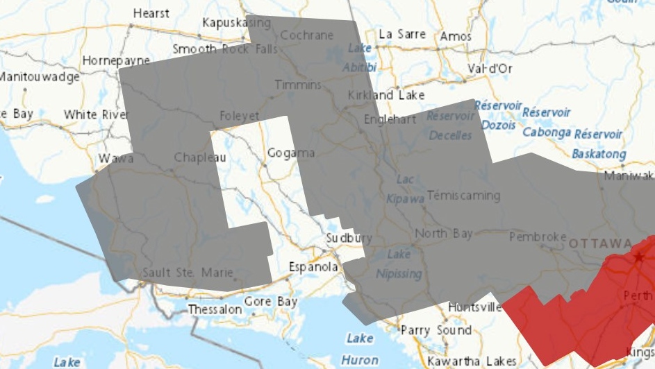 Weather alert map for Nov.9.23 (Environment Canada)
"Lake-enhanced flurries will develop Thursday morning. Local snowfall amounts of 7 to 14 centimetres are possible by this evening," Environment Canada said in a weather alert.
"Areas close (to) the shore of Lake Superior will receive a mix of rain and snow and as a result, snowfall amounts will be less."
The following communities are affected:
- Agawa
- Batchawana BayChapleau
- Cochrane
- Elliot Lake
- Iroquois Falls
- Kirkland Lake
- Lake Superior Park
- Missinaibi Lake
- Montreal River Harbour
- North Bay
- Ranger Lake
- Searchmont
- Temagami
- Temiskaming Shores
- Timmins
- West Nipissing
"Consider postponing non-essential travel until conditions improve," the weather alert said.
- Download the CTV News app now and get local alerts on your device
- Get local breaking news and updates sent to your email inbox
"Motorists should expect hazardous winter driving conditions and adjust travel plans accordingly. Surfaces such as highways, roads, walkways and parking lots may become difficult to navigate due to accumulating snow."
South of North Bay, the Burk's Falls - Bayfield Inlet area is expected to get an additional two to four cm of snow Thursday morning followed by a risk of freezing drizzle as temperatures rise.
Top Stories
-
-
 HAPPENING NOW
HAPPENING NOW Highway 400 traffic snarled in both directions after collision
-
-
-
-
-
-


CTVNews.ca Top Stories

Canadian flights, hospitals, border disrupted during global technology outage
A global technology outage grounded flights, disrupted hospitals and backed up border crossings in Canada on Friday, as issues persisted hours after problems with Microsoft services were said to be getting fixed.
LIVE UPDATES
LIVE UPDATES Here's the latest on Canadian impacts of the global IT outage
The latest developments on the Canadian impacts of the global technology outage that is causing massive disruptions to companies and services around the world.
BREAKING
BREAKING LCBO reaches tentative agreement to end strike, stores could reopen Tuesday
The LCBO has reached a tentative agreement with the union representing approximately 10,000 of its employees, paving the way for stores to reopen as early as Tuesday.
'Do not use homemade sunscreen,' Health Canada warns
Health Canada warned the public in an official statement Friday against homemade sunscreen after viral posts showed social media influencers creating recipes for SPF.
opinion
opinion Trump's assassination attempt not a political winner
Danger and fear are so pervasive throughout the national political ethos it is now the norm, writes Washington political columnist Eric Ham.
Saskatchewan Party nominee Meghan Mayer withdraws, apologizes for putting child in blackface
A former Saskatchewan Party nominee has apologized for putting a student in blackface.
Ontario woman says she was sold 'crumbling' house despite home inspection
As an Ontario woman put away her China dishes after Christmas Dinner in 2018, she noticed her cabinet doors refused to shut.
Cape Breton moose hunting suspended for 3 years due to 'significant' drop in population
Nova Scotia is suspending the licensed Cape Breton moose hunt for three years due to what the province is calling a “significant drop” in the population.
Canadian families will receive more in their next Canada Child Benefit payment. Here's why
Canadian families receiving Canada Child Benefit program payments can expect more cash in their cheques this Friday.
Shopping Trends
The Shopping Trends team is independent of the journalists at CTV News. We may earn a commission when you use our links to shop. Read about us.


Barrie
-
HAPPENING NOW
HAPPENING NOW Highway 400 traffic snarled in both directions after collision
Traffic south of Barrie along Highway 400 is at a standstill in both directions on Friday because of a collision.
-
Deadly motorcycle crash in Newmarket under investigation
Investigators are appealing to witnesses of a deadly collision involving a motorcycle and SUV in Newmarket.
-
Driver seriously injured after tanker rollover
Police closed a section of County Road 16 in Waubaushene on Friday after a tanker truck collision.
Toronto
-
 BREAKING
BREAKING LCBO reaches tentative agreement to end strike, stores could reopen Tuesday
The LCBO has reached a tentative agreement with the union representing approximately 10,000 of its employees, paving the way for stores to reopen as early as Tuesday.
-
Global IT outage having widespread impacts in Toronto. Here is the latest
A global technology outage impacting businesses around the world has led to flight cancellations in Toronto this morning, with Porter Airlines grounding all flights until 3 p.m.
-
This is the list of disruptions in Toronto due to the global IT outage
A global technology outage impacting businesses around the world has led to major disruptions in the GTA and other parts of Ontario.
Ottawa
-
 BREAKING
BREAKING Global IT outage affects flights, hospitals in Ottawa
A global technology outage grounded flights and impacted services at hospitals Friday morning in Ottawa.
-
BREAKING
BREAKING LCBO reaches tentative agreement to end strike, stores could reopen Tuesday
The LCBO has reached a tentative agreement with the union representing approximately 10,000 of its employees, paving the way for stores to reopen as early as Tuesday.
-
'We are in crisis': ByWard Market retailers, residents want City of Ottawa to address safety, revitalization concerns
Retailers and residents in the ByWard Market are calling on Mayor Mark Sutcliffe and the City of Ottawa to take immediate steps to revitalize and improve safety in the popular Ottawa tourist area.
Kitchener
-
BREAKING
BREAKING LCBO reaches tentative agreement to end strike, stores could reopen Tuesday
The LCBO has reached a tentative agreement with the union representing approximately 10,000 of its employees, paving the way for stores to reopen as early as Tuesday.
-
How the global tech outage is affecting Waterloo Region, Guelph and Brant
The local impact of Friday's global technology outage.
-
Some delays possible as local hospitals impacted by global IT outage
Some services in Waterloo region are feeling the string of a global IT outage affecting Mircosoft programs.
London
-

London victim of intimate partner violence dies in hospital
A 17-year-old girl has succumbed to injuries she suffered during a stabbing earlier this week. Emergency responders were called to Wellesley Crescent late Tuesday night after two people were stabbed by a man.
-
Most London-area organizations and businesses not impacted by global IT outage
It appears most public institutions and agencies in the London region are not feeling the effects of the global cyber interruptions, but there are some exceptions.
-
BREAKING
BREAKING LCBO reaches tentative agreement to end strike, stores could reopen Tuesday
The LCBO has reached a tentative agreement with the union representing approximately 10,000 of its employees, paving the way for stores to reopen as early as Tuesday.
Windsor
-
BREAKING
BREAKING LCBO reaches tentative agreement to end strike, stores could reopen Tuesday
The LCBO has reached a tentative agreement with the union representing approximately 10,000 of its employees, paving the way for stores to reopen as early as Tuesday.
-
Third suspect arrested in connection to Walkerville robbery
The third suspect wanted in connection to a Walkerville robbery has been arrested.
-
Off-duty Windsor police officer charged with failing to provide breath sample
Windsor police say an off-duty officer has been charged after refusing to provide a breath sample during a traffic stop.
Montreal
-

Five things to know about Quebec's unique, two-week-long construction holiday
It's one of Quebec's many idiosyncrasies that in the dog days of summer, when everyone wishes they were on holiday, virtually the entire construction industry and a good chunk of the rest of the province close up shop for two weeks.
-
Flights at Montreal's Trudeau Airport affected by global IT outage
Some airlines at Montreal's Pierre Elliott Trudeau International Airport are being affected by a global technology outage.
-
Man, 65, struck by vehicle while crossing Montreal street
A 65-year-old man is recovering in hospital after he was struck by a vehicle crossing the street in Montreal on Friday morning.
Winnipeg
-

Manitoba companies impacted by global IT outage
A global information technology outage is causing disruptions in Manitoba.
-
Zebra mussel containment coming to Clear Lake
Parks Canada said more evidence of zebra mussels has been found in a Manitoba lake.
-
'Powerful symbol of the progress we have made': Land being returned to Manitoba Métis Federation
Around 100 acres of Manitoba Crown Land near the Saskatchewan border is being returned to the Métis community.
Atlantic
-

Emergency crews on scene of plane crash near Fredericton
The New Brunswick RCMP and Keswick Valley Fire Department are on the scene of a small plane crash near Burtts Corner, N.B., about 22 kilometres west of Fredericton.
-
Newfoundland town on edge as crews search for missing vessel with 7 people aboard
Anxiety gripped a Newfoundland fishing community Friday as a massive search was underway for a missing vessel carrying seven harvesters that hadn't been heard from in two days.
-
Man, 33, charged with stunting after vehicle's speed clocked at 50 km/h over limit: Halifax Regional Police
A 33-year-old man is facing a stunting charge after police say he was driving 160 km/h in a 110 km/h speed zone.
N.L.
-

Newfoundland town on edge as crews search for missing vessel with 7 people aboard
Anxiety gripped a Newfoundland fishing community Friday as a massive search was underway for a missing vessel carrying seven harvesters that hadn't been heard from in two days.
-
Ground assault begins on Labrador City wildfire that forced thousands to evacuate
Firefighters began attacking a fire near Labrador City from the ground today, marking a new stage in the effort to get the roaring wildfire under control.
-
Get it while you can, fish harvesters say, handing out free cod in downtown St. John's
The latest protest against Ottawa's decision to reopen a commercial cod fishery drew a good line in downtown St. John's
Calgary
-

Global technology outage grounds flights, disrupts services in Calgary
A small number of flights leaving Calgary have been impacted by a technology outage that's causing widespread concern around the world.
-
Smell smoke? Calgary's air quality 'moderate' for start of weekend
Calgary's air quality is expected to be somewhat poor for the start of the weekend.
-
Lethbridge police concerned about 'bait-and-switch tactic' on social media
Lethbridge police are warning the public over what they're calling a "bait-and-switch tactic" being used by scammers who are posting on social media about phony alerts about missing children, seniors and pets.
Edmonton
-

Out-of-control wildfire forces evacuation of northern Alberta community
Chipewyan Lake in northern Alberta was evacuated Thursday night as an out-of-control wildfire burned toward the community.
-
Josh Classen's forecast: Smoke moves in as heat wave rolls on
A heat warning remains in effect for Edmonton and almost all of Alberta. Temperatures will soar into the low to mid 30s across most of the province, again.
-
Search and rescue underway after 2 people lost in western Alberta river: RCMP
Two people remained missing Friday morning more than 12 hours after they were lost in the Smoky River in west-central Alberta.
Regina
-

'Pink Friday': Family of Bella Brave encourages people to wear pink in her honour
The family of Isabella “Bella Brave” Thomson is encouraging people to wear pink in her honour on Friday.
-
Investigators deployed to 'aircraft accident' in southwest Sask.
An aircraft accident occurred early Friday morning near Birsay, Saskatchewan, according to the Transportation Safety Board of Canada (TSB).
-
Saskatchewan Party nominee Meghan Mayer withdraws, apologizes for putting child in blackface
A former Saskatchewan Party nominee has apologized for putting a student in blackface.
Saskatoon
-

Saskatchewan Party nominee Meghan Mayer withdraws, apologizes for putting child in blackface
A former Saskatchewan Party nominee has apologized for putting a student in blackface.
-
Saskatoon Transit riders, Healthline 811 affected by global Microsoft outage
Saskatoon residents who ride the bus are being impacted by the nation-wide technology outage affecting Microsoft apps and services on Friday.
-
Sask. woman charged in fatal THC-driving case had Charter rights violated, defence says
The lawyer representing a woman who struck and killed a child while driving says a number of her Charter rights were violated.
Vancouver
-

B.C. hospitals, health services affected by global IT outage
B.C. Health Minister Adrian Dix said the outage affected approximately 50,000 electronic devices across the health ministry, including 30,000 on the B.C. mainland and another 20,000 on Vancouver Island.
-
Some flights at Vancouver airport impacted by global technology outage
A number of scheduled flights at the Vancouver airport have been affected by the massive technology outage causing disruptions at companies and services around the world.
-
Wildfire near Spences Bridge, B.C., explodes in size overnight as heat wave continues
The out-of-control Shetland Creek fire in British Columbia's southern Interior has more than doubled in size due to what the wildfire service describes as "significant overnight growth" and more accurate mapping.
Vancouver Island
-
B.C. hospitals, health services affected by global IT outage
B.C. Health Minister Adrian Dix said the outage affected approximately 50,000 electronic devices across the health ministry, including 30,000 on the B.C. mainland and another 20,000 on Vancouver Island.
-
Wildfire near Spences Bridge, B.C., explodes in size overnight as heat wave continues
The out-of-control Shetland Creek fire in British Columbia's southern Interior has more than doubled in size due to what the wildfire service describes as "significant overnight growth" and more accurate mapping.
-
Some flights at Vancouver airport impacted by global technology outage
A number of scheduled flights at the Vancouver airport have been affected by the massive technology outage causing disruptions at companies and services around the world.


