Winter weather travel advisory in effect, up to 15 cm of snow
Snow will be falling in northeastern Ontario on Wednesday afternoon due to an approaching low-pressure system that will bring up to 15 cm by Thursday morning.
The snow is expected to be heavy at times causing poor visibility from the Superior East region to North Bay so Environment Canada issued a winter weather travel advisory.
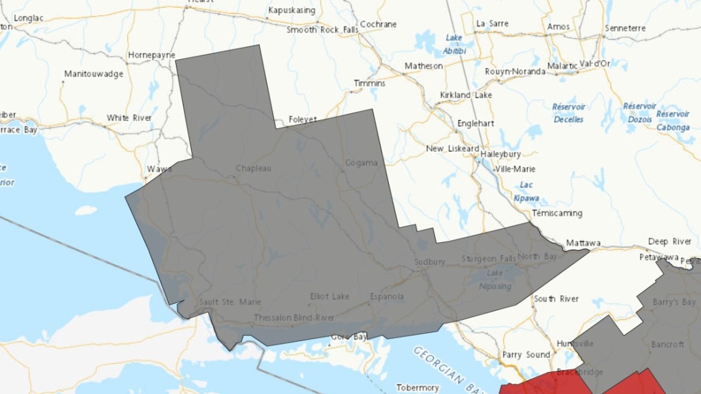 Winter weather travel advisory issued in the northeast. Nov. 8/23 (Environment Canada)
"Consider postponing non-essential travel until conditions improve. Motorists should expect hazardous winter driving conditions and adjust travel plans accordingly," the weather alert said at 9:45 a.m.
"Surfaces such as highways, roads, walkways and parking lots may become difficult to navigate due to accumulating snow."
Communities affected by the weather advisory are:
- Agawa
- Batchawana Bay
- Blind River
- Chapleau
- Elliot Lake
- Espanola
- Foleyet
- Gogama
- Greater Sudbury and vicinity
- Killarney
- Lake Superior Park
- Missinaibi Lake
- Montreal River Harbour
- North Bay
- Ranger Lake
- St. Joseph Island
- Sault Ste. Marie
- Searchmont
- Thessalon
- West Nipissing
The snow will taper off to light flurries by Thursday morning.
An additional five to 10 cm is expected in the area east of Lake Superior on Friday.
Top Stories
-
-
 WATCH LIVE @ 3:30 P.M.
WATCH LIVE @ 3:30 P.M. Video shows person break into Old Montreal building before fatal fire that killed mother, daughter
-
-
-
-
-
-


CTVNews.ca Top Stories

'I screamed in shock and horror': Family faces deadly Vancouver hit-and-run driver during sentencing
The sentencing of the man who pleaded guilty in the deadly hit-and-run in Kitsilano two years ago began on Friday.
Tropical Storm Milton forms in Gulf of Mexico, could intensify as a hurricane threatening Florida
Tropical Storm Milton has formed in the Gulf of Mexico. It is located 220 miles (355 kilometres) north-northeast of Veracruz, Mexico.
WATCH LIVE @ 3:30 P.M.
WATCH LIVE @ 3:30 P.M. Video shows person break into Old Montreal building before fatal fire that killed mother, daughter
The two people who died in a major fire in Old Montreal on Friday were a mother and her seven-year-old daughter, sources told Noovo Info.
Frequent drinking of fizzy beverages and fruit juice are linked to an increased risk of stroke: research
New data raises questions about the drinks people consume and the potential risks associated with them, according to researchers at Galway University in Ireland, in partnership with Hamilton’s McMaster University.
Northwestern Ont. woman charged with arson with disregard for human life
A 30-year-old northwestern Ontario woman has been charged with arson following a structure fire Thursday night, police say.
OPP charge driver going 175 km/h on Highway 417 in Ottawa
Ontario Provincial Police have laid stunt charges against a driver caught speeding 75 km/h over the speed limit on Highway 417 in Ottawa's west end.
Looking for cheap flights for the holidays? Here are some tips to remember
Travelling on a budget can be stressful, but there are ways you can ensure you're getting the best deal on flights as the holiday season approaches.
A French judge in a shocking rape case allows the public to see some of the video evidence
A French judge in the trial of dozens of men accused of raping an unconscious woman whose now former husband had repeatedly drugged her so that he and others could assault her decided on Friday to allow the public to see some of the video recordings of the alleged rapes.
The Menendez brothers case is not the only one that's been affected by a true crime documentary
Being an armchair detective has turned into an American obsession, fueled by an abundance of true-crime content in podcasts and television series. But some of those projects have sparked actual legal developments.
Shopping Trends
The Shopping Trends team is independent of the journalists at CTV News. We may earn a commission when you use our links to shop. Read about us.


Barrie
-

Drug trafficking investigation leads to seizure of weapons and stolen property: OPP
Three people from Simcoe County face charges in relation to a drug trafficking investigation that police say resulted in the seizure of several weapons, drugs and thousands of dollars worth of stolen property.
-
OPP investigating slew of drug busts, impaired driving incidents
The Southern Georgian Bay OPP Detachment is investigating several impaired driving incidents that occurred over the past week, including two that led to drug busts.
-
Man arrested for alleged assault, death threats at local business
A man is facing multiple charges after reportedly threatening to harm staff members at an Orillia business Friday afternoon.
Toronto
-

Officer arrested after allegedly stealing alcohol from store: TPS
A Toronto police officer has been arrested after allegedly stealing three bottles of alcohol from a store.
-
Two pedestrians taken to hospital after Vaughan crash, one person in custody
Two pedestrians have been taken to hospital with serious injuries after an early-morning collision in Vaughan.
-
Nuit Blanche takes over Toronto tonight. Here is what you need to know about road closures and TTC service
Toronto’s annual Nuit Blanche is back and with it come road closures.
Ottawa
-

Frost advisory issued with temperatures expected to drop near freezing in Ottawa
Environment Canada has issued a frost advisory as temperatures across Ottawa and eastern Ontario are expected to dip near the freezing mark this evening.
-
This Ottawa photo radar camera issued 200 tickets a day over the summer
New data shows the automated speed enforcement camera on King Edward Avenue, between Bolton Street and St. Patrick Street, issued 6,337 speeding tickets in August, the highest number of tickets issued by Ottawa's 40 photo radar cameras.
-
OPP charge driver going 175 km/h on Highway 417 in Ottawa
Ontario Provincial Police have laid stunt charges against a driver caught speeding 75 km/h over the speed limit on Highway 417 in Ottawa's west end.
Kitchener
-

1 suffers 'minor injury' after small plane crash lands in Brussels
The Huron Ontario Provincial Police said they responded to a “downed airplane” just after 11 a.m. Saturday.
-
1 person sprayed with 'noxious substance' in Cambridge
Police say they were called to the area of Simcoe Street and Market Street around 1:30 a.m. Saturday for a report of an assault.
-
Impaired driver charged after car crashes in Kitchener home: WRPS
Police have laid charges after a car crashed into the side of a Kitchener home early Friday morning.
London
-

One injured in plane crash near Brussels
Huron OPP say they were on the scene of a plane crash this morning, with a pilot finding themselves unable to halt before the end of a runway in Brussels.
-
'Panther Day'; St. Thomas celebrates growing girls hockey association
The St. Thomas Panthers organization held ‘Panther Day’ focusing on recognizing IIAF World Girls Hockey weekend.
-
Tax rebate: Canadians with low to modest incomes to receive payment
Canadians who are eligible for a GST/HST tax credit can expect their final payment of the year on Friday.
Windsor
-

Leamington business and property owners fined $10,000 for fire code violations
The municipality issued a stern reminder for code violators, as both were fined following a warning issued by Leamington Fire Services.
-
Man wanted for vandalism in Windsor
According to police, the suspect entered and vandalized the property in the 700 block of Grand Marais Road Easton on September 28.
-
Looking for cheap flights for the holidays? Here are some tips to remember
Travelling on a budget can be stressful, but there are ways you can ensure you're getting the best deal on flights as the holiday season approaches.
Montreal
-
WATCH LIVE @ 3:30 P.M.
WATCH LIVE @ 3:30 P.M. Video shows person break into Old Montreal building before fatal fire that killed mother, daughter
The two people who died in a major fire in Old Montreal on Friday were a mother and her seven-year-old daughter, sources told Noovo Info.
-
Police boosting presence in Montreal ahead of Oct. 7 anniversary of Israel-Hamas war
Montreal police say they are increasing their presence across the city ahead of the one-year anniversary of the Oct. 7 start of the Israel-Hamas war.
-
Montreal business hit with Molotov cocktail 2 nights in a row: police
Montreal police say a business in the city's Pointe-Saint-Charles neighbourhood was hit with Molotov cocktails two nights in a row.
Winnipeg
-

'Great fun in this': Giant roadside attractions across Manitoba highlighted online
It’s 1998. Google was just born, and dial-up was the primary way to connect to the Internet. New sites were being developed daily on any number of topics, from recipes to shopping. David Yanciw, however, was thinking big - big things, that is.
-
Glenwood house under construction set ablaze Saturday
A two-storey house that was under construction was the scene of a Saturday morning fire in Winnipeg’s Glenwood neighbourhood.
-
STARS, emergency crews dispatched to crash on Highway 12 in Brokenhead
Highway 12 has been reopened following a single motor vehicle collision Saturday morning in the RM of Brokenhead, Man.
Atlantic
-

Battle between activist candidate and ex-Tory reflects schism in N.B. politics
A riding in southwest New Brunswick that for decades was a Progressive Conservative stronghold is shaping up to be a bellwether that could offer a window into the future of the Tory party, and maybe of the province.
-
Tropical Storm Milton forms in Gulf of Mexico, could intensify as a hurricane threatening Florida
Tropical Storm Milton has formed in the Gulf of Mexico. It is located 220 miles (355 kilometres) north-northeast of Veracruz, Mexico.
-
Latest book from Nova Scotia author Allison Maher is a surprising first entry into adult fiction
Nova Scotia author Allison Maher made the jump from young adult (YA) to adult fiction with her most recent novel, “The Last of the Firsts” and the response from readers has been a surprise for the writer.
N.L.
-

Marathon goat: Animal runner wins hearts and a medal after crashing Newfoundland race
He may not have logged the fastest time or even gone the full distance, but residents of a Newfoundland town agree the goat who unexpectedly joined the local weekend half marathon was the event's undisputed champion.
-
Labrador residents say 'inhumane' food prices force families to go hungry
A mother in a community where the cost of living is one of the highest in the country says grocery prices are 'inhumane' and retailers are putting profits ahead of people’s basic human right to food.
-
Small English soccer team has huge year, thanks in part to Newfoundland and Labrador
A soccer game in England on Tuesday night drove a spike in online traffic across the Atlantic to a website launched by the Newfoundland and Labrador government.
Calgary
-

Turner Valley RCMP on scene at vehicle rollover near Plummers Road
An investigation is underway into what caused a vehicle rollover Saturday in the area of Plummers Road and Priddis Valley Road.
-
Pedestrian struck by vehicle in southeast Calgary
A pedestrian is in critical condition after being struck by a vehicle in southeast Calgary on Friday night.
-
Lethbridge police seize fentanyl, weapons, stolen vehicle in downtown enforcement project
Lethbridge police executed dozens of warrants and laid numerous charges in another targeted enforcement project in the downtown area.
Edmonton
-

'We're losing billion of birds': Backyard risks to Alberta's birds and how you can help make fall migration a successful one
An estimated four billion birds will navigate man-made environments as they travel south from North America during fall migration. Tens of million of them will die en route due to human-created hazards.
-
Woman dies in east Edmonton collision with building on 118 Avenue
A 79-year-old woman is dead after the vehicle she was driving crashed into an east Edmonton building late Friday afternoon.
-
Goaltender Jack Campbell enters NHL/NHLPA player assistance program
Detroit Red Wings goaltender Jack Campbell has entered the NHL/NHLPA player assistance program.
Regina
-

Wind warning in effect as strong gusts hammer Regina, southern Sask.
A wind warning has been issued for parts of southern Saskatchewan, with gusts of up to 100 kilometres per hour (km/h) possible in some areas on Saturday, Environment and Climate Change Canada says.
-
Regina police investigating after multiple homes shot at during overnight hours
Regina police are investigating after guns were fired at two homes last week, with one home being shot at on multiple occasions.
-
Sask. community marks sod-turning for Humboldt Broncos memorial
A permanent memorial at the site of the 2018 Humboldt Broncos bus crash is about to be a step closer.
Saskatoon
-

Sask. community marks sod-turning for Humboldt Broncos memorial
A permanent memorial at the site of the 2018 Humboldt Broncos bus crash is about to be a step closer.
-
Private school funding draws attention during STF education forum
The Saskatchewan Teachers' Federation hosted a virtual election forum on education Thursday evening, giving candidates in the provincial election a chance to share their thoughts and answer questions on issues teachers find most important.
-
Sask. man pleads guilty in U.S. after providing videos of men raping toddlers to FBI agent he thought was pedophile
A Saskatchewan man living in the United States has pleaded guilty to possessing child pornography after he unknowingly provided disturbing videos to an FBI agent he thought was a pedophile.
Vancouver
-

Crews battle massive fire in Langley city Saturday
Fire crews battled a massive blaze in downtown Langley Saturday morning.
-
2nd-degree murder charge laid nearly 2 years after Kelowna stabbing
Nearly two years after a man was stabbed to death in downtown Kelowna, RCMP have made an arrest in the case.
-
Murder suspect arrested in Mackenzie, B.C., RCMP say
The man suspected of murdering another man inside a Mackenzie, B.C., home last weekend has been arrested.
Vancouver Island
-

B.C. campaign trail sees party leaders head to the Okanagan
The leaders of both British Columbia's provincial Conservatives and New Democrats are in the Okanagan campaigning today.
-
Teachers' union wants education focus in B.C.'s 2024 election
We haven't heard the candidates talk much about education during B.C.'s 2024 election campaign, but the teachers' union is trying to put the spotlight on that issue.
-
Missing B.C. climber died from fall on Mount Baker, medical examiner says
The body of a British Columbia mountain climber has been located and recovered after the 39-year-old man was reported missing during a solo climb on Washington state's Mount Baker earlier this week.


