Heavy rainfall warnings still in effect for much of northeastern Ont.
Environment Canada has extended its heavy rainfall warning for much of northeastern Ontario, which began Saturday.
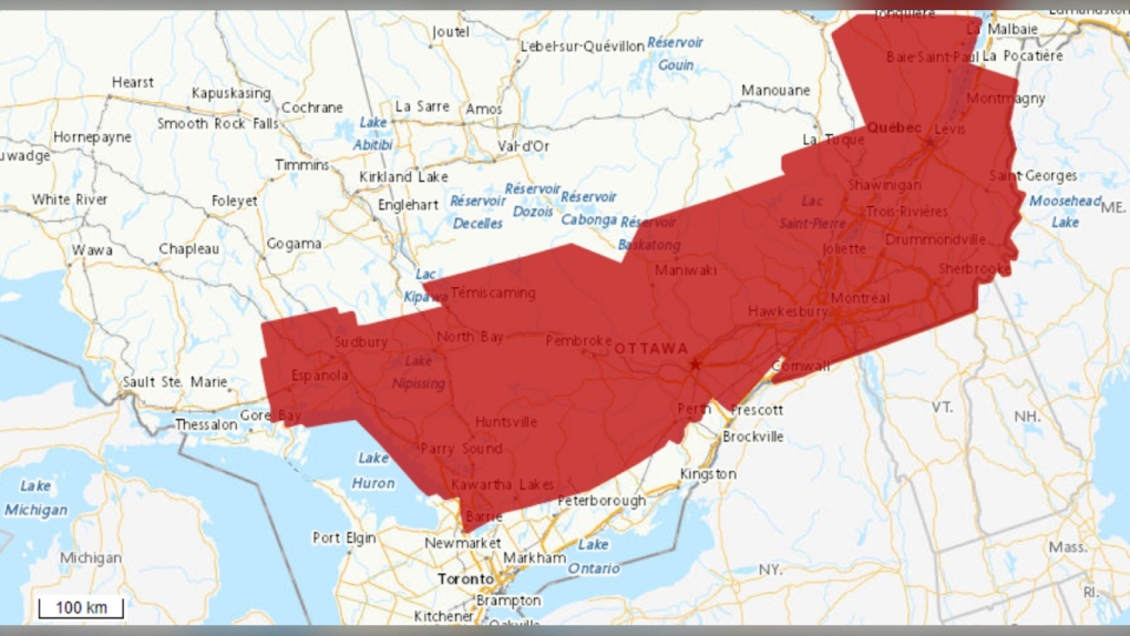 Weather alert map for northern Ontario (Red - warnings) as of 9:30 a.m. on June 23, 2024. (Environment and Climate Change Canada)
The warning includes communities in and around Greater Sudbury, North Bay and Parry Sound. The warnings in the vicinity of Sault Ste. Marie have now been lifted.
“Scattered showers continue this (Sunday) morning and are expected to become more widespread through the late morning and early afternoon,” Environment Canada said.
The rainfall is expected to be heavy at times, meteorologists predict, with an additional 10 to 25 mm in most areas.
“Heavy downpours can cause flash floods and water pooling on roads,” reads the warning.
“Localized flooding in low-lying areas is possible. Watch for possible washouts near rivers, creeks and culverts.”
For information concerning flooding, visit Ontario.ca/floods for the latest details.
“Scattered showers are expected to continue into this evening, but no significant amounts are expected,” said Environment Canada.
To report severe weather, send an email to ONstorm@ec.gc.ca or tweet reports using #ONStorm.


CTVNews.ca Top Stories

BREAKING
BREAKING Hurricane Helene death toll rises, dozens are still trapped in damaged homes
The Georgia governor says at least 11 people in his state have been killed and dozens are still trapped in homes damaged by Hurricane Helene.
Family of man killed by Calgary police issues statement
The family of Jon Wells, a man killed by Calgary police earlier this month, say they are seeking time to grieve their loss.
1 person hospitalized, 550 people symptomatic after illness outbreak at P.E.I. shellfish festival
More than 550 symptomatic people responded to an online questionnaire about a gastrointestinal illness at a Prince Edward Island shellfish festival last weekend.
Maggie Smith, scene-stealing actor famed for Harry Potter and 'Downton Abbey,' dies at 89
Maggie Smith, the masterful, scene-stealing actor who won an Oscar for 1969 film 'The Prime of Miss Jean Brodie' and gained new fans in the 21st century as the dowager Countess of Grantham in 'Downton Abbey' and Professor Minerva McGonagall in the Harry Potter films, died Friday. She was 89.
Israel says it struck Hezbollah's headquarters as huge explosions rocked Beirut
A series of intense Israeli airstrikes hit one of Beirut's heavily populated southern suburbs on Friday as blasts were heard throughout the Lebanese capital.
What's 'chroming'? Experts explain the dangerous social media trend among youths
Chroming, or getting high via inhaling hydrocarbons by misusing a variety of legal products, is trending among adolescents, and it sometimes ends in death.
Police make four more arrests in viral video that showed woman stealing Porsche from Mississauga driveway
Police have arrested four more people in connection with a viral video that showed a woman stealing a Porsche from a Mississauga driveway and then striking its owner as she attempted to flee the scene.
Iranian operatives charged in the U.S. with hacking Donald Trump's presidential campaign
The U.S. Justice Department unsealed criminal charges Friday against three Iranian operatives suspected of hacking Donald Trump's presidential campaign and disseminating stolen information to media organizations.
It was supposed to be a brief work trip to Uganda. Now he owes a hospital $30K
A man from Alberta has been at the Medipal International Hospital in Kampala, Uganda for over two months with a hefty medical bill. He says he can’t leave until it’s been paid for.
Shopping Trends
The Shopping Trends team is independent of the journalists at CTV News. We may earn a commission when you use our links to shop. Read about us.


Barrie
-

Police swarm home after man allegedly confronts snowmobile owner with crossbow
Several heavily armed officers descended on a home in the southeast area of Barrie Thursday afternoon after reports of a man armed with a crossbow.
-
'Violent extortion message' sent via email is a scam, OPP warns
Members of the Southern Georgian Bay OPP and the Canadian Anti-Fraud Centre (CAFC) are sounding the alarm on a rising number of online and phone scams targeting residents.
-
Court appearance for Beeton man accused of sexually assaulting a child
A Beeton, Ont., man accused in a historical sex crimes case involving a five-year-old girl made his first virtual court appearance on Thursday in Bradford.
Toronto
-

Police make four more arrests in viral video that showed woman stealing Porsche from Mississauga driveway
Police have arrested four more people in connection with a viral video that showed a woman stealing a Porsche from a Mississauga driveway and then striking its owner as she attempted to flee the scene.
-
Ontario education minister issues warning against 'inflammatory' content in schools ahead of Oct. 7 anniversary
Ontario Education Minister Jill Dunlop is advising school boards to leave politics out of the classroom in the lead-up to the one-year anniversary of the Oct. 7 terror attack which sparked the Israel-Hamas war.
-
3 charged with attempted murder after exchange of gunfire at King Township home
Three people have been charged with attempted murder after an exchange of gunfire at a home in King Township on Thursday morning, York Regional Police say.
Ottawa
-

Ottawa Hospital parking rates set to increase starting Tuesday
Parking rates at The Ottawa Hospital (TOH) will increase as of Tuesday for patients, visitors and staff.
-
OPP respond to 29 domestic dispute calls in one week, issue two warrants in eastern Ontario
Ontario Provincial Police say they responded to 29 calls related to domestic disputes last week in eastern Ontario.
-
Gatineau, Que. man, 35, killed in apparent assault, police arrest 2 suspects
Police in Gatineau, Que. say two suspects have been arrested following the third homicide of the year in the city. A 35-year-old man has been identified as the victim following an apparent assault.
Kitchener
-

Councillors, advocates question report on corn crop destruction in Wilmot Township
Advocates are demanding an apology after a staff report regarding the destruction of corn crops in Wilmot Township was found to be lacking in detail.
-
Elderly pedestrian dies after being struck by a vehicle: Guelph police
Guelph police say an elderly woman has died after she was struck by a vehicle Thursday afternoon on Eramosa Road.
-
Teen charged after noxious substance sprayed outside Guelph school
A high school student from Guelph has been charged after police were called to a south-end school on Thursday.
London
-

Third suspect arrested following July shooting incident in London
A third person has been arrested following a shooting in London in July. Police had previously said officers were looking for Dean Robert Dickieson, 31, who they say has now been arrested.
-
Muslim woman allegedly attacked in London, Ont.
The National Council of Canadian Muslims and Hikma Public Affairs Council have both released statements on social media regarding the reported incident.
-
LPS release images of possible arson suspect
The person was previously described as thin white man between 20 and 40 years old. He was wearing a black hoodie with a white logo on the front, and was also wearing a black and white baseball cap.
Windsor
-

Another fire at former Mission Thrift Store location
A second fire is being reported at the former Mission Thrift Store location on Giles Boulevard.
-
Four guns and $120,000 seized in Tecumseh: OPP
OPP have seized four guns and around $120,000 after a search warrant was executed in Tecumseh.
-
Driver flees collision with a bumper lodged in the side of his car
A 20-year-old from Windsor was arrested for dangerous driving following a collision in Amulree on Wednesday.
Montreal
-

2 possible tornadoes touch down in Quebec, Environment Canada says
Environment Canada said that two tornadoes reportedly touched down Thursday afternoon in Quebec's Mauricie region.
-
Quebec MNA accuses SAQ of being backed by 'racist, far-right pro-genocide groups'
Quebec solidaire (QS) accused Quebec's liquor control board of being supported by 'racist, far-right pro-genocide groups."
-
Protest over sudden closure of beloved Montreal music venue La Tulipe
Several people gathered near Mount-Royal and Papineau Avenue Thursday night to protest the closure of La Tulipe.
Winnipeg
-

Ontario woman arrested following alleged child abduction: Manitoba RCMP
An Ontario woman who allegedly abducted her three children from Ontario and crossed into Manitoba was arrested in Saskatchewan this week.
-
Who owns 'Every Child Matters'?
One non-profit organization is laying claim to the phrase 'Every Child Matters' in an attempt to control how it is used.
-
Winnipeg police charge Saskatchewan man with human trafficking
The Winnipeg Police Service (WPS) has arrested a Saskatchewan man on human trafficking charges.
Atlantic
-

1 person hospitalized, 550 people symptomatic after illness outbreak at P.E.I. shellfish festival
More than 550 symptomatic people responded to an online questionnaire about a gastrointestinal illness at a Prince Edward Island shellfish festival last weekend.
-
Youth who pleaded guilty in Halifax-area school stabbing to be sentenced Friday
A youth charged with stabbing two staff members at a Bedford, N.S., high school in March 2023 will be sentenced Friday afternoon.
-
Nova Scotia deficit expected to hit $654 million
Nova Scotia’s deficit is expected to reach $654 million for the 2024-2025 fiscal year – a $187-million increase from the government’s projections in March.
N.L.
-

Small English soccer team has huge year, thanks in part to Newfoundland and Labrador
A soccer game in England on Tuesday night drove a spike in online traffic across the Atlantic to a website launched by the Newfoundland and Labrador government.
-
Luck of the draw: N.L. ads to be featured in match against football giants Chelsea
Newfoundland and Labrador sponsored a minor football team in England, now they’re about to play one of the biggest clubs in European soccer.
-
Newfoundland and Labrador monitoring rise in whooping cough cases: medical officer
Newfoundland and Labrador's chief medical officer is monitoring the rise of whooping cough infections across the province as cases of the highly contagious disease continue to grow across Canada.
Calgary
-

Family of man killed by Calgary police issues statement
The family of Jon Wells, a man killed by Calgary police earlier this month, say they are seeking time to grieve their loss.
-
Suncor Energy pleads guilty to charges for 2019 injury on oil vessel off Newfoundland
Suncor Energy has been fined $90,000 after pleading guilty to two charges stemming from a worker injury in 2019 aboard its production vessel in an oilfield off the coast of Newfoundland.
-
Calgary construction supervisor fined $30K for workplace injury
A construction supervisor has been fined $30,000 in connection with a serious workplace injury in Calgary in 2021.
Edmonton
-

New numbers show Alberta lowest in Canada on per capita spending on inmates
New data shows Alberta spends the lowest amount of money per inmate in Canada – a number the province says is value for money but critics label short-sighted and worrisome.
-
Crash closes westbound Highway 16 west of Edson
A crash scene made westbound Highway 16 impassable west of Edson Friday morning.
-
Josh Classen's forecast: Sunshine and warm temperatures, but windy
The wind may put a damper on the last 20-degree day we'll see for a while in Edmonton.
Regina
-
 EXCLUSIVE
EXCLUSIVE New poll reveals some key issues for voters in upcoming Sask. election
The most important issues for Saskatchewan voters depends on which party they support, according to a new poll.
-
Sask. gov't run grocery stores, PST cuts promised in pre-campaign announcements
The Progressive Conservative Party of Saskatchewan says a former government-run liquor store would be turned into a government-operated grocery store if the party were to form government.
-
RCMP on scene of two vehicle collision east of Regina, delays expected
White Butte RCMP said officers were called to a two vehicle collision Friday morning along Highway 1 just east of Regina near the bypass.
Saskatoon
-
EXCLUSIVE
EXCLUSIVE New poll reveals some key issues for voters in upcoming Sask. election
The most important issues for Saskatchewan voters depends on which party they support, according to a new poll.
-
Winnipeg police charge Saskatchewan man with human trafficking
The Winnipeg Police Service (WPS) has arrested a Saskatchewan man on human trafficking charges.
-
Sask. teen charged in arson attack says 'voices told her to do things'
A lawyer defending a 14-year-old accused of setting a classmate on fire says 'voices told her to do things' prior to a fiery attack which severely injured a classmate and a teacher at Evan Hardy Collegiate earlier this month.
Vancouver
-

Doorbell camera captures tense bear showdown at B.C. family's front door
There were some tense moments for a B.C. family this week after their dog came face-to-face with a protective mama bear right outside their front door.
-
Jann Arden in Vancouver to oppose export of Canadian horses for slaughter
Singer and songwriter Jann Arden is in Vancouver on Friday to raise donations and awareness in an effort to stop the export of live horses for slaughter overseas.
-
Pornographic video aired during Kamloops city council meeting
The City of Kamloops is issuing a public apology for what it’s calling "inappropriate behavior" that happened during Tuesday's council meeting.
Vancouver Island
-

Breathtaking encounter with humpback whales captured by B.C. filmmakers
When a group of B.C. filmmakers set out on a small fishing boat near Powell River last week, they hoped to capture some video for a documentary on humpback whales. What happened next blew their minds.
-
B.C. company sanctioned by U.S. Treasury Department wants Health Canada licences back
A chemical firm based in Port Coquitlam, B.C., claims Health Canada wrongfully cancelled its licences to make natural health products after being sanctioned by the U.S. Treasury Department for alleged involvement in importing precursor chemicals that could be used in illicit drug production.
-
Canadian warship rearms in Australia, a 'significant' milestone for deployed frigates, DND says
A Royal Canadian Navy warship was rearmed with missiles and munitions in Australia this week, marking the first ever overseas rearmament for the service's Halifax-class frigates.


