36 forest fires burning in the northeast, 3 out of control
As of Sunday morning, there were 36 active wildfires in northeastern Ontario with two new fires confirmed on Saturday – one of which is already out – and one confirmed Sunday morning. Three fires are not under control, two are being held, nine are under control and 22 are being observed.
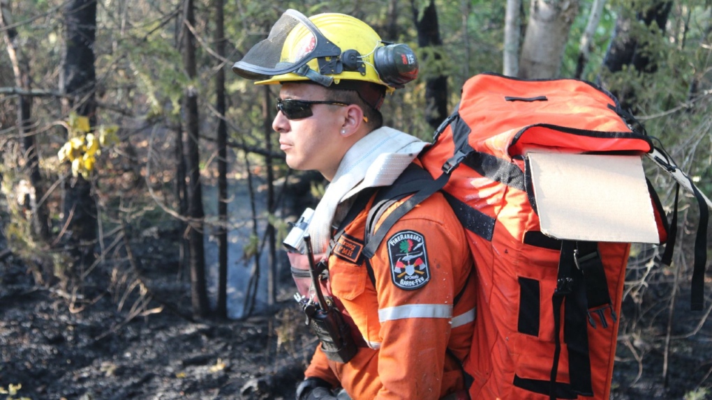 An Ontario fire ranger wearing a hose pack walks through a forested area in this undated photo.(Aviation, Forest Fire and Emergency Services/X)
Still burning out of control
The out-of-control fire is Kirkland Lake 5, located approximately five kilometres north of Stull Lake and five kilometres southeast of McKee Lake and approximately 80 kilometres west of Latchford, the forest fire was confirmed on Aug. 3.
“This fire is 889 hectares in size,” Ministry of Natural Resources & Forestry’s (MNRF) Aviation, Forest Fire and Emergency Services (AFFES) in their report at about 6:30 p.m. on Saturday.
“Fire ranger crews and helicopters with bucketing capabilities continue to work on this fire.”
Provincial officials said Kirkland Lake 5’s perimeter has been updated on the province’s interactive map.
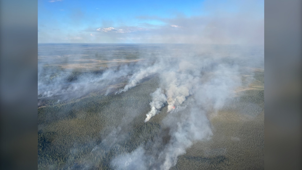
 Officials with the Ministry of Natural Resources and Forestry continue to work on putting out Kirkland Lake 5, a forest fire burning near Temiskaming Shores. (Northeast Region Aviation, Forest Fire and Emergency Services/Jean Quesnelle)
Wawa 13, located approximately 13 kilometres east of Negwazu Lake and 18 kilometres north of Highway 519, now measures 29.5 hectares. The forest fire was confirmed on August 21 and continues to receive fire aerial support.
Newly confirmed North Bay 16 is also not under control. The fire measures 0.2 hectares as the time of this publication and is located on the shores of Net Lake north of Temagami.
Other fires of note
After increase fire activity last week, Timmins 16, located south of Bigwater Lake, approximately 10 kilometres north of Timmins and 0.2 kilometres west of Highway 655, is now under control. When the now 3.1-hectare fire was confirmed on Wednesday, it received a joint response with the municipality’s local fire services along with MNRF crews actioning the fire in addition to aerial fire suppression support.
Following Timmins 16’s increased activity waterbombers assisted in suppressing the fire.
Wawa 14, located approximately 21.6 kilometres southeast of Marathon, was confirmed on Saturday. The 0.1 hectare fire is now under control after a fire crew battled it Saturday.
North Bay 15 was also confirmed on Saturday but is now out. The fire was located on the east side of Sucker Gut Lake within Obabika River Provincial Park, approximately 33.5 kilometres west of Latchford and had burned 0.2 hectares. AFFES had committed a fire ranger crew to North Bay 15 on Saturday.
Being observed
Chapleau 8, Hearst 10 and North Bay 11 along with 19 fires in the Cochrane district are being observed – with Cochrane 9 burning since June 2 and now measuring more than 6,000 hectares.
“Cochrane 9, is now being observed,” said MNRF officials on social media earlier this season.
“Initially very active, it has seen many bouts of significant rain. This Far North fire is now being monitored to allow the natural ecological benefits of fire on the landscape.”
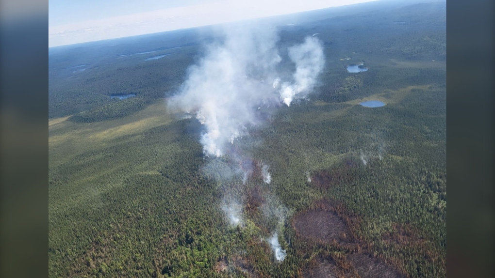
 Aerial view of Cochrane 9 in early June 2024. (Ministry of Natural Resources & Forestry/X | Photo Credit: Chad Porter/Cochrane Fire Management Headquarters)
Fire hazard levels
The fire hazard ranges from low to high across the northeast region, according to the ministry’s update Saturday evening.
“The fire hazard is low for areas along the Highway 11 corridor east of Hawk Junction to Dana-Jowsey Lakes and for the central portion of the Highway 144 corridor. There are spots of low fire hazard east of Iroquois Falls, between Latchford and Temiskaming Shores, and between Desbarats and Dayton,” reads the update.
“The fire hazard is high for areas around Blind River and Elliot Lake through to French River, Powassan, Parry Sound and McCrae Lake. The fire hazard is also high for Hearst going north to James Bay and the Quebec border.”
The rest of the region is seeing a moderate fire hazard rating.
Interactive fire map
The MNRF’s interactive map visually shows active fires, current fire danger across Ontario and any restricted fire zones in effect with real-time updates as information becomes available.
The map can be viewed here.
Reporting a wildland fire
To report a wildland fire located north of the French and Mattawa rivers, please dial 310-FIRE. To report a wildland fire located south of the French or Mattawa Rivers, please dial 911.
Shopping Trends
The Shopping Trends team is independent of the journalists at CTV News. We may earn a commission when you use our links to shop. Read about us.


CTVNews.ca Top Stories

5 rescued after avalanche triggered north of Whistler, B.C. RCMP say
Emergency crews and heli-skiing staff helped rescue five people who were caught up in a backcountry avalanche north of Whistler, B.C., on Monday morning.
Quebec fugitive killed in Mexican resort town, RCMP say
RCMP are confirming that a fugitive, Mathieu Belanger, wanted by Quebec provincial police has died in Mexico, in what local media are calling a murder.
Bill Clinton hospitalized with a fever but in good spirits, spokesperson says
Former President Bill Clinton was admitted Monday to Georgetown University Medical Center in Washington after developing a fever.
Trump again calls to buy Greenland after eyeing Canada and the Panama Canal
First it was Canada, then the Panama Canal. Now, Donald Trump again wants Greenland. The president-elect is renewing unsuccessful calls he made during his first term for the U.S. to buy Greenland from Denmark, adding to the list of allied countries with which he's picking fights even before taking office.
UN investigative team says Syria's new authorities 'very receptive' to probe of Assad war crimes
The U.N. organization assisting in investigating the most serious crimes in Syria said Monday the country’s new authorities were “very receptive” to its request for cooperation during a just-concluded visit to Damascus, and it is preparing to deploy.
Pioneering Métis human rights advocate Muriel Stanley Venne dies at 87
Muriel Stanley Venne, a trail-blazing Métis woman known for her Indigenous rights advocacy, has died at 87.
King Charles ends royal warrants for Ben & Jerry's owner Unilever and Cadbury chocolatiers
King Charles III has ended royal warrants for Cadbury and Unilever, which owns brands including Marmite and Ben & Jerry’s, in a blow to the household names.
Man faces murder charges in death of woman who was lit on fire in New York City subway
A man is facing murder charges in New York City for allegedly setting a woman on fire inside a subway train and then watching her die after she was engulfed in flames, police said Monday.
Canada regulator sues Rogers for alleged misleading claims about data offering
Canada's antitrust regulator said on Monday it was suing Rogers Communications Inc, for allegedly misleading consumers about offering unlimited data under some phone plans.
Barrie
-

Several collisions reported along Highway 11 as driving conditions deteriorate
Highway 11 was closed briefly in Oro-Medonte on Monday afternoon as driving conditions deteriorated, causing multiple collisions.
-
Theft, vehicle break-ins, and fraud top police reports during holidays
Police in Barrie are urging residents to be vigilant this holiday season, as theft, theft from vehicles, and fraud consistently rank as the most reported crimes during this time of year.
-
Student charged, firearms seized after threats against school: police
Police say officers found several firearms during a search at a teen’s home after he allegedly made violent threats against a secondary school.
Toronto
-
 DEVELOPING
DEVELOPING Parts of Ontario under snowfall warning Monday as holiday travellers hit the road
Holiday travellers and commuters could be in for a messy drive on Monday morning as a significant round of snowfall moves into the region. Here are live updates on the situation in Toronto.
-
Everything you need to know about what’s open on Christmas in the GTA
Here's what you need to know about what's open and closed in the GTA over the Christmas holidays.
-
Pedestrian taken to hospital after being struck by vehicle in Forest Hill
A male pedestrian was rushed to the hospital after being struck by the driver of a vehicle in Toronto's Forest Hill area Monday night.
Ottawa
-

Traffic dispute threatens to dampen holiday spirit on Taffy Lane
A visit to Ottawa's Taffy Lane in Orléans is a staple this time of year, but a dispute amongst neighbours over traffic congestion is threatening to dim the magic of the holidays for one neighbour.
-
Ottawa mayor speaks on transit funding, federal turmoil in year-end interview
Ottawa Mayor Mark Sutcliffe spoke with CTV News on a variety of issues, including transit, the city budget and political turmoil on Parliament Hill in a year-end interview.
-
SNOWFALL WARNING
SNOWFALL WARNING Pre-Christmas storm forecasted in Ottawa with up to 20 cm of snow tonight
Environment Canada has issued a snowfall warning for Ottawa and parts of eastern Ontario with a snowstorm in the forecast Monday afternoon and into the evening.
Kitchener
-

Winter weather travel advisory before Christmas
Anyone planning to travel is being urged to be prepared as 5 to 15 cm of snow could hit a large portion of southern Ontario on Monday.
-
Beloved bookstore in Uptown Waterloo forced to close for months following fire
A beloved bookstore in Uptown Waterloo is bearing the brunt of some holiday misfortune.
-
Must-see moments of 2024: A superstar surprise, roundabout resident and CKCO studios come down
From a WWE surprise for a Guelph superfan, to the recovery of a lost aviation artifact, to a reporter getting the story right from the goose's mouth, here are some of our can’t-miss moments from 2024.
London
-

Blast of Ontario snow brings weather warnings, signs of white Christmas
A white Christmas is forecasted for parts of Ontario as winter weather and snowfall sweeps across the province Monday.
-
91-year-old harness driver victorious at The Raceway in London, Ont.
A 91-year-old harness driver raced his way to victory on Friday night with his horse, Willy Strike.
-
SIU concludes LPS was justified in striking a man in August arrest
Following an incident in August, the province’s police watchdog has concluded that a London Police Service officer did not commit a criminal offense.
Windsor
-

Restaurant staff aid in rescue of two men that fell into the frigid waters of the Detroit River
Windsor police say that shortly before 9:00 p.m. on Dec. 20, officers were called after a man fell into the water while standing too close to the marina wall. A second man jumped in to help him.
-
Early morning blaze that displaced two people deemed suspicious
Windsor fire was on scene of an early morning blaze in the 1500 block of Pelissier Street on Monday.
-
Child luring investigation sees Windsor resident charged
According to Essex OPP, 45-year-old Shaun Ouellette is facing charges of luring a person under 16 years of age by means of telecommunication.
Montreal
-

Quebec fugitive killed in Mexican resort town, RCMP say
RCMP are confirming that a fugitive, Mathieu Belanger, wanted by Quebec provincial police has died in Mexico, in what local media are calling a murder.
-
Guzzo Group says it wants to protect its 500 employees
Although the Guzzo Group is currently in turmoil, it is reassuring its employees and customers about the year ahead.
-
Snow on the way as Montreal is under weather advisory
A weather advisory has been issued for the Greater Montreal area, with 10 to 15 cm of snow expected to hit the ground.
Winnipeg
-

An alleged sniper, pair of animal claims featured on MPI’s top five fraud list for 2024
From hitting animals that weren’t there to a sniper that didn’t exist, Manitoba Public Insurance has released its top five frauds of 2024.
-
Manitoba government to make permanent cut to gas tax
Manitobans can expect to see a permanent change at the gas pump as early as next week
-
Winnipeg police arrest corrections officer following sexual assault of a youth
A corrections officer at a “youth custody facility” has been arrested following a number of sexual assaults against a youth.
Atlantic
-

Court of appeal certifies class action lawsuit against health authority, former nurse
A New Brunswick mother who is the lead plaintiff in a court case has received an early Christmas gift after the province’s top court certified her class-action lawsuit.
-
No need to dream, White Christmas all but assured in the Maritimes
An early nor'easter followed by a low-pressure system moving into the region all but ensure a Maritime White Christmas
-
CTV’s Katie Kelly solves decades old mystery involving “anchor” tattoo
It’s been almost two decades since a 21-year-old man from New Glasgow, N.S., got a tattoo of CTV’s Bruce Frisko, but it’s a piece of Maritime history that hasn’t been forgotten.
N.L.
-

A massive, menacing Steller's sea eagle is dazzling birders in a Newfoundland park
A national park in Newfoundland has made the unusual move of opening in the winter so people can catch a glimpse of its rare and menacing new guest.
-
Newfoundland woman washed sick patients' hair every Saturday for more than 20 years
A retired nurse and teacher in Newfoundland was honoured this week for her volunteer work, which included more than two decades washing the hair of bedridden hospital patients.
-
Newfoundland man facing more charges related to youth sex crimes
A 64-year-old Newfoundland man charged with dozens of sex crimes involving young people is facing several new charges.
Calgary
-

Low Canadian dollar a 'double-edged sword' as more Americans travel north: economist
A Calgary economist says the low Canadian dollar is a mixed blessing, with data showing that more Americans are travelling north to make the most of their spending.
-
Taxpayers Federation unveils its annual spending 'Naughty and Nice List'
A media president and the Prime Minister have topped the Canadian Taxpayers Federation’s annual 'Taxpayer Naughty List' for 2024.
-
Roughriders acquire quarterback Maier's rights from Stampeders for '25 draft pick
The Saskatchewan Roughriders acquired the rights to veteran quarterback Jake Maier from the Calgary Stampeders on Monday for a 2025 eighth-round draft pick.
Edmonton
-

'Serious safety issues': Edmonton building where security guard was killed evacuated
An apartment building where a security guard was killed earlier this month has been evacuated.
-
Oilers enter holiday break on an NHL tear
The Edmonton Oilers' victory on Sunday over the Ottawa Senators was the 11th in their last 13 games.
-
City of Edmonton to lift Phase 1 parking ban Monday evening
The City of Edmonton will lift the Phase 1 parking ban on Monday at 5 p.m.
Regina
-

'A nice way to connect': Christmas card exchange between Sask. friends spans 60 years
What started out as a little holiday fun between two Regina friends has turned into a tradition that now spans six decades.
-
Dog lost in Saskatchewan during cross-country trip reunited with family
A family moving from Ontario to Alberta in November had a scare when their family dog got loose during a stop in Dafoe, Sask. and ran away.
-
Estevan police officer arrested following SIRT investigation
An officer of the Estevan Police Service (EPS) is facing several charges following an investigation by the province’s police oversight agency.
Saskatoon
-

Personalized license plates on the rise in Saskatchewan
You may have noticed a few more vanity plates on Saskatchewan roads in recent years, and every one of them comes with a personal story.
-
'There are lines': In year-end interview, NDP leader says Moe went too far in election campaign
Saskatchewan’s two main political leaders had agreed before October's provincial election not to target the families of candidates during the campaign, says Opposition NDP Leader Carla Beck.
-
Sask. RCMP on the scene of rollover on Highway 40
The Saskatchewan RCMP said Highway 40 was closed Monday afternoon following a rollover just west of Hafford, a village just under 100 kilometres northwest of Saskatoon.
Vancouver
-
5 rescued after avalanche triggered north of Whistler, B.C. RCMP say
Emergency crews and heli-skiing staff helped rescue five people who were caught up in a backcountry avalanche north of Whistler, B.C., on Monday morning.
-
B.C. woman sentenced for impaired driving crash that killed retired Mountie
A Vancouver Island woman who was high on drugs when she crashed a car into a pickup truck, killing a retired Mountie and injuring his two passengers, "did not realize what was happening and took no steps to avoid the accident" a B.C. Supreme Court judge found.
-
'They have their families to feed': YVR janitors set to escalate job action
Approximately 230 janitors at Vancouver International Airport are set to escalate job action Tuesday at "undisclosed areas of the airport."
Vancouver Island
-

B.C. woman sentenced for impaired driving crash that killed retired Mountie
A Vancouver Island woman who was high on drugs when she crashed a car into a pickup truck, killing a retired Mountie and injuring his two passengers, "did not realize what was happening and took no steps to avoid the accident" a B.C. Supreme Court judge found.
-
5 rescued after avalanche triggered north of Whistler, B.C. RCMP say
Emergency crews and heli-skiing staff helped rescue five people who were caught up in a backcountry avalanche north of Whistler, B.C., on Monday morning.
-
Cleanup underway after rockslide derails train in B.C.
No injuries were reported after a rockslide derailed a freight train, sending railcars into British Columbia's Fraser River, on Sunday night.


