Weather alerts issued in the northeast for expected first accumulating snowfall, rain warning
Environment Canada issued weather alerts Wednesday in anticipation of severe thunderstorms heavy rain of up to 60 mm and the first accumulating snowfall of the season in the northeast with up to 10 cm expected.
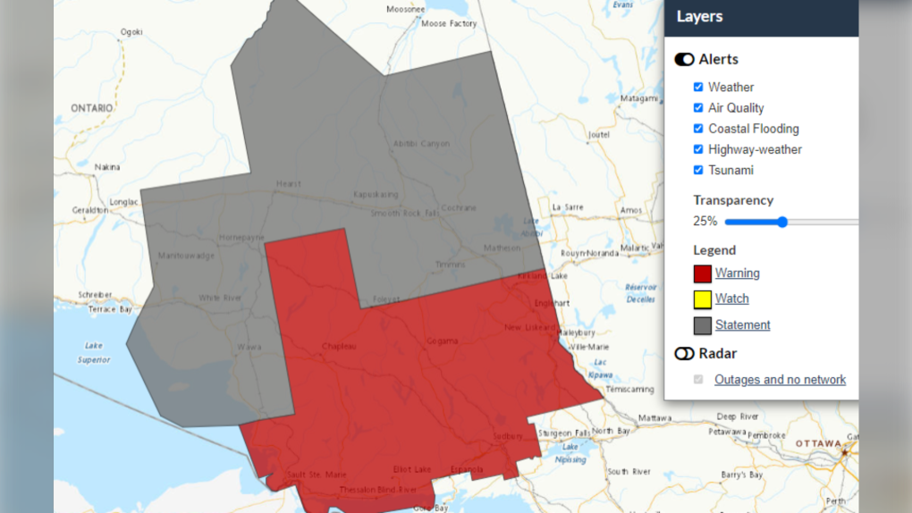
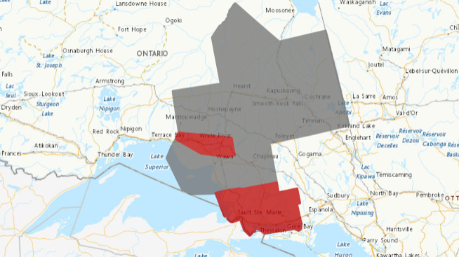
 Halloween weather alerts in northeastern Ontario. Oct. 31, 2024 (Environment Canada)
The above-seasonal temperatures in the region Wednesday are not expected to last as rain turns to snow Thursday with a steep drop in temperature from a high of 18 C to a low of -4 C forecasted in Timmins.
The rainfall warnings issued Wednesday have been extended east Markstay-Warren along Highway 17 and to the Quebec border from Temiscaming to Kirkland Lake.
Snow up to 10 cm
The northern portions of the northeast, particularly Wawa to Timmins, will be affected most by the messy weather.
"Snow may be mixed with ice pellets or freezing rain at times Thursday afternoon and evening," Environment Canada said Wednesday morning in a special weather statement.
"Snow is expected to taper to flurries Friday morning. Total snowfall amounts are fairly uncertain, however, snowfall amounts near 10 cm are possible."
Travellers should prepare for quickly changing and deteriorating road conditions.
Communities along Highway 11 included in the weather alert are Matheson to almost Longlac.
Rainfall warning
A rainfall warning has been issued for the Sault Ste. Marie area that stretches to Massey.
Nearly 60 mm of rain is expected by Friday morning, with slightly higher amounts possible in embedded thunderstorms.
"Rain will begin this afternoon and continue through Friday morning as a low-pressure system begins to affect the region," the weather alert said Wednesday morning.
"Total rainfall amounts near 60 mm are expected … Rain will taper and transition to scattered showers or flurries Thursday night into Friday morning."
Flash floods and water pooling on roads can be caused by heavy downpours.
"If visibility is reduced while driving, turn on your lights and maintain a safe following distance," Environment Canada said.
Weather alert map Wednesday:
 Environment Canada weather alert map for northern Ontario. Oct. 30, 2024. (Red - Severe thunderstorm warning or rainfall warning, Grey - special weather statement)
Severe thunderstorm warning
Also in the Wawa area, Environment Canada issued a severe thunderstorm warning Wednesday morning.
"At 9:44 a.m. EDT, Environment Canada meteorologists are tracking a severe thunderstorm capable of producing strong wind gusts and up to toonie size hail," the weather warning said.
"This severe thunderstorm is located near Pukaskwa National Park, moving east at 95 km/h."
As of 10:19 a.m., the severe thunderstorm warning ended for Wawa, Geoff Coulson, a warning preparedness meteorologist told CTVNewsNorthernOntario.ca in an email.
"(The warning) will likely end shortly for the White River area as the storm cells are moving fairly quickly," Coulson said.
"However, it may be expanded northeastward as the cells involved continue tracking in that direction."
When threatening weather approaches, Emergency Management Ontario said to take cover immediately.
"Lightning kills and injures Canadians every year," the weather alert said.
"Remember, when thunder roars, go indoors!"
In addition to causing injury, large hail can damage property.
"Strong wind gusts can toss loose objects, damage weak buildings, break branches off trees and overturn large vehicles," Environment Canada said.
CTVNews.ca Top Stories

Donald Trump says he urged Wayne Gretzky to run for prime minister in Christmas visit
U.S. president-elect Donald Trump says he told Canadian hockey legend Wayne Gretzky he should run for prime minister during a Christmas visit but adds that the athlete declined interest in politics.
Ho! Ho! HOLY that's cold! Montreal boogie boarder in Santa suit hits St. Lawrence waters
Montreal body surfer Carlos Hebert-Plante boogie boards all year round, and donned a Santa Claus suit to hit the water on Christmas Day in -14 degree Celsius weather.
Historical mysteries solved by science in 2024
This year, scientists were able to pull back the curtain on mysteries surrounding figures across history, both known and unknown, to reveal more about their unique stories.
Montreal man dead after boat explodes in Fort Lauderdale
A Montreal man is dead and several others are injured after a boat exploded in Fort Lauderdale, Florida.
Mother-daughter duo pursuing university dreams at the same time
For one University of Windsor student, what is typically a chance to gain independence from her parents has become a chance to spend more time with her biggest cheerleader — her mom.
Azerbaijani airliner crashes in Kazakhstan, killing 38 with 29 survivors, officials say
An Azerbaijani airliner with 67 people onboard crashed Wednesday near the Kazakhstani city of Aktau, killing 38 people and leaving 29 survivors, a Kazakh official said.
King Charles III focuses Christmas message on healthcare workers in year marked by royal illnesses
King Charles III used his annual Christmas message Wednesday to hail the selflessness of those who have cared for him and the Princess of Wales this year, after both were diagnosed with cancer.
Alberta premier hopes for health reform payoff in 2025, regrets deferring tax cut
"It may have been better for Albertans if we'd implemented and then found a way to be able to pay for it."
NFL's Netflix debut on Christmas Day kicked off without a glitch
Mariah Carey opened Wednesday’s doubleheader with a taped performance of “All I Want for Christmas is You” before Patrick Mahomes, Travis Kelce and the two-time defending Super Bowl champion Kansas City Chiefs faced off against Russell Wilson, T.J. Watt and the Pittsburgh Steelers.


