Weather alerts due to snow squalls continue for third day in the northeast
The lake effect snow is continuing to create weather alerts in northeastern Ontario for the third day in a row and some have been extended to Thursday.
Snow squall warnings and winter weather travel advisories are in effect Wednesday for communities near the Great Lakes and Lake Nipissing.
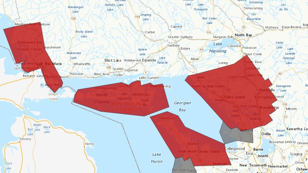 Weather alert map (red-snow squall warning and grey - winter weather travel advisory) as of 4:30 p.m. Jan. 17/24 (Environment Canada)
Heavy and blowing snow will create more hazardous travel conditions.
"Prepare for quickly changing and deteriorating travel conditions. If visibility is reduced while driving, slow down, watch for tail lights ahead and be prepared to stop," in a weather alert.
SUPERIOR EAST
North of Sault Ste. Marie, snow squalls started back up early Wednesday morning and will continue through Thursday morning, Environment Canada said.
"Snow squalls are expected to move into the area early this morning and will be located mainly between Batchawana Bay and Montreal River Harbour. Snow squalls will drift south into Searchmont later this evening," the snow squall warning said Wednesday.
"Local snowfall accumulations of 20 to 40 cm."
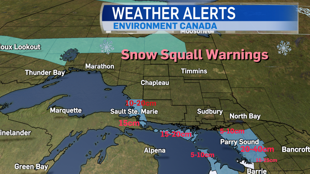 Weather alerts (Blue - snow squall warnings) for northeastern Ontario as of 4 p.m. Jan. 17/24 (Iselle Slome/CTV Northern Ontario)
Quickly deteriorating road conditions could prompt road closures.
"Consider postponing non-essential travel until conditions improve," Environment Canada said.
Shortly after 10 a.m. Wednesday, Environment Canada announced a snow squall watch was in effect for Sault Ste. Marie and St. Joseph Island.
Snow squalls are expected to begin late Wednesday afternoon and continue into Thursday morning with local snowfall totals of near 15 cm.
"Snow squalls are expected to move south into the area late this afternoon and will continue into Thursday morning," the weather alert said.
MANITOULIN ISLAND
Another snow squall warning is in effect for the island with 20 to 30 cm of more snow expected by Thursday morning.
ESPANOLA-KILLARNEY
Snow squall warning in effect and Environment Canada is forecasting 10 to 15 cm of more snow by late Wednesday afternoon.
"Snow squalls will continue to affect portions of the region this morning and will shift south out of the area late this afternoon," the weather alert said Wednesday.
GEORGIAN BAY
Communities east of Georgian Bay are also under weather warnings for a third day due to intense snow squalls.
The snow squalls are expected to shift south and out of the region Wednesday evening.
In the Bayfield Inlet and Dunchurch areas, 10 to 15 cm of snow is expected with peak snowfall rates of two to four cm/h possible.
Further south in the Parry Sound area and east to Huntsville, total snowfall of 20 to 40 cm is expected by early Thursday morning with peak snowfall rates of more than five cm/h possible, Environment Canada said.
The system will not move out of the Parry Sound/Rosseau/Killbear Park area until Thursday morning as it continues to move south.
Even higher amounts of snow are expected in the Port Carling and Port Severn areas and east to Bracebridge and Gravenhurst with 25 to 50 cm being forecasted by Thursday morning, where a winter weather travel advisory is in effect.
Snow squalls in these communities are expected to start back up around noon following flurries Wednesday morning.
- Download the CTV News app now
- Get local breaking news alerts
- Daily newsletter with the top local stories emailed to your inbox
In the Midland/Coldwater/Orr Lake areas, 15 to 20 cm of snow is expected through Thursday with snow squalls beginning later Wednesday afternoon as well.
FRENCH RIVER – WEST NIPISSING
Snow squall warnings are in effect for the West Nipissing and French River areas which are expected to get 10 to 15 cm of snow Wednesday.
"Snow squalls will continue to affect portions of the region this morning and will shift south out of the area late this afternoon," the weather alert said.
LAKE NIPISSING
Winter weather travel advisories are in effect for North Bay, Powassan and Mattawa on Wednesday as well due to lake-effect snow.
The snow continues throughout the morning and is expected to taper off late Wednesday afternoon as the weather system moves south.
Five to 10 cm of more snow is expected for Jan. 17.
Heavy and blowing snow will affect visibility in this area.
NORTH CHANNEL
Winter weather travel advisories have ended Wednesday afternoon along the north shore of Lake Huron for the communities of Blind River and Thessalon on Highway 17 east of Sault Ste. Marie.
"Additional local snowfall accumulation of 5 cm possible," the weather alert said Wednesday morning.
"Lake effect snow will taper off to flurries later this morning."
Shopping Trends
The Shopping Trends team is independent of the journalists at CTV News. We may earn a commission when you use our links to shop. Read about us.


CTVNews.ca Top Stories

'We'll never be the 51st state,' Premier Ford says following Trump’s latest jab
Ontario Premier Doug Ford says Canada will 'never be the 51st state,' rebuking U.S. President-elect Donald Trump’s latest social media post.
B.C. man drops camera into ocean, accidentally captures 'breathtaking' whale video
Before it turned into an extraordinary day, Peter Mieras says it began being quite ordinary.
'Why would I box myself in?': Singh on why he won't commit to helping bring Trudeau's gov't down, yet
NDP Leader Jagmeet Singh says U.S. president-elect Donald Trump's looming tariff threat is part of the reason why he's not committing to voting non-confidence in Prime Minister Justin Trudeau's government.
Elon Musk comes out swinging against government spending package in early test of his political might
Elon Musk derided a Republican-backed government spending bill that if not passed by Friday night would lead to a government shut down.
Providing MAID to man on day pass from B.C. psychiatric ward was 'unlawful,' family alleges
A 52-year-old man who was provided with a medically assisted death while out on a day pass from a B.C. psychiatric hospital should never have been approved for the life-ending procedure, his family alleges in a recently filed wrongful death lawsuit.
Donald Trump says Canada becoming 51st U.S. state is 'a great idea.' Jean Charest calls the comment a 'wake-up call'
U.S. President-elect Donald Trump is taking aim at Canada once more, saying it would be 'a great idea' to make it America's ‘51st state.'
Fashion influencer Matilda Djerf apologizes following report she created a toxic workplace
A social media influencer has issued an apology after reports that she created a 'work environment filled with fear and psychological pressure' at her company.
Police suspect Utah father killed his wife and 3 kids, wounded son, then killed himself
Five people were found dead in a Utah home after a man apparently shot his wife and four children before killing himself, police said Wednesday. A 17-year-old boy survived but has a severe brain injury.
What's the best treatment for ADHD? Large new study offers clues
Stimulant medications and certain therapies are more effective in treating ADHD symptoms than placebos, a new study on more than 14,000 adults has found.
Barrie
-

County warden sounds off on ongoing boundary dispute between municipalities
As tensions heat up between Barrie and its neighbouring municipalities over a possible change in boundaries, the warden is working towards getting everyone on the same page.
-
Fatal multi-vehicle crash on Highway 93 under investigation
Provincial police are investigating a multi-vehicle collision that claimed the life of one person in Springwater Township Wednesday morning.
-
Ont. father says police failed his family after 911 calls went unanswered
An Orangeville man is calling for accountability from Ontario Provincial Police (OPP) after he says thieves armed with a gun broke into his home and left his family traumatized.
Toronto
-
'We'll never be the 51st state,' Premier Ford says following Trump’s latest jab
Ontario Premier Doug Ford says Canada will 'never be the 51st state,' rebuking U.S. President-elect Donald Trump’s latest social media post.
-
Porter plane lands safely at Toronto Pearson airport after mayday call
A Porter Airlines flight from Ottawa landed safely at Toronto Pearson airport Wednesday evening after making a mayday call.
-
'I still haven't slept:' Oshawa mom finds bullet hole in daughter’s dresser after 14 shots fired at housing complex
An Oshawa mom discovered bullet holes in her daughter’s dresser and in the ceiling of her living room early Wednesday morning after police say more than a dozen shots were “indiscriminately” fired at a housing complex overnight.
Ottawa
-

New visitor centre opens in downtown Ottawa
A new visitor centre has opened in downtown Ottawa to assist the millions of tourists who flock to Canada's capital every year.
-
Inside the Shepherds of Good Hope's supportive housing on Merivale Road
CTV News Ottawa was invited to tour the facility at 1095 Merivale Rd. and speak to staff and residents following issues raised by those living nearby.
-
Here were the top baby names in Ottawa last year
Ontario unveiled the top baby names for 2023, and Olivia and Adam occupy the top spots in Ottawa.
Kitchener
-

One person arrested for jewelry store robbery at Conestoga Mall in Waterloo
Police have made an arrest in a jewelry store robbery at Conestoga Mall in Waterloo, Ont.
-
Victim in Cambridge apartment fire dies, despite the efforts of Good Samaritan
A woman who was injured in a fire at a Cambridge apartment building on Tuesday has died from her injuries.
-
Multiple shots fired into Cambridge home
Police said multiple residences reported damages “consistent with shots fired.”
London
-

Child struck by vehicle south of London has died
According to an online fundraiser organized by a family friend, the boy who was hit by a driver south of London earlier this week has died.
-
Dream Lottery grand prize winners announced
Dream Lottery announced their top winners Wednesday at the Royal Oak Dream Home in Thorndale.
-
'It was quite spectacular': LHSC brass marvel at staff professionalism during weekend shooting, improved security on the way
The provincially appointed supervisor at London Health Sciences Centre said improved security measures will be installed in the coming months at both the Victoria and University hospital sites.
Windsor
-

'High visibility' initiative launching at 920 Ouellette in Windsor
While frequent calls are received, police say about 75 per cent of them are non-criminal — including well-being checks, ambulance requests and non-violent persons in crisis.
-
Semi-automatic rifle seized at Ambassador Bridge
Canada Border Services Agency officers seized a semi-automatic rifle at the Ambassador Bridge.
-
Leamington warns of scammers impersonating municipal staff to access homes
The Municipality of Leamington is warning residents about a scam involving individuals falsely claiming to represent its water services department in an attempt to access people's homes.
Montreal
-

Canadiens trade Justin Barron to Predators for Alexandre Carrier
The Montreal Canadiens have traded defenceman Justin Barron to the Nashville Predators in exchange for blueliner Alexandre Carrier.
-
Sentencing Friday for Quebecer convicted of killing spouse, two children
A Quebecer convicted this week in a triple domestic murder that left a woman and her two young children dead in a Montreal suburb will be sentenced at the end of this week, a Superior Court justice decided Wednesday.
-
Patrick Liard appointed interim CEO of Urgences-sante
Urgences-santé has confirmed that Patrick Liard will replace François Charpentier as the head of the public paramedic organization.
Winnipeg
-

'Missed opportunities' identified in critical incident review of Earl Moberg case
The Winnipeg Regional Health Authority has apologized to Earl Moberg’s family after finding "missed opportunities" in the care of the 81-year-old man with advanced dementia who went missing a year ago.
-
'It gets us going': Federal government chips in $150 million for sewage plant
More money is flowing for Winnipeg's most expensive project, but it might not be enough to save ratepayers from sticker shock.
-
Threat against Thompson schools results in evacuation, classes cancelled
Classes will resume Thursday after multiple Thompson schools were threatened and the local high school evacuated.
Atlantic
-

Mix of snow, rain Wednesday night and Thursday; nor'easter Friday night into Saturday
A strong coastal storm threatens to bring heavy snowfall to parts of the Maritimes this weekend.
-
'A gift this size is extraordinary': Family donates $1M to N.S. hospital
A hospital foundation in Dartmouth, N.S., received a significant donation on Wednesday to help advance innovative and exceptional care.
-
Three people face charges in murder of Saint John man
Three people are facing charges in connection with the murder of 52-year-old Allan Lee, whose remains were found in Saint John, N.B., in the summer.
N.L.
-

Newfoundland man facing more charges related to youth sex crimes
A 64-year-old Newfoundland man charged with dozens of sex crimes involving young people is facing several new charges.
-
After fanfare of Churchill Falls deal, Newfoundland urged to learn its dam lessons
Energy observers in Newfoundland and Labrador are urging the provincial government to take a sober second look at a massive tentative deal announced last week with Quebec that promises to deliver hundreds of billions of dollars in revenue to the Atlantic province.
-
Backhoe used to tear the front off Newfoundland bank, four facing charges: RCMP
Four people in eastern Newfoundland are facing charges after a stolen backhoe was used to tear the front off the RBC bank in Holyrood.
Calgary
-

'This shouldn't happen': Family seeks changes after airline accessibility incident
A Calgary woman wants the airline WestJet to apologize to her daughter and to improve staff training on accessibility after an incident during their latest trip.
-
Province releases Green Line report amid growing pressure over cost estimate, design choices
After initially insisting its independent report on the new Green Line route needed to remain confidential, the province has made it public – with a lot of information missing.
-
Death of Calgary woman found badly injured on pathway ruled a homicide
Calgary police say the death of a woman found unconscious on a northeast pathway has been ruled a homicide.
Edmonton
-

Snow covers Edmonton, Phase 1 parking ban taking effect Thursday
It was all hands on deck Tuesday night and Wednesday morning to start clearing roads as snow descended on the Edmonton area.
-
Edmonton pediatrician sentenced to 18 months on child pornography charges
An Edmonton pediatrician who was found guilty on child pornography charges last year will spend 18 months in jail.
-
Donald Trump says Canada becoming 51st U.S. state is 'a great idea.' Jean Charest calls the comment a 'wake-up call'
U.S. President-elect Donald Trump is taking aim at Canada once more, saying it would be 'a great idea' to make it America's ‘51st state.'
Regina
-

'Create good Christmas memories for these kids': Regina schools experience Winter Wonderland
For the second year in a row, the Conexus Arts Centre was decorated as a Winter Wonderland and host to the Annual Community School Day.
-
Sask. Teachers' Federation and province await decision from binding arbitration hearing
The Saskatchewan Teachers’ Federation (STF) and the province are now awaiting a decision from the Arbitration Board following a binding arbitration hearing.
-
Highway conditions deteriorate across southern Sask. with snowfall warning in effect
Much of southern Saskatchewan remains under a snowfall warning on Wednesday afternoon, with 10 to 20 centimetres of snow expected to fall in some areas over the next 24 hours.
Saskatoon
-

'Should move forward': Still no plea from Saskatchewan student who allegedly set teen on fire
More than three months have passed since a Saskatoon girl was set on fire, yet her classmate charged in connection with the incident has still not made a plea.
-
'Don't want to lose any more people': Saskatoon rally calls for solutions for growing homeless population
David Fineday doesn't want any more of his friends to die on Saskatoon streets this winter.
-
Sask. Teachers' Federation and province await decision from binding arbitration hearing
The Saskatchewan Teachers’ Federation (STF) and the province are now awaiting a decision from the Arbitration Board following a binding arbitration hearing.
Vancouver
-

'I am suffering': B.C. hit-and-run victim pleads for driver to come forward
A hospitalized Burnaby, B.C., woman is asking the hit-and-run driver who put her there to come forward.
-
B.C. is the province least likely to want to join the United States, new poll suggests
British Columbians have little appetite to sever ties with Canada and join the United States, according to new polling.
-
B.C. mayor skeptical of feds' plan to bolster border security
On Tuesday, the Canadian government announced a $1.3-billion plan to bolster border security over the next six years.
Vancouver Island
-

Providing MAID to man on day pass from B.C. psychiatric ward was 'unlawful,' family alleges
A 52-year-old man who was provided with a medically assisted death while out on a day pass from a B.C. psychiatric hospital should never have been approved for the life-ending procedure, his family alleges in a recently filed wrongful death lawsuit.
-
B.C. is the province least likely to want to join the United States, new poll suggests
British Columbians have little appetite to sever ties with Canada and join the United States, according to new polling.
-
B.C. housing minister singles out 2 municipalities for lack of new home construction
In September 2023, the province gave 10 municipalities new home construction targets to meet in the first year under B.C.'s Housing Supply Act. The housing minster says two – West Vancouver and Oak Bay – didn’t come close.


