Weather alert upgraded to warning as winter storm approaches the northeast
The first major snowstorm of the year is still tracking to begin in the northeast Tuesday afternoon and is expected to bring up to 30 centimetres of snow over the next 24 hours.
Hazardous winter conditions caused by wind gusts up to 60 km/h creating poor visibility with blowing snow has prompted Environment Canada to upgrade the weather alert to a winter storm warning Tuesday morning.
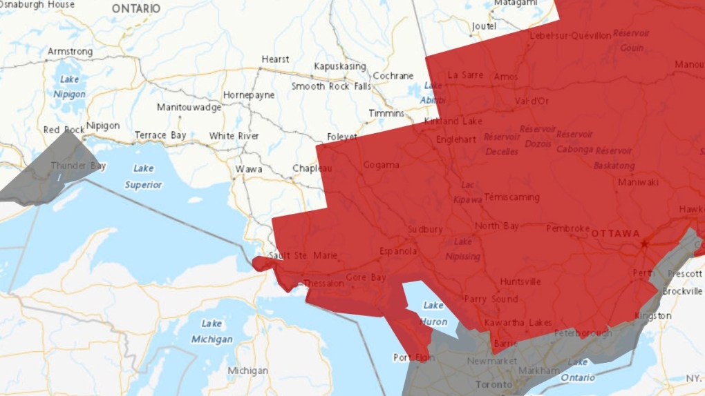 Environment Canada weather alert map Jan. 9. 24 (Red - winter storm warning, grey - special weather statement)
The winter storm warning is in effect for communities from Sault Ste. Marie east to the Quebec border – including Manitoulin Island -- and from Barrie north to Foleyet and Kirkland Lake.
Total snowfall amounts will range between 15 and 30 cm.
The worst part of the storm is expected Tuesday night into Wednesday morning.
"Surfaces such as highways, roads, walkways and parking lots may become difficult to navigate due to accumulating snow. Visibility will be suddenly reduced to near zero at times in heavy snow and blowing snow," Environment Canada said.
"If visibility is reduced while driving, slow down, watch for tail lights ahead and be prepared to stop."
Officials in Sudbury said it will be "all hands on deck" once eight centimetres of snow falls.
"We'll have everything out there and we'll be moving that snow as quickly as we can," Joe Rocca said.
OPP Const. Rob Lewis said drivers should ensure the roads are open if they have to travel.
"Contact Ontario 411 to make sure the roads open," Lewis said.
"If you do have to travel, ensure your vehicle is properly suited. Clear all the snow off your vehicle, front windshield, rear windshield, make sure your headlights are operational and running."
Drivers should give each other plenty of room and keep an eye out for plows, he added.
Judy Kidd, Environment and Climate Change Canada warning preparedness meteorologist, said the storm is moving north after hitting the south first.
"We were waiting for winter to come and now it's here," Kidd said.
"This isn’t anything crazy. This Texas low is a messy one and it’s a deep one. It's got a lot of uncertainty with it, but its nothing our meteroologists aren’t used to."
- Download the CTV News app now
- Get local breaking news alerts
- Daily newsletter with the top local stories emailed to your inbox
Air Canada cancelled its two flights between Sudbury and Toronto, 8237 and 8238, on Tuesday afternoon.
SUDBURY ISSUES EXTREME COLD WEATHER ALERT
Beginning at noon Tuesday, the City of Greater Sudbury has declared an extreme cold weather alert for the next 24 hours.
The announcement activates short-term emergency services overnight for people most vulnerable to intensely cold weather conditions whenever the temperatures are expected to drop below -15 C, -20 C with the windchill, and when Environment Canada issues a storm watch or weather warning.
"People on the street will be encouraged to voluntarily access shelters and services. Individuals who may be at risk due to low temperatures in their homes are also eligible for these service," the city said in the alert.
These are the following services available:
Outreach workers will be transporting people from the streets to warm spaces and will have extra clothing, blankets and hot beverages for those who choose not to access shelters. L'Association des jeunes de la rue 705-688-6975
WARMING CENTRES
- Samaritan Centre - 344 Elgin St. 7 p.m. to 8 a.m.
- Sudbury Action Centre for Youth (SACY) - 95 Pine Street 10 p.m. to 10 a.m. for youth ages 16-24
- Grace Family Church - 426 Burton from 8 p.m. to 8 a.m.
SHELTERS
- The Salvation Army Cedar Place - 261 Cedar St. for homeless families, women and children 24 hours a day
- CMHA - Off the Street Emergency Shelter - 200 Larch St. open to all 18 years old and up 10 p.m to 8 a.m.
- Safe Harbour House - 288 Kingsmount Blvd. open 9 p.m. to 8 a.m. to women and gender diverse persons (low-barrier)
SCHOOL BUS CANCELLATIONS
All school buses on Manitoulin Island and in the Nipissing and Parry Sound districts are cancelled Tuesday.
"Manitoulin Island is expected to receive mixed precipitation starting this morning (Tuesday), followed by a considerable amount of snow and heavy wind gusts," Renee Boucher, the executive director of Sudbury Student Services Consortium told CTVNewsNorthernOntario.ca in an email.
"The lake effect on Manitoulin Island affects our travels greatly at times and today is likely one of those days!"
Boucher said they do not plan cancellations in advance.
"We are required to follow our procedures and verify roadways during early morning hours. If cancellations occur, I will be sending an email to the media before 6:30 a.m. and will communicate these through Twitter, Facebook and our website," she said.
CTV News will continue tracking the storm and how it affects northerners. Check back for updates.
WEDNESDAY, JANUARY 10
Winter storm warning continues as northeast digs out from first major snowstorm
PREPARING FOR POWER OUTAGES
With potentially damaging winds and wet, heavy snow, electricity provider Hydro One said it is preparing to respond to possible power outages as the storm gets closer.
"We're getting our crews geared up and into position to respond to any outages that may occur," said Chong Kiat Ng, vice president distribution of Hydro One, in a news release.
"We understand how critical electricity is to energizing life for Ontarians and our teams are committed to getting the power restored as safely and quickly as possible, if outages occur."
Residents are encouraged to prepare with an easily-accessible emergency supply kit.
-- Files from Amanda Hicks
Shopping Trends
The Shopping Trends team is independent of the journalists at CTV News. We may earn a commission when you use our links to shop. Read about us.


CTVNews.ca Top Stories

Montreal man dead after boat explodes in Fort Lauderdale
A Montreal man is dead and several others are injured after a boat exploded in Fort Lauderdale, Florida.
King Charles III focuses Christmas message on healthcare workers in year marked by royal illnesses
King Charles III used his annual Christmas message Wednesday to hail the selflessness of those who have cared for him and the Princess of Wales this year, after both were diagnosed with cancer.
Azerbaijani airliner crashes in Kazakhstan, killing 38 with 29 survivors, officials say
An Azerbaijani airliner with 67 people onboard crashed Wednesday near the Kazakhstani city of Aktau, killing 38 people and leaving 29 survivors, a Kazakh official said.
Mother-daughter duo pursuing university dreams at the same time
For one University of Windsor student, what is typically a chance to gain independence from her parents has become a chance to spend more time with her biggest cheerleader — her mom.
Historical mysteries solved by science in 2024
This year, scientists were able to pull back the curtain on mysteries surrounding figures across history, both known and unknown, to reveal more about their unique stories.
Alberta premier hopes for health reform payoff in 2025, regrets deferring tax cut
"It may have been better for Albertans if we'd implemented and then found a way to be able to pay for it."
Second storm incoming for Christmas Day in southern B.C.
Environment Canada has issued a new series of weather warnings for British Columbia’s south coast Christmas morning.
Pope urges 'all people of all nations' to silence arms and overcome divisions in Christmas address
Pope Francis in his traditional Christmas message on Wednesday urged 'all people of all nations' to find courage during this Holy Year 'to silence the sounds of arms and overcome divisions' plaguing the world, from the Middle East to Ukraine, Africa to Asia.
What is Christmas like for Quebec health-care workers who stay on the job?
Most Quebecers get together with family and friends on Christmas Eve, but many professions require people to remain on the job at all times, including health-care workers.
Barrie
-

Here's when Santa is coming down your chimney, live tracking underway in Simcoe County
The spirit of Christmas is in the air as Santa Claus begins his lasting journey to deliver presents to children around the region.
-
Help this missing pup make it home for Christmas
The Ontario SPCA in Barrie needs your help bringing this handsome pup home to his family before Christmas.
-
Last minute shoppers braced for chaos but found calm on Christmas Eve
Many shoppers were out on Christmas Eve, and while the rush was expected to be chaotic, many found the day surprisingly manageable.
Toronto
-

Man dead, woman in hospital after overnight housefire in Scarborough
An elderly man has died after being pulled from a two-alarm house fire in Scarborough Christmas morning.
-
Woman rushed to hospital after being pulled from Davisville apartment fire
An elderly woman was rushed to hospital with life-threatening injuries after being pulled from an apartment fire in the Davisville Village area Christmas Eve.
-
'A strong woman who never gave up': East Toronto neighbourhood shaken by death of unhoused resident
People in Toronto’s east end are shaken after a well-known unhoused woman from the community reportedly died over the weekend.
Ottawa
-

Things to do in Ottawa on Christmas Day
CTVNewsOttawa.ca looks at things to do in Ottawa on Christmas Day.
-
Ottawa Senators unveil wallpaper for your phone: ‘A little something from us, to you’
Attention Ottawa Senators fans! The capital’s hockey team has a Christmas gift for you. The team has unveiled a new picture that you can use as a wallpaper for your cellphone.
-
YEAR-IN-REVIEW
YEAR-IN-REVIEW Top stories in Ottawa in 2024
It was a year of change in Ottawa in 2024, with federal public servants required to spend more time in the office, alcohol now available in grocery stores and gas stations, and the Ottawa Senators taking the next step towards moving downtown.
Kitchener
-

Feel-good stories of 2024: Dramatic dog rescue, Guelph toddler gets transplant and lost letters returned
Before we say goodbye to 2024, let’s look back at some of the good news stories we brought to you this year.
-
Why holiday shopping may feel a little different this year
At around 11 a.m. Tuesday at Kitchener’s Fairview Park Mall, there were plenty of parking spots available. It’s a sign that maybe this year, the rush for last minute gifts is no more.
-
How to stay safe during the holiday season
As fun festivities begin, the Canadian government, SickKids and fire departments in the Waterloo Region are reminding families of the higher safety risks during the holiday season.
London
-

Palace Theatre boarded up over the holidays due to recent damage
A break in, theft, and continued property damage has led to the boarding up of the Palace Theatre over the Christmas holidays.
-
Knights stars ready to help Canada chase gold at World Juniors
Three London Knights are on the roster, including Easton Cowan, who scored a hat-trick in Canada’s first exhibition game.
-
London fire responds to Wellington Road collision, contains fuel leak
London Fire Department was on the scene of a two vehicle collision involving a delivery truck on Tuesday morning.
Windsor
-

Mother-daughter duo pursuing university dreams at the same time
For one University of Windsor student, what is typically a chance to gain independence from her parents has become a chance to spend more time with her biggest cheerleader — her mom.
-
VIDEO
VIDEO From a repaired stuffed animal to an ATV, shoppers reveal the best gift they have ever received
We asked people of all ages getting in some last-minute Christmas Eve shopping inside Windsor’s Devonshire Mall to talk about the best present they've ever received — and their answers might just warm your heart this holiday season.
-
'We may have to look at other sensible locations': Where will Windsor’s new H4 be located?
The search for a site to house Windsor’s new Homelessness and Housing Help Hub (H4) is back underway after the city scrapped plans at 700 Wellington Avenue on Monday.
Montreal
-
Montreal man dead after boat explodes in Fort Lauderdale
A Montreal man is dead and several others are injured after a boat exploded in Fort Lauderdale, Florida.
-
Woman, 54, struck and killed by motorist in Montreal parking lot
A 54-year-old pedestrian was killed on Wednesday when she was struck by a motorist leaving a parking lot in Montreal’s Lachine borough.
-
What is Christmas like for Quebec health-care workers who stay on the job?
Most Quebecers get together with family and friends on Christmas Eve, but many professions require people to remain on the job at all times, including health-care workers.
Winnipeg
-

'They gambled with trees': Cutting down trees resumes in Lemay Forest
The next chapter of the Lemay Forest saga has unfolded as the sounds of trees coming down could be heard Monday.
-
One person dead, another injured following Monday night house fire
One person has died and another is in unstable condition following a house fire Monday evening.
-
Winnipeg police investigating string of packages being stolen
The Winnipeg Police Service is investigating a string of package thefts in the Transcona area.
Atlantic
-

Two deaths in Truro ruled homicides: RCMP
Police in Nova Scotia are investigating after two deaths in Truro, N.S., over the weekend have been ruled homicides.
-
Snow forecast through Christmas Eve for parts of the Maritimes
Parts of the Maritimes that were hit by a weekend snowstorm are in for more of the white stuff this Christmas Eve.
-
'Can I taste it?': Rare $55,000 bottle of spirits for sale in Moncton, N.B.
A rare bottle of Scotch whisky is for sale in downtown Moncton, N.B., with a price tag reading $55,000.
N.L.
-

Her son needed help with addiction. Instead, he's spending Christmas in N.L. jail.
As Gwen Perry prepares for a Christmas without contact from her son, who is locked inside a notorious St. John's, N.L., jail, she wants people to understand that many inmates need help, not incarceration.
-
A massive, menacing Steller's sea eagle is dazzling birders in a Newfoundland park
A national park in Newfoundland has made the unusual move of opening in the winter so people can catch a glimpse of its rare and menacing new guest.
-
Newfoundland woman washed sick patients' hair every Saturday for more than 20 years
A retired nurse and teacher in Newfoundland was honoured this week for her volunteer work, which included more than two decades washing the hair of bedridden hospital patients.
Calgary
-

Alberta premier Danielle Smith issues Christmas and Hannukkah greetings Wednesday
Alberta premier Danielle Smith wished Albertans a merry Christmas and a happy Hannukkah Wednesday.
-
Montreal man dead after boat explodes in Fort Lauderdale
A Montreal man is dead and several others are injured after a boat exploded in Fort Lauderdale, Florida.
-
Solar burgers: How agrivoltaics is marrying food production with green energy
Jason Bradley spent 20 years of his career as ranch manager at a 50,000-acre grazing operation in west-central Alberta, so he understands why people react with skepticism to the idea of raising a herd of cattle on a working solar farm.
Edmonton
-
Alberta premier Danielle Smith issues Christmas and Hannukkah greetings Wednesday
Alberta premier Danielle Smith wished Albertans a merry Christmas and a happy Hannukkah Wednesday.
-
Solar burgers: How agrivoltaics is marrying food production with green energy
Jason Bradley spent 20 years of his career as ranch manager at a 50,000-acre grazing operation in west-central Alberta, so he understands why people react with skepticism to the idea of raising a herd of cattle on a working solar farm.
-
Edmonton apartment building boarded up after evacuation order from the city
An Edmonton apartment building that was evacuated for safety reasons on Monday now sits boarded up.
Regina
-

Here's what's open and what's closed in Regina this holiday season
Here's what residents can expect in terms of city services as Regina slides right into the Christmas holidays.
-
This miniature village is a Christmas tradition for one Regina family
A miniature Christmas village made of decorative houses and buildings has been slowly growing in a Regina home.
-
Here are the most borrowed books of 2024, according to Regina Public Library
The Regina Public Library (RPL) has shared its most popular books just in time for the new year.
Saskatoon
-

'People prop the doors open': Saskatoon resident concerned as people shelter in her stairwell
With the number of homeless people in Saskatoon at an unprecedented high, it’s no surprise people are looking for places to warm up.
-
Sask. highway closed following serious collision
The Saskatchewan RCMP are investigating a serious collision on Highway 7, approximately 15 kilometres west of Rosetown.
-
A separate Ukrainian Christmas may be a thing of the past
There might be more households than usual celebrating this Christmas Eve, as many Ukrainians around the world are opting to abandon the orthodox calendar.
Vancouver
-

King Charles III focuses Christmas message on healthcare workers in year marked by royal illnesses
King Charles III used his annual Christmas message Wednesday to hail the selflessness of those who have cared for him and the Princess of Wales this year, after both were diagnosed with cancer.
-
Second storm incoming for Christmas Day in southern B.C.
Environment Canada has issued a new series of weather warnings for British Columbia’s south coast Christmas morning.
-
Read Trudeau's Christmas message
Prime Minister Justin Trudeau issued his Christmas message on Tuesday. Here is his message in full.
Vancouver Island
-

BC Ferries cancels many Christmas Day sailings, says others 'at risk'
The stormy weather in the forecast for B.C.'s South Coast is already disrupting many Christmas Day travel plans.
-
Janitors at Vancouver airport ratify deal with employer, end strike
The janitors who clean the Vancouver International Airport have ratified a new collective agreement with their employer, ending their strike on Christmas Eve.
-
Gas leaking after truck crash in Port Moody not ammonia, police say
There were tense moments for first responders in Port Moody on Christmas Eve, after a commercial truck crashed and began leaking gas.


