Lake effect snow squalls continue across northeast moving inland
The weather alerts that began Monday are expected to continue until Wednesday in most areas as lake-effect snow moves inland from the Great Lakes in the northeast causing treacherous travelling conditions.
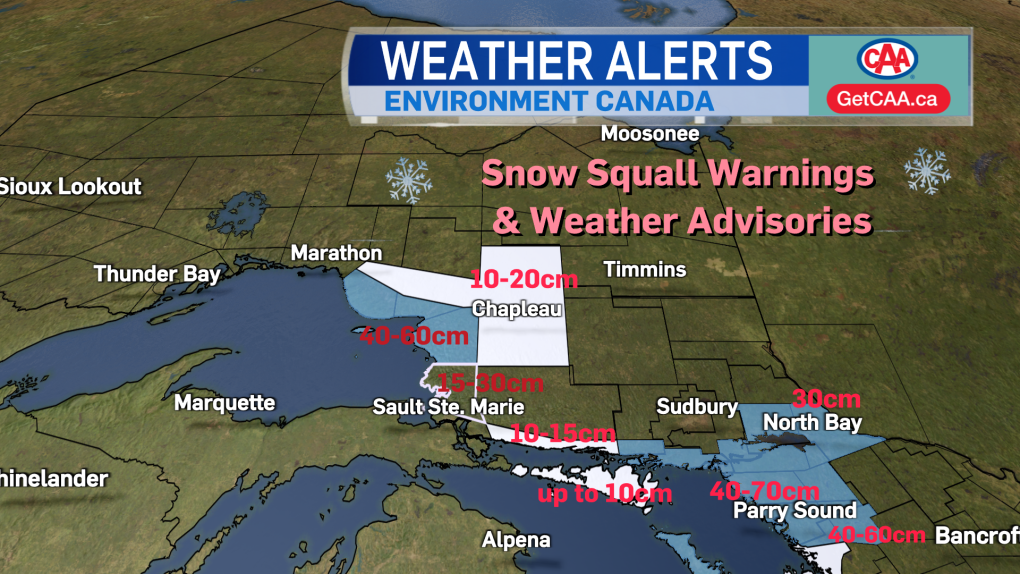 Northeastern Ontario weather alert map as of 11 a.m. Jan. 16/24 (Iselle Slome/CTV Northern Ontario)
Environment Canada is asking travellers to consider postponing non-essential travel until conditions improve.
"Visibility will be suddenly reduced to near zero at times in heavy snow and blowing snow. Rapidly accumulating snow could make travel difficult over some locations," the weather alerts said.
"Prepare for quickly changing and deteriorating travel conditions. If visibility is reduced while driving, slow down, watch for tail lights ahead and be prepared to stop."
- Download the CTV News app now
- Get local breaking news alerts
- Daily newsletter with the top local stories emailed to your inbox
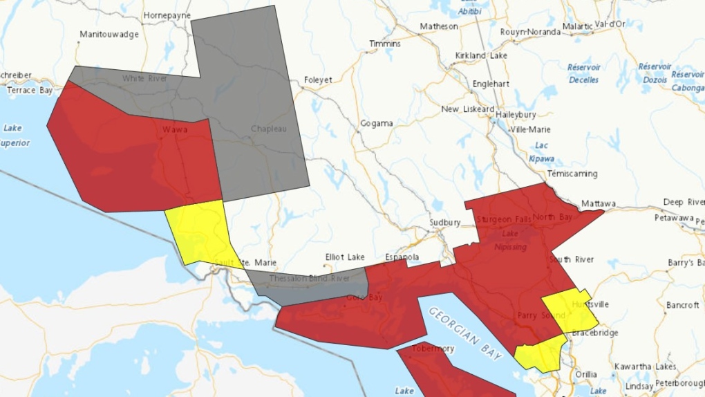 Environment Canada weather alert map for northeastern Ontario (Red - Snow squall warning, Yellow - Snow squall watch, Grey - Winter Weather Travel Advisory) Jan.16/24
SNOW SQUALL WARNINGS (RED)
The Wawa and Pukaskwa Park area will get the most snow with 40 – 60 cm and even higher amounts possibly by Wednesday morning locally.
"A multi-day lake effect snow squall event will affect areas east of Lake Superior today (Tuesday) through Wednesday. Even though the snow squalls will shift with time, road closures are possible due to these significant snowfall accumulations," Environment Canada said Tuesday morning.
"Travel is expected to be hazardous due to reduced visibility … Road closures are likely."
Highway 17 is closed again between Wawa and Batchawana Bay on Tuesday due to weather after being closed for most of Monday.
The snowfall rate for Manitoulin Island on Tuesday is expected to be 10 cm per 12 hours.
"Lake effect snow will affect the eastern portion of Manitoulin Island this morning (Tuesday). The most intense snow band is expected later this afternoon and tonight. It is possible that the lake effect snow may continue into Wednesday," the snow squall warning said.
Espanola and Killarney east to North Bay, Powassan and Mattawa, including West Nipissing and French River should get between five-10 cm of snow.
"Lake effect snow bands from Georgian Bay and Lake Huron are expected to affect portions of the North Bay - Nipissing and Killarney regions. The lake effect bands are expected to shift from time to time, but should persist into Wednesday for some regions," the weather alert said.
Parry Sound and Rosseau east to South River and Burk's Falls should get 15 – 25 cm locally and another 20 – 40 cm Tuesday night and Wednesday.
Peak snowfall rates could be more than five cm/h.
"Snow squalls will likely persist for regions near Georgian Bay through at least Wednesday afternoon with additional significant accumulations expected," the snow squall warning said.
School buses run by Nipissing – Parry Sound Student Transportation Services are cancelled Tuesday in all weather zones.
SNOW SQUALL WATCHES (YELLOW)
Searchmont, Montreal Harbour and Batchawana Bay north of Sault Ste. Marie should see 15 – 30 cm of snow on Tuesday.
"Flurries will continue today (Tuesday); however, the most intense snow squalls are expected to begin tonight and continue on Wednesday," Environment Canada said.
South of Parry Sound along the Georgian Bay, Port Carling, Port Severn and Huntsville can expect to see 30 – 40 cm of possible snow with a peak snowfall rate of two to five cm/h.
WINTER WEATHER TRAVEL ADVISORIES (GREY)
Chapleau and White River should see 10 – 20 cm by Tuesday evening while Blind River and Thessalon along the North Channel could get 10 – 15 cm of snow which could continue Wednesday.
"Lake effect snow off Lake Superior will (be) extended far enough inland to affect portions of Highway 101, northern Chapleau region and near Dubreuilville. It is possible that the lake effect snow may continue into early Wednesday morning over portions of the regions," the weather alert said.
"Motorists should expect hazardous winter driving conditions and adjust travel plans accordingly. Take extra care when walking or driving in affected areas."

Shopping Trends
The Shopping Trends team is independent of the journalists at CTV News. We may earn a commission when you use our links to shop. Read about us.


CTVNews.ca Top Stories

Can the Governor General do what Pierre Poilievre is asking? This expert says no
A historically difficult week for Prime Minister Justin Trudeau and his Liberal government ended with a renewed push from Conservative Leader Pierre Poilievre to topple this government – this time in the form a letter to the Governor General.
'I'm still thinking pinch me': lost puppy reunited with family after five years
After almost five years of searching and never giving up hope, the Tuffin family received the best Christmas gift they could have hoped for: being reunited with their long-lost puppy.
Two U.S. Navy pilots shot down over Red Sea in apparent 'friendly fire' incident, U.S. military says
Two U.S. Navy pilots were shot down Sunday over the Red Sea in an apparent 'friendly fire' incident, the U.S military said, marking the most serious incident to threaten troops in over a year of America targeting Yemen's Houthi rebels.
Big splash: Halifax mermaid waves goodbye after 16 years
Halifax's Raina the Mermaid is closing her business after 16 years in the Maritimes.
OPP find wanted man by chance in eastern Ontario home, seize $50K worth of drugs
A wanted eastern Ontario man was found with $50,000 worth of drugs and cash on him in a home in Bancroft, Ont. on Friday morning, according to the Ontario Provincial Police (OPP).
B.C. mayor gets calls from across Canada about 'crazy' plan to recruit doctors
A British Columbia community's "out-of-the-box" plan to ease its family doctor shortage by hiring physicians as city employees is sparking interest from across Canada, says Colwood Mayor Doug Kobayashi.
It was Grandma, in the cafe with a Scrabble tile: Game cafes are big holiday business
It’s the holidays, which means for many across the Prairies, there’s no better time to get locked in a dungeon with a dragon.
Oysters distributed in B.C., Alberta, Ontario recalled for norovirus contamination
The Canadian Food Inspection Agency has issued a recall due to possible norovirus contamination of certain oysters distributed in British Columbia, Alberta and Ontario.
opinion
opinion Tom Mulcair: Prime Minister Justin Trudeau's train wreck of a final act
In his latest column for CTVNews.ca, former NDP leader and political analyst Tom Mulcair puts a spotlight on the 'spectacular failure' of Prime Minister Justin Trudeau's final act on the political stage.
Barrie
-

Residents startled by blue flashes in the sky during power outage in Barrie
A power outage on Saturday night left over a thousand Barrie homes in the dark.
-
One driver faces several charges following Highway 400 crash in Oro-Medonte
Traffic came to a standstill Friday afternoon following a single-vehicle collision on Highway 400 in Oro-Medonte.
-
High school teacher charged with sexual assault amid allegations involving a student
A 51-year-old teacher from Georgina has been charged with sexual assault following allegations involving a student.
Toronto
-

Cold in Toronto feels like -18 with the wind chill
The frigid weather hanging over Toronto isn’t letting up, and currently feels like -18 with the wind chill.
-
Toronto police investigating 2 separate east-end shootings, no injuries reported
Toronto police are investigating two separate east-end shootings that occurred within 12 hours of each other.
-
Three-vehicle crash leaves 4 people injured in Brampton
Four people were injured in a three-car crash in Brampton early Sunday morning.
Ottawa
-
 BREAKING NEWS
BREAKING NEWS 4 children, 4 adults taken to hospital following ‘potential Carbon Monoxide’ call in Vanier
The Ottawa Paramedic Service says eight people were taken to hospital in serious condition after a "potential Carbon Monoxide" call Sunday morning in the neighbourhood of Vanier.
-
Flooding started, ice still thin: Here’s the latest update about the Rideau Canal Skateway
Preparations to open the Rideau Canal Skateway are underway, as deep freeze continues to linger around Ottawa this weekend.
-
OPP find wanted man by chance in eastern Ontario home, seize $50K worth of drugs
A wanted eastern Ontario man was found with $50,000 worth of drugs and cash on him in a home in Bancroft, Ont. on Friday morning, according to the Ontario Provincial Police (OPP).
Kitchener
-
Can the Governor General do what Pierre Poilievre is asking? This expert says no
A historically difficult week for Prime Minister Justin Trudeau and his Liberal government ended with a renewed push from Conservative Leader Pierre Poilievre to topple this government – this time in the form a letter to the Governor General.
-
Driver in Kitchener charged after going 180km/h in 70km/h zone
A G2 driver has been charged after going 110km over the speed limit in Kitchener Sunday morning.
-
'I'm still thinking pinch me': lost puppy reunited with family after five years
After almost five years of searching and never giving up hope, the Tuffin family received the best Christmas gift they could have hoped for: being reunited with their long-lost puppy.
London
-

We're heading into the busiest time of year for emergency rooms
Medical emergencies don’t take holidays – and it’s important to prepare for anything heading into the holiday season.
-
Dreaming of a white Christmas?
Christmas is right around the corner, and while winter has been touch and go, there’s a good chance that we will not be looking out the window at a winter wonderland this week.
-
Owen Sound to invest half a million in community splashpad and playground
The half a million dollar investment will replace the existing 25 year old playground structure and renew the splashpad – which at 15 years old requires some servicing.
Windsor
-

Dreaming of a white Christmas?
Christmas is right around the corner, and while winter has been touch and go, there’s a good chance that we will not be looking out the window at a winter wonderland this week.
-
If you want to get the kids out of the house over the break, check out these day camps
There’s lots of opportunity to get out in your community and get involved, with camp dates coming up on Monday, Tuesday and Friday this week, and Monday, Tuesday, Thursday and Friday next week.
-
Cancer centre raises $2.7 million for purchase of 'game changer' surgical robot
The Windsor Cancer Centre Foundation has raised a record breaking $2.7 million through the Grow on Windsor Campaign.
Montreal
-

SPVM investigating possible arson attack in Saint-Leonard
Montreal police (SPVM) confirmed that a vehicle was set on fire in the Saint-Leonard borough early Sunday morning.
-
Spill closes Highway 25 near Louis-Hippolyte-La Fontaine Tunnel
A spill forced the closure of Highway 25 northbound Sunday morning at the Hochelaga Street exit, near the Louis-Hippolyte-La Fontaine tunnel in Montreal.
-
Canadiens riding three-game win streak ahead of long stretch away from home
The Montreal Canadiens are on a season-best win streak ahead of their longest stretch away from home. Patrik Laine scored on the power play, again, and the Montreal Canadiens defeated the Detroit Red Wings on consecutive nights with a 5-1 victory Saturday.
Winnipeg
-

Muslim youth group distributes meals to Winnipeg's most vulnerable
In the spirit of giving season, a Muslim youth group made its way through the city’s downtown distributing meals to those in need.
-
'Good deals for Christmas': Turkey prices down from last year
With just days to go before Christmas, one of the big items for the big feast could be cheaper this year. Numbers from Agriculture and Agri-Food Canada show that during November this year, turkey prices were down from the same time last year.
-
Ace Burpee's Top 100 Most Fascinating Manitobans of 2024
It’s been another year of Manitobans doing interesting, incredible and cool things. The hardest part of compiling this list is cutting it off at 100.
Atlantic
-

'On death row.' Wrongfully convicted N.B. man has mixed feelings since exoneration
Robert Mailman, 76, was exonerated on Jan. 4 of a 1983 murder for which he and his friend Walter Gillespie served lengthy prison terms.
-
Cape Breton police arrest second person in missing man investigation
A second person has been arrested in the disappearance of Justin MacDonald in Cape Breton.
-
Icy conditions persist, parking ban lifted in Halifax
Halifax has lifted a parking ban for Zone 1 – Central and Zone 2- Non-Central that was enforced Friday and Saturday night to accommodate snow removal following a winter storm.
N.L.
-

Newfoundland woman washed sick patients' hair every Saturday for more than 20 years
A retired nurse and teacher in Newfoundland was honoured this week for her volunteer work, which included more than two decades washing the hair of bedridden hospital patients.
-
Newfoundland man facing more charges related to youth sex crimes
A 64-year-old Newfoundland man charged with dozens of sex crimes involving young people is facing several new charges.
-
After fanfare of Churchill Falls deal, Newfoundland urged to learn its dam lessons
Energy observers in Newfoundland and Labrador are urging the provincial government to take a sober second look at a massive tentative deal announced last week with Quebec that promises to deliver hundreds of billions of dollars in revenue to the Atlantic province.
Calgary
-
It was Grandma, in the cafe with a Scrabble tile: Game cafes are big holiday business
It’s the holidays, which means for many across the Prairies, there’s no better time to get locked in a dungeon with a dragon.
-
Traffic advisory issued by RCMP due to poor driving conditions south of Calgary and north of Red Deer
Alberta RCMP issued a traffic advisory early Sunday morning due to poor driving conditions throughout the province.
-
Flames get goals from 6 players in a 6-4 victory over the Blackhawks
Jonathan Huberdeau, Connor Zary, Blake Coleman, and Matt Coronato each had a goal and an assist as the Calgary Flames beat the Chicago Blackhawks 6-4 on Saturday.
Edmonton
-

'There’s no support': Domestic abuse survivor shares difficulties leaving her relationship
An Edmonton woman who tried to flee an abusive relationship ended up back where she started in part due to a lack of shelter space.
-
Oilers finding ways to thrive in close encounters
Leon Draisaitl scored 18 seconds into overtime to extend his point streak to eight games as the Edmonton Oilers overcame a slow start to win their second straight game in extra time, defeating the San Jose Sharks 3-2 on Saturday.
-
It was Grandma, in the cafe with a Scrabble tile: Game cafes are big holiday business
It’s the holidays, which means for many across the Prairies, there’s no better time to get locked in a dungeon with a dragon.
Regina
-

Gathering held in Regina to recognize Winter Solstice
Regina's mâmawêyatitân centre held a day of gathering for the Winter Solstice on Saturday.
-
Canada's first sustainable Tim Hortons location to open in Regina this weekend
Canada’s first sustainable Tim Hortons opens in Regina this weekend. The restaurant, located in the city’s east end, features design and operating features that minimize environmental impact.
-
Gravelbourg's transportation program celebrates addition of new vehicle and garage
The town of Gravelbourg is celebrating the addition of a new vehicle and garage which will be used in their local transportation program.
Saskatoon
-
Sask. police investigating mischief incident after bomb report in school
Prince Albert police are investigating a mischief incident after a bomb report in a school Friday afternoon.
-
Prince Albert woman collects donations to make Christmas hampers for community
A Prince Albert woman is spreading holiday cheer by organizing Christmas hampers for those in need.
-
Sask. lawyers defend judge for staying fatal THC-impaired driving charge
The Saskatchewan Trial Lawyers Association is defending a provincial court judge, who’s facing backlash for staying a charge in a high-profile case involving the death of a child.
Vancouver
-

Drug superlabs leave a toxic mess. Some say B.C.'s cleanup rules are a mess, too
As clandestine drug labs become larger and more complex, so does the toxic mess they leave behind and the tools required to clean them up, creating expensive and dangerous situations for both people and the environment.
-
'We need to win': Vancouver Canucks battling frustration amid slump
Frustration is beginning to creep in for the Vancouver Canucks.
-
Can the Governor General do what Pierre Poilievre is asking? This expert says no
A historically difficult week for Prime Minister Justin Trudeau and his Liberal government ended with a renewed push from Conservative Leader Pierre Poilievre to topple this government – this time in the form a letter to the Governor General.
Vancouver Island
-
Drug superlabs leave a toxic mess. Some say B.C.'s cleanup rules are a mess, too
As clandestine drug labs become larger and more complex, so does the toxic mess they leave behind and the tools required to clean them up, creating expensive and dangerous situations for both people and the environment.
-
B.C. mayor gets calls from across Canada about 'crazy' plan to recruit doctors
A British Columbia community's "out-of-the-box" plan to ease its family doctor shortage by hiring physicians as city employees is sparking interest from across Canada, says Colwood Mayor Doug Kobayashi.
-
B.C. woman with photographic memory strives to make unforgettable Christmas displays
Although Alisha Pauling is looking through old pictures, she doesn’t need them to remember her Christmases past. She has a photographic memory.


