Winter weather travel advisory, up to 20 cm of snow in parts
Snow is on the way, Environment Canada issued a winter weather travel advisory for several communities in northern Ontario on Monday. More winter weather travel advisories issued Wednesday in the northeast.
Temperatures across northeastern Ontario have dropped and some communities are expecting snow as a "very slow-moving low-pressure system will bring precipitation to the area for the next few days."
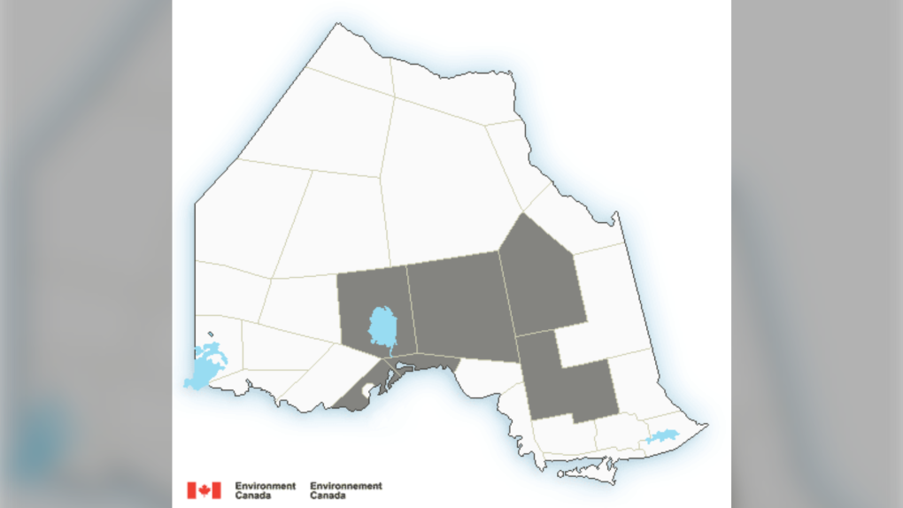 Environment Canada weather alert map Oct. 17/22
Here is where the snow is expected to fall and how much.
These communities could see 10 to 20 centimetres of snow by Tuesday morning, with the majority expected to fall Monday:
- Aroland, Hornepayne, Manitouwadge, Nakina and Pagwa
- Fraserdale, Hearst, Kapuskasing, Pledger Lake and Smooth Rock Falls
Chapleau and Missinaibi Lake could see five to 15 centimetres of snow, with most falling Monday night and ending Tuesday morning.
Beardmore, Black Sturgeon Lake, Cloud Bay, Dorion, Gull Bay, Jellicoe, Macdiarmid, Nipigon and Rossport could see accumulations between five and 10 centimetres as lake effect flurries continue into the early afternoon.
"Snow will become heavy at times today and taper off Tuesday morning," Environment Canada said.
"Motorists should expect hazardous winter driving conditions and adjust travel plans accordingly. Take extra care when walking or driving in affected areas. If visibility is reduced while driving, turn on your lights and maintain a safe following distance. Visibility may be suddenly reduced at times in heavy snow."
Meanwhile, the four major cities in the northeast – Greater Sudbury, North Bay, Sault Ste. Marie and Timmins – should see rain and single-digit highs, with low temperatures hovering just above freezing.
Top Stories
-
-
-
 ANALYSIS
ANALYSIS Why are Trudeau and Singh avoiding Stampede this year?
-
-
-
-
-


CTVNews.ca Top Stories

Woman dies at Rolling Stones concert in Vancouver
A woman attending the Rolling Stones concert at BC Place died Friday night, police confirmed.
Terrorism charges laid against B.C. woman who married ISIS fighter
A B.C. woman who was repatriated from a Syrian prison camp in 2022 has been arrested and charged with terrorism offences, police announced Saturday.
This Italian vacation hotspot is turning tourists away as it runs out of water
Set atop a hill on the Italian island of Sicily, Agrigento is a heritage tourist’s paradise. But the aqueduct, and others built in modern times, are running so dry that small hotels and guesthouses in the city and nearby coast are being forced to turn tourists away.
Jon Landau, Oscar-winning 'Titanic' and 'Avatar' producer, dies at 63
Jon Landau, an Oscar-winning producer who worked closely with director James Cameron on three of the biggest blockbusters of all time, 'Titanic' and two 'Avatar' films, has died. He was 63.
Radio host who interviewed Biden says aides provided questions in advance
U.S. President Joe Biden’s team provided a list of questions to a radio host who interviewed the president this week in the aftermath of his debate performance, the host told CNN.
ANALYSIS
ANALYSIS Why are Trudeau and Singh avoiding Stampede this year?
This year, only Conservative leader Pierre Poilievre will be saddling up for the event, while both Prime Minister Justin Trudeau and NDP leader Jagmeet Singh will stay away.
Here are some safety tips if you're travelling alone this summer
Though travelling by yourself can be scary and intimidating, there are some ways to make sure you’re safe and have a good time, says a solo travel and content creator from Ottawa.
Saskatoon man charged for leaving hate comments on woman’s obituary pleads guilty
The man who left hate comments on a murder victim’s online obituary has been sentenced.
Alleged accomplice of Quebec gang leader Dave 'Pic' Turmel arrested in B.C.
Another alleged accomplice of the leader of the Blood Family Mafia (BFM), Dave 'Pic' Turmel, has been arrested by the RCMP.
Shopping Trends
The Shopping Trends team is independent of the journalists at CTV News. We may earn a commission when you use our links to shop. Read about us.


Barrie
-

Irish Mythen, Noah Cyrus headline Mariposa Day 2
The Irish-Canadian folk artist and Billy Ray Cyrus' youngest daughter take the stage Saturday night at the Mariposa Folk Festival.
-
Bradford African festival showcases culture, food, community
The African Experience welcomed hundreds to the Bradford West Gwillimbury Public Library for a celebration of Black and African culture.
-
Local great-grandmother celebrates 100th birthday
Mary Buratynsky celebrated her centurion birthday with family and friends in Springwater on Saturday afternoon.
Toronto
-

Stabbing in Mississauga school parking lot leaves woman dead; one person in custody
A woman is dead, and a man is in custody after a stabbing outside a school in Mississauga.
-
Gold from Toronto Pearson heist likely in India or Dubai: police
Police believe that the majority of gold stolen from Toronto Pearson International Airport in 2023 has been smuggled, sold and melted overseas.
-
Injunction to keep Toronto's Revue Cinema open extended to October
An injunction standing between the Revue Cinema and possible eviction has been extended to the fall, the group that operates the historic theatre in Toronto’s west end announced Friday.
Ottawa
-

Ottawa man using walker says apartment not accessible, with no answer in sight
An Ottawa man living in the city’s south-end says he’s struggling to get his walker through the front door of his apartment and wants the building’s owner to install an automatic door button.
-
Ottawa man, 28, dead after shooting in Westboro, police investigating
The Ottawa Police Service is investigating following a shooting that left one man dead Friday in Westboro.
-
Stunt driver caught speeding nearly 90 km/h over speed limit in Barrhaven
The Ottawa Police Service clocked a driver speeding to nearly 90 km/h over the posted speed limit in Barrhaven on Friday night as police continue to target high-risk drivers in the city.
Kitchener
-
Occupy UW agrees to end encampment, University of Waterloo to withdraw injunction
The pro-Palestinian encampment that's been on the University of Waterloo's campus for nearly two months is expected to be gone by Sunday evening.
-
Southwestern Ont. alpaca farmers call for more wool processing resources in province
Southwestern Ontario alpaca farmers are calling for more wool processing resources in the province.
-
How local alcohol businesses are reacting to LCBO strike
Locally-owned alcohol businesses are making adjustments to attract more customers while LCBO workers across the province are on strike.
London
-

Amid threat from Western University, protesters remove encampment after two months
After threats by Western University to dismantle before the end of the weekend, the pro-Palestine encampment on campus has come down.
-
VIDEO: Three businesses damaged in Kincardine fire
A fire has caused extensive damage to at least three businesses in Kincardine Saturday morning.
-
Police continue search for missing man on two-year anniversary
The Sarnia Police Service (SPS) continues its search for a man who has been missing for two years.
Windsor
-

Harrow family of four died from gunshot wounds in case of intimate partner violence, OPP say
Investigators have determined that the deaths of four family members in Harrow in June were the result of intimate partner violence, with three dying from gunshot wounds and one from a self-inflicted gunshot wound.
-
Police reveal Windsor's most collision-prone intersection in last 15 months
In the last 15 months, the stretch of road in front of Devonshire Mall leading to the E.C Row Expressway ramps has become the most collision-prone area for drivers in Windsor.
-
VIDEO
VIDEO Local pizza maker nominated for world's 100 best wants Windsor 'at the table' with New York and Chicago pizza
After earning awards for Canada's best pizza chef in Canada and top-five positions in competitions across North America, Dean Litster is in the running to be recognized on an international stage.
Montreal
-

Quebec pharmacists may soon have more powers: What are they?
Pharmacists in Quebec can treat certain minor health problems or offer preventative treatments.
-
Montreal police make 1 arrest, deploy tear gas after protesters smash windows at McGill
One person was arrested Friday evening after police deployed tear gas to disperse a crowd of pro-Palestinian protesters at McGill University.
-
Alleged accomplice of Quebec gang leader Dave 'Pic' Turmel arrested in B.C.
Another alleged accomplice of the leader of the Blood Family Mafia (BFM), Dave 'Pic' Turmel, has been arrested by the RCMP.
Winnipeg
-

Have you seen Johnny? WPS search for 24-year-old man
The Winnipeg Police Service (WPS) is asking for the public’s help in finding 24-year-old Johnny Arragutainaq.
-
The story behind a truck covered in teacups in Brandon
If you’re ever visiting Brandon, Man., you might want to pay a visit to Talia. She’s beautiful, delicate, and a true work of art.
-
Winnipeg man faces over 20 charges in stolen vehicle, property investigation
A Winnipeg man is facing more than 20 charges after an off-duty RCMP officer discovered a stolen vehicle parked in front of a home in the city’s Brooklands neighbourhood.
Atlantic
-

Picture-perfect greens on display at Mactaquac as organizers prepare for PGA Tour Americas tournament
It's an orchestra of lawn trimmers, mowers and golf carts at Mactaquac Provincial Park as organizers prepare to welcome over 150 professional golfers to their greens for the PGA Tour Americas.
-
Cavendish Beach Music Festival continues rain or shine
The largest multi-day outdoor music festival in Atlantic Canada has officially kicked-off, with some of the biggest names in country music visiting our region.
-
N.B. man dead after Jet Ski and recreational boat collision in Petit-Tracadie
New Brunswick RCMP says a man has died following a collision between a Jet Ski and recreational boat on the Tracadie River in Petit-Tracadie.
N.L.
-

Church must pay $104 million to victims of historical abuse in Newfoundland
The Roman Catholic Church has been ordered to pay settlements totalling $104 million to 292 survivors of historical abuse in Newfoundland and Labrador, including those at the now infamous Mount Cashel orphanage in St. John's.
-
Human remains backlog still in Newfoundland garage after months of outcry
Opposition parties in Newfoundland and Labrador say they’re growing frustrated at the decision by health officials to move freezers of unclaimed human remains into an underground hospital parking garage.
-
Newfoundland and Labrador premier takes aim at Ottawa over reopened cod fishery
Newfoundland and Labrador's Liberal premier is once again opposing a decision made by the federal Liberals — this time about the reopening of the province's commercial northern cod fishery.
Calgary
-

Calgarians allowed to water by hand, some pools open as city eases outdoor restrictions
Calgary is easing outdoor water restrictions as the city continues work to help its water infrastructure recover following a major feeder main break.
-
Newly renamed 'Cowboys Park' in west downtown will host annual Stampede music festival
Calgary is renaming a popular park in the west end of downtown with the goal of revitalizing the area as an event space, to host an annual Stampede music festival and more.
-
ANALYSIS
ANALYSIS Why are Trudeau and Singh avoiding Stampede this year?
This year, only Conservative leader Pierre Poilievre will be saddling up for the event, while both Prime Minister Justin Trudeau and NDP leader Jagmeet Singh will stay away.
Edmonton
-

2 firms offering auto insurance to pull out of Alberta market
Two insurance providers in Alberta have announced plans to stop offering automobile insurance to customers in the province.
-
Serious crash affects traffic on Highway 43 in Grande Prairie
Traffic on Highway 43 in Grande Prairie was affected by a serious crash Saturday afternoon.
-
Mill Creek pool rehabilitated and ready to reopen after 4 years
Mill Creek Pool will reopen Monday after more than four years.
Regina
-

Three people dead in 2 vehicle collision in Sask.
Three people are dead following a collision between a truck and a van on Highway 4 near Cochin, Sask. on Friday.
-
Woman and child killed and four injured in Sask. Highway 4 collision
Two people have died and four people were injured in a fatal collision on Highway 4 on Friday.
-
Car enthusiasts gather to bid on collector vehicles at annual weekend auction
Coast2Coast Collector Car Auctions held their fourth annual car auction event Saturday.
Saskatoon
-

Woman and child killed and four injured in Sask. Highway 4 collision
Two people have died and four people were injured in a fatal collision on Highway 4 on Friday.
-
Three people dead in 2 vehicle collision in Sask.
Three people are dead following a collision between a truck and a van on Highway 4 near Cochin, Sask. on Friday.
-
Saskatoon man charged for leaving hate comments on woman’s obituary pleads guilty
The man who left hate comments on a murder victim’s online obituary has been sentenced.
Vancouver
-

Terrorism charges laid against B.C. woman who married ISIS fighter
A B.C. woman who was repatriated from a Syrian prison camp in 2022 has been arrested and charged with terrorism offences, police announced Saturday.
-
Woman dies at Rolling Stones concert in Vancouver
A woman attending the Rolling Stones concert at BC Place died Friday night, police confirmed.
-
Vancouver cooling centres opened as heat wave hits B.C.
Cooling centres in Vancouver opened Saturday as B.C. began to experience its first widespread heatwave of the summer.
Vancouver Island
-
Terrorism charges laid against B.C. woman who married ISIS fighter
A B.C. woman who was repatriated from a Syrian prison camp in 2022 has been arrested and charged with terrorism offences, police announced Saturday.
-
Whale researcher says orphan orca 'likely' seen off Vancouver Island at Friendly Cove
A killer whale calf whose struggle for survival captured international headlines when she became trapped in a Vancouver Island tidal lagoon earlier this year only to escape on her own has likely been spotted swimming further south along British Columbia's coast.
-
B.C. heat wave may increase wildfire activity but reduce lightning starts: BCWS
As sweltering heat sets in over much of British Columbia, the province's wildfire authority is warning that dry conditions will increase the potential for wildfire activity.


