Winter storm expected Tuesday with up to 30 cm of snow
Most of northeastern Ontario is under a winter storm watch as a strong weather system approaches the region and is expected to bring 15 to 30 centimetres of snow by Wednesday morning.
The storm is expected to begin late Tuesday afternoon and taper off Wednesday morning, the Environment Canada weather alert said.
"Northeast winds gusting up to 60 km/h will result in areas of blowing snow giving poor visibility at times," the alert said.
"The exact track of this weather system is still somewhat uncertain, and as a result, expected snowfall amounts may change."
Sault Ste. Marie and communities east to the Quebec border – including Manitoulin Island and Parry Sound – are affected.
Foleyet, Gogama and Kirkland Lake are also under the winter storm watch, while Timmins and the communities north along the Highway 11 corridor are not and may not receive as much snow.
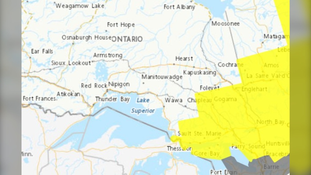 Environment Canada weather alert map Jan. 8/24 (Winter Storm Watch in yellow, Special Weather Statement in grey)
"Travel is expected to be hazardous due to reduced visibility in some locations. Surfaces such as highways, roads, walkways and parking lots may become icy and slippery," Environment Canada said.
"Poor weather conditions may contribute to transportation delays."
There is also a risk of freezing rain and ice pellets in the Burk's Falls – Bayfield Inlet area Tuesday night with a possibility of rain in areas near Georgian Bay.
CTVNewsNorthernOntario.ca will continue to monitor the developing situation and provide updates.
READ: Weather alert upgraded to a winter storm warning Tuesday morning, some school buses cancelled.
Shopping Trends
The Shopping Trends team is independent of the journalists at CTV News. We may earn a commission when you use our links to shop. Read about us.


CTVNews.ca Top Stories

'Mayday! Mayday! Mayday!': Details emerge in Boeing 737 incident at Montreal airport
New details suggest that there were communication issues between the pilots of a charter flight and the control tower at Montreal's Mirabel airport when a Boeing 737 made an emergency landing on Wednesday.
Trudeau appears unwilling to expand proposed rebate, despite pressure to include seniors
Prime Minister Justin Trudeau does not appear willing to budge on his plan to send a $250 rebate to 'hardworking Canadians,' despite pressure from the opposition to give the money to seniors and people who are not able to work.
Hit man offered $100,000 to kill Montreal crime reporter covering his trial
Political leaders and press freedom groups on Friday were left shell-shocked after Montreal news outlet La Presse revealed that a hit man had offered $100,000 to have one of its crime reporters assassinated.
Cucumbers sold in Ontario, other provinces recalled over possible salmonella contamination
A U.S. company is recalling cucumbers sold in Ontario and other Canadian provinces due to possible salmonella contamination.
Trudeau says no question incoming U.S. president Trump is serious on tariff threat
Prime Minister Justin Trudeau says incoming U.S. president Donald Trump's threats on tariffs should be taken seriously.
In a shock offensive, insurgents breach Syria's largest city for the first time since 2016
Insurgents breached Syria's largest city Friday and clashed with government forces for the first time since 2016, according to a war monitor and fighters, in a surprise attack that sent residents fleeing and added fresh uncertainty to a region reeling from multiple wars.
Canada Bread owner sues Maple Leaf over alleged bread price-fixing
Canada Bread owner Grupo Bimbo is suing Maple Leaf Foods for more than $2 billion, saying it lied about the company's involvement in an alleged bread price-fixing conspiracy.
Musk joins Trump and family for Thanksgiving at Mar-a-Lago
Elon Musk had a seat at the family table for Thanksgiving dinner at Mar-a-Lago, joining President-elect Donald Trump, Melania Trump and their 18-year-old son.
Here's how thick ice needs to be to park a truck on it, according to Sask. Water Security Agency
The Saskatchewan Water Security Agency (WSA) says ice should be at least one foot (30 centimetres) thick before it's safe to drive a car or light truck on a frozen body of water.
Barrie
-

50 cm of snow across central Ontario expected this weekend
Environment Canada has released snow squall warnings and watches for our region.
-
Alleged mastermind behind Ontario woman's presumed death seeks bail
The man facing first-degree murder and kidnapping charges in the disappearance of Ontario woman Elnaz Hajtamiri took another shot at bail on Friday in a Barrie courtroom. Mohamad Lilo, 37, has been behind bars since his arrest more than two years ago.
-
Individuals living in encampment in Barrie's south end given notice to vacate
Several police officers and city staff attended a homeless encampment in Barrie’s south end on Thursday morning to inform the individuals living there they would have to vacate the area.
Toronto
-
 BREAKING
BREAKING Feds announce $758 million in funding for new Line 2 TTC subway trains
The TTC will get funding from the federal government to replace aging trains on Line 2, Deputy Prime Minister Chrystia Freeland has announced.
-
Highway 407 owner says no active buyback discussions with Ontario government
The provincial government is facing increasing pressure to tap into the underused and tolled Highway 407 to alleviate congestion on Highway 401.
-
Officer's inaccurate testimony 'will undoubtedly tarnish the image of the Toronto Police Service:' police tribunal
A Toronto cop who 'derailed' a criminal investigation by 'inaccurately' testifying that he saw drugs in plain view inside a suspect’s car has been demoted for two years after pleading guilty to discreditable conduct, a decision from the police tribunal read.
Ottawa
-

Next big test for the LRT south extension taking place Saturday
Five hundred people will be riding on Lines 2 and 4 Saturday, to simulate passenger service in a 'dress rehearsal' that marks the next major step before the delayed south extension can open to the public.
-
Ottawa police charge two adults, teenager following Orleans kidnapping and robbery
The Ottawa Police Service says two adults and a teenager are facing multiple charges following a kidnapping, robbery and extortion incident that happened last month in Orleans.
-
'Dude, Where's My Bus?' Ottawa man fed up with OC Transpo makes documentary exploring transit troubles
Gio Petti put together a documentary on OC Transpo, asking how we got here. How did a city that was once lauded as an example of how to do transit right, and that boasted some of the highest per capita transit ridership numbers in the country, become a system that now elicits so much frustration from users?
Kitchener
-

Erick Buhr to represent himself during sentencing for second-degree murder in death of his grandmother, Viola Erb
Erick Buhr will represent himself as he prepares for sentencing after being convicted of second-degree murder in the death of his grandmother, Viola Erb.
-
Man accused of involvement in massive data breach appears in Kitchener court
The man accused of being behind a massive data breach impacting several large U.S. companies made a brief appearance in Kitchener court Friday.
-
Cucumbers sold in Ontario, other provinces recalled over possible salmonella contamination
A U.S. company is recalling cucumbers sold in Ontario and other Canadian provinces due to possible salmonella contamination.
London
-

Crown witness describes chaotic night after bush party shooting
Crown witness Reece Davidson, 21, told the jury that he was at the bush bash off of Pack Road in southwest London with a bunch of his young friends on July 30, 2021.
-
'The only thing you could see were his eyes': Employees pepper sprayed at south London business
Around 4 p.m. on Thursday, police were called to a report of an assault in progress at a business int he 600 block of Wilkins St. near Wellington Road.
-
Digging out from snow squalls in Bruce County
It’s a day for digging in Bruce County. School buses across Bruce and Grey counties were cancelled Friday due to snowsqualls that dumped as much as 15 centimetres of snow on the region overnight.
Windsor
-
 Breaking
Breaking Guilty on all counts: Windsor man convicted of careless driving in Retrofest double fatal collision
The Windsor man charged in connection to the double fatal Retrofest collision has been convicted on all counts.
-
Suspect breaks into home, steals keys and drives off: WPS
Windsor police are asking for help identifying a suspect who allegedly broke into a home, stole keys and drove off with the vehicle.
-
$4,000 in products reported stolen from storage container
Chatham-Kent police are looking for suspects after $4,000 in products were stolen from a storage container in Chatham.
Montreal
-

Hit man offered $100,000 to kill Montreal crime reporter covering his trial
Political leaders and press freedom groups on Friday were left shell-shocked after Montreal news outlet La Presse revealed that a hit man had offered $100,000 to have one of its crime reporters assassinated.
-
Nunavik police working to 'rebuild trust' after Inuk man killed by officer
After police shot and killed a 21-year-old Inuk man and seriously injured his twin brother, Nunavik police are trying to “rebuild trust” with the community.
-
'Mayday! Mayday! Mayday!': Details emerge in Boeing 737 incident at Montreal airport
New details suggest that there were communication issues between the pilots of a charter flight and the control tower at Montreal's Mirabel airport when a Boeing 737 made an emergency landing on Wednesday.
Winnipeg
-

Family says B.C. man's cremated remains in limbo due to Canada Post strike
A Quebec woman whose father died in British Columbia last month says her family has been unable to properly grieve because the Canada Post strike has left his remains in limbo.
-
IIU looking for witness of fatal officer-involved shooting
Manitoba's police watchdog is looking for a person they say witnessed an officer-involved shooting that killed one person.
-
Grant Park High School students sewing class threads the needle with compassion
As temperatures continue to plunge outside, sewing class students at Grant Park High School are threading the needle to help Winnipeg residents stay warm during our cold winter.
Atlantic
-

Suspect taken into custody after weapons complaint at Halifax high school
A suspect has been taken into custody after a high school in Halifax was placed in hold and secure Friday morning.
-
Teen arrested in connection with weapons call at Fredericton High School
Fredericton Police Force arrested a 14-year-old boy Thursday in relation to a weapons call at Fredericton High School.
-
P.E.I. steps in to help buy mobile park to allow residents to stay in homes
Residents of Evergreen Village mobile home park in Summerside, P.E.I., who have had an eviction notice looming over their heads may be able to stay in their homes after all.
N.L.
-

Newfoundland's LGBTQ2S+ bar paid drag queens $37.50. Tara Nova called them out.
If the screaming crowd in the twinkling Majestic Theatre in downtown St. John's was any indication, Newfoundland drag queen Tara Nova will never have to accept $37.50 for a show again.
-
'Who profits on hunger?': Inuit send pleading emails to minister about food costs
People in Nunavut and northern Labrador have been writing to Canadian government officials this year to say grocers were charging exorbitant prices despite receiving a federal subsidy.
-
As N.L. firm pivots, scientists say Canada's green hydrogen dreams are far-fetched
A Newfoundland energy company's embrace of data centres is raising doubts about eastern Canadian hopes of harnessing the region's howling winds to supply Germany with power from green hydrogen.
Calgary
-

Calgary fighters thankful to enter ring under safe conditions after Ultra Boxing event cancelled
A group of Calgary fighters are thankful to be able to enter the ring under a properly sanctioned event this weekend after the organization they were training under was suspended by Boxing Alberta for two years due to safety concerns.
-
Calgary Mayor Jyoti Gondek running for re-election
Calgary Mayor Jyoti Gondek has announced she will run for re-election in the next municipal election in 2025.
-
Cucumbers sold in Ontario, other provinces recalled over possible salmonella contamination
A U.S. company is recalling cucumbers sold in Ontario and other Canadian provinces due to possible salmonella contamination.
Edmonton
-

Machete used to kill Edmonton man may have been picked up by passerby: police
Police are searching for the weapon used to kill an Edmonton man last month.
-
Pedestrian hospitalized after Friday morning crash in central Edmonton
A woman is in hospital with serious injuries after a crash on Friday morning.
-
'It's life-changing': Couple's first Mighty Millions Lottery win is the grand prize
Several people are celebrating after winning big in the Stollery Children's Hospital Foundation's Mighty Millions Lottery.
Regina
-

Regina's LED volume wall leaving Sask. months after opening
Less than a year after an LED volume wall was introduced to the film world in Saskatchewan, the equipment is making its exit from the province.
-
Sask. NDP says Scott Moe, staff stayed in Toronto hotel at rate over $800 per night
The Saskatchewan NDP says Premier Scott Moe and three Saskatchewan Party staff members stayed at a hotel in Toronto last June that cost each of them $818.74 per night for a three-night stay.
-
Jury sequestered to find verdict in sexual assault trial against Regina chiropractor
Justice Janet McMurtry sequestered a 12-person jury to determine a verdict against Regina-based chiropractor Ruben Manz.
Saskatoon
-

'A huge value addition': Sask. scientists develop way to make canola meal more profitable
Researchers at the University of Saskatchewan are looking at making the canola crop more profitable.
-
'Due to the temperatures, we are concerned': RCMP seek tips finding missing elderly man
Saskatchewan RCMP are asking property owners in the rural area in the RM of Laird to check farm outbuildings or sheds in their area for a missing 60-year-old man.
-
Alberta man dies in crash with semi on Sask. highway
A 61-year-old Alberta man has died following a two-vehicle crash on Highway 14 near Landis on Thursday.
Vancouver
-

Suspect arrested after tense incident near Surrey school, police say
Police in Surrey say they called in the heavily armed Emergency Response Team to arrest a man who allegedly had a gun Friday morning.
-
Study of 2023 Okanagan wildfires recommends limiting development in high-risk areas
A study into the devastating wildfires that struck British Columbia's Okanagan region in 2023 has recommended that government and industry limit development in high-fire-risk areas.
-
Man facing 10 charges after Richmond, B.C., crime spree
A Metro Vancouver man has been charged with nine counts of breaking and entering and one count of mischief after a five-day crime spree last November.
Vancouver Island
-

Winter storm watch issued as snow, heavy rain expected for B.C. coast
A winter storm is moving over British Columbia's coast, bringing strong winds, heavy snow and freezing rain as snowfall warnings continue for much of the province's Interior.
-
Police renew appeal for information 12 years after Victoria woman's disappearance
On the anniversary of her disappearance, police in Victoria renewed their appeal for information in Emma Fillipoff’s 12-year-old missing persons case.
-
Man facing 10 charges after Richmond, B.C., crime spree
A Metro Vancouver man has been charged with nine counts of breaking and entering and one count of mischief after a five-day crime spree last November.


