Wildfire west of Sudbury prompts evacuation order, total active fires in northern Ont. grows to 54
A northern Ontario forest fire that started west of Sudbury on Sunday morning has grown to more than 1,000 hectares and has prompted officials to issue an evacuation order for the immediate area as the number of active fires in the region grows.
Sudbury 17 is a wildfire that is located between RR810 and Mississagi Provincial Park and is not under control, the Ontario Ministry of Natural Resources said.
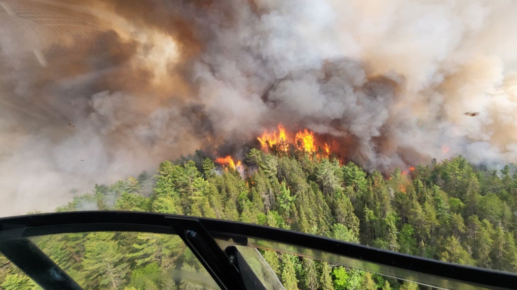 Sudbury 17, located about two kilometres west of RR810 east of Mississagi Provincial Park, has grown to 335 ha in two days. Aerial suppression happened June 4 and is still not under control. (Ministry of Natural Resources and Forestry)
It is north of the communities of Massey and Elliot Lake west of Sudbury.
"The fire is located north of Madaweson Lake. This fire has exhibited high to extreme fire behaviour, fire crews are conducting values protection and suppression is ongoing," MNRF said.
An emergency area order was declared for the following areas June 5:
"All persons must immediately evacuate the listed areas unless authorized by a travel permit issued by the MNRF:
- All travel and use of Highway 810 (also known as the Massey Tote Rd) north of the 17-mile crossover at UTM Zone 17 E 412333 N 5152544
- All travel and use of Highway 810 (also known as the Massey Tote Rd) south of Ritchie Falls at UTM Zone 17 E 403379 N 5177353
Wednesday evening, the evacuation area was expanded to:
"The townships of Olinyk, Plourde (south half), Prescott, Redden (west half), Strain, Teasdale, Poncet, Lehman, Lockeyer, Gerow and Gaiashik, unless authorized by a travel permit issued by the Ministry of Natural Resources and Forestry;
Specifically, all travel and use of Highway 553 (also known as the Massey Tote Rd) south of Cameron Creek at UTM Zone 17 E 408201 N 5136071, as outlined on the attached Implementation Order map within the EAO.
All travel and use of Pecors Rd at the Joubin, Gaiashik Township boundary at UTM Zone 17 E 389417 N 5136617, as outlined on the attached Implementation Order map within the EAO
All persons are prohibited from entering the area indicated on the attached map unless authorized by a travel permit issued by the Ministry of Natural Resources and Forestry."
Facing evacuations due to a forest fire or flood? Here's what to pack in a grab-and-go bag
All travel and use of the following areas is prohibited unless authorized by a travel permit issued by the Sudbury District MNRF:
- Highway 810 (also known as the Massey Tote Rd) north of the 17-mile crossover at UTM Zone 17 E 412333 N 5152544
- Highway 810 (also known as the Massey Tote Rd) south of the Ritchie Falls at UTM Zone 17 E 403379 N 5152544
- John’s Creek Rd at Porter Cree at UTM Zone 17 E 446601 N 5145635
- Fox Lake Rd at Centre Creek at UTM Zone 17 E 446870 N 5162934," the MNRF said.
Download our app to get local alerts on your device
Get the latest local updates right to your inbox
Travel, use and access restrictions put in place under an implantation order by the MNRF for the Hearst-Cochrane-Kapuskasing area on Saturday were expanded at 7 a.m. Tuesday.
Restrictions that were put in place May 31 in the Chapleau-Wawa area due to the Wawa 3 fire near White River are continuing.
FOREST FIRE UPDATE
As of Wednesday morning, the number of active forest fires in northern Ontario has reached 54 with 10 new wildfires Tuesday. Thirty of those active fires are not under control, an increase of seven from Tuesday.
There are 33 active forest fires in the northeast and 21 in the northwest.
In the last 24 hours, five new fires started in the northeast and seven started in the northwest.
The largest new fire in the northeast is Hearst 5 at 90 ha and it is not under control.
"The fire is located 36 kilometers south of Highway 11 and just north of Macvicar Creek," MNRF said Tuesday night.
There are 10 active fires in the northeast that are 100 ha or more:
- Wawa 3 near White River has grown to 6,678.1 ha
- Cochrane 7 has more than doubled in size in one day and sits at 4,256.4 ha
- Cochrane 6 remains at 1,239 ha
- Sudbury 17 tripled in size to 1,024 ha in one day
- Chapleau 3 grew from 80 ha to 700 ha in one day
- Chapleau 6 remains at 209 ha
- Sudbury 10 grew by more than 50 per cent to 120 ha
- Timmins 7 remains at 120 ha
- Wawa 2 remains at 105 ha and is now under control
Since the first Ontario forest fire April 12, 182 wildfires have started, 128 have been extinguished and more than 37,000 ha have burned.
SMOKE
Heavy smoke conditions continue in the northeast and is affecting the air quality.
"Smoke drift is travelling as far as north of Timmins, down through Sudbury and past Parry Sound," MNRF said.
Forest fire smoke can be harmful to your health, so officials recommend taking precautions to reduce exposure.
"See smoke and are unsure if you should call it in? Generally, if you see a column of smoke, give us a call at 310-FIRE (3473) if you’re located north of the French and Mattawa Rivers (or 911 if you’re south of these rivers); otherwise, check our interactive fire map or the above smoke-related websites to determine if what you’re seeing is drifting heavy smoke," MNRF said.
FIRE BANS IN EFFECT
Many northern Ontario communities have issued municipal fire bans in addition to the regionally restricted fire zone that went into effect June 1.
This prohibits open-air burning, including campfires.
"Portable gas or propane stoves may be used for cooking and warmth but must be handled with extreme caution. All burning permits are suspended," MNRF said.
Failure to comply with the fire ban could result in a fine of up to $25,000, three months in jail and financial responsibility for any costs incurred in fighting a forest fire caused by the illegal blaze.
PLANES AND DRONES
Residents are asked to stay clear of waterbombers that scoop up water from area lakes.
"If you see one flying overhead while fishing or enjoying time on the water, move to shore as safely as possible to allow room for them to perform their scoop," MNRF said on social media.
Officials are also reminding people it is illegal to fly a drone within nine kilometres of a wildfire, as it is dangerous for firefighters and pilots.
More details can be found on the ministry's forest fire page.


CTVNews.ca Top Stories

'State or state-sponsored actor' believed to be behind B.C. government hacks
The head of British Columbia’s civil service has revealed that a “state or state-sponsored actor” is behind multiple cyber-security incidents against provincial government networks.
Here's how much more Canadian landlords are asking for now, according to a just-released report
A new report says the average asking rent for a home in Canada in April was up 9.3 per cent compared with a year ago, while a slight month-over-month increase was also recorded for the first time since January.
Rare severe solar storm Friday could bring spectacular aurora light show across Canada
A rare and severe solar storm is expected to bring spectacular displays of the northern lights, also known as aurora borealis, across much of Canada and parts of the United States on Friday night.
What is basic income, and how would it impact me?
Parliamentarians are considering a pair of bills aiming to lift people out of poverty through a basic income program, but some fear these types of systems could result in more taxes for Canadians who are already financially struggling.
Canada abstains from Palestinian UN membership vote but supports two-state solution
Canada was one of 25 countries that abstained from a United Nations vote on Palestinian membership that passed with overwhelming support on Friday.
More than half the Canadians once detained in Syrian camps for suspected ISIS family members have returned home
A total of 29 Canadians have been freed from detention camps in northeast Syria and brought back to Canada since human rights advocates began lobbying for their release years ago.
'I may have some nightmares:' Man survives being bitten by 2 sharks in Bahamas
A man who was bitten by two sharks in the Bahamas said Thursday he's 'thankful that I'm here' while sharing his story of survival.
Out-of-control wildfire burning near Fort McMurray
As of 9 a.m. on Friday, the wildfire burning 28 kilometres southwest of the northeastern Alberta city was 25 hectares in size.
Mexico's president accuses press and volunteer searchers for missing people of 'necrophilia'
The administration of Mexico's president has accused the press and volunteer searchers who look for the bodies of missing people of 'necrophilia,' comments that drew criticism this week.
Shopping Trends
The Shopping Trends team is independent of the journalists at CTV News. We may earn a commission when you use our links to shop. Read about us.


Barrie
-

OPP probes $50,000 damage to Hydro One infrastructure in Muskoka
Provincial police are investigating after extensive damage was done to Hydro One equipment in Muskoka.
-
Here's why your yard waste may have been sitting at the curb for days
A recent change in curbside collection has left some green-thumbed enthusiasts scratching their heads as bags of yard waste linger by the curb, awaiting pickup.
-
Wasaga Beach assault turns into murder investigation after victim's death
The charge against a Wasaga Beach man has been upgraded to second-degree murder after police say the victim died more than two months after an alleged assault.
Toronto
-

Swarm of 20,000 bees gather around woman’s car in Burlington
A swarm of roughly 20,000 bees gathered around a woman’s car in the parking lot of Burlington Centre.
-
'Just wait': Toronto mayor hints that WNBA team is coming to the city amid multiple reports
Toronto Mayor Olivia Chow says that she is hopeful an announcement could be made soon amid multiple reports that a WNBA team is coming to Toronto in 2026.
-
Comedian Dave Chappelle is coming to Toronto next week
American stand-up comedian Dave Chappelle will be performing in Toronto next week.
Ottawa
-

Ottawa's 3-container limit for curbside garbage takes effect this fall
The City of Ottawa's new three-garbage item limit for household waste will take effect on Sept. 30, with a three-month phase-in period for the limit. As of December, collection staff will only collect three garbage items from households every two weeks.
-
Ottawa man charged in connection to fatal shooting at Manor Park home
A 20-year-old man is facing a charge of second-degree murder in connection to a fatal shooting during a poker game in Ottawa's Manor Park neighbourhood.
-
'The whole community is devastated': Sharbot Lake, Ont. mourning the death of teen in crash
A high school student at Granite Ridge Education Centre in Sharbot Lake, Ont. died in a single-vehicle crash on Thursday. Five other students were injured in the crash.
Kitchener
-

Ontario coroner to investigate death of man who suffered cardiac arrest while waiting in ER
A provincial coroner will be investigating the death of 68-year-old David Lippert, who suffered a cardiac arrest while waiting in a crowded emergency room in Kitchener, Ont.
-
Motorcyclist airlifted to hospital after Kitchener crash: WRPS
A motorcyclist has been airlifted to hospital after a crash in Kitchener on Friday afternoon.
-
App allows dog owners to rent backyards for their pooch to play in
Sniffspot connects people willing to share their space with dog owners looking for a private place for their pup or pups to play.
London
-

Suspicious fire being investigated in London
A suspicious fire in London is under investigation by police and fire officials. According to London fire, crews knocked down the scene in an “offensive strategy.”
-
London Majors debut new look for 100th season
The London Majors is debuting a new look ahead of the 2024 season. Fans can expect changes ton the brand and on-field look as well as two new logos to celebrate the 100th season of the majors.
-
'The need is immeasurable': St. Thomas Elgin Food Bank usage doubles
Officials at the St. Thomas Elgin Food Bank report a 50 per cent jump in usage over the past three years.
Windsor
-

Windsor’s unemployment rate jumps back into highest in Canada
The unemployment rate in Windsor increased dramatically last month and is the highest in Canada, according to Statistics Canada.
-
Highway 401 ramps at Queens Line closed after crash
OPP are informing the public of a crash on the Highway 401 ramps at Queens Line in Chatham-Kent.
-
BREAKING
BREAKING Windsor labour activist passes away Friday morning
Gary Parent passed away early Friday morning, according to a social media post from his family.
Montreal
-

Victim identified after truck strikes and kills driver changing flat tire on side of Montreal-area highway
A man in his 40s has turned himself in to police after a man was killed Thursday when he was struck by a passing vehicle while changing a tire on Highway 15.
-
This iconic Canadian song is turning 50
Andy Kim's 'Rock Me Gently' is marking a major milestone, as it celebrates its 50th anniversary.
-
Police investigating after video shows cyclist crashing into girl crossing street to catch school bus
Montreal police confirmed that it has opened an investigation after a video on social media showed a cyclist plowing into a four-year-old girl crossing the street to catch her school bus.
Winnipeg
-

Roughly 250 people forced to evacuate Winnipeg apartment building deemed unsafe
Approximately 250 residents of a St. James area apartment building will have to leave their homes immediately, as the City of Winnipeg issued a vacate order over unsafe conditions.
-
Investigator who uncovered partial human remains testifies in trial of admitted serial killer
A 22-year veteran of the Winnipeg Police Service took the stand Friday in the ongoing trial of accused serial killer Jeremy Skibicki.
-
Giveaway Weekend returning in Winnipeg
If you’ve been wanting to get a move on your spring cleaning, the perfect opportunity has arrived.
Atlantic
-

Nova Scotia hospitals receiving 4 new MRI machines
Hospitals in Halifax and Dartmouth, N.S., are receiving four new medical resonance imaging (MRI) machines this year.
-
'Irate male' assaulted Newfoundland officers with block of cheese, police say
Police in Newfoundland say patrol officers were assaulted Thursday by a "very irate male" wielding a block of cheese.
-
Halifax police still looking for answers to 15-year-old murder
Halifax Regional Police is still trying to solve the 15-year-old murder of a woman in the city’s north end.
N.L.
-

'Irate male' assaulted Newfoundland officers with block of cheese, police say
Police in Newfoundland say patrol officers were assaulted Thursday by a "very irate male" wielding a block of cheese.
-
Whooping cough outbreak declared in Newfoundland
Health officials say there is an outbreak of whooping cough in eastern Newfoundland.
-
Trucker's body found in trailer in Newfoundland after failed police search in Ontario
Ontario Provincial Police are facing tough questions about their search for a missing Newfoundland trucker whose rig was found two weeks ago in Ontario, then sent back to Newfoundland, where his body was found Monday in the trailer.
Calgary
-

'We have laws': Premier Smith says police action justified in Calgary
The actions, including the decision to use non-lethal force, to disperse pro-Palestinian protesters from the University of Calgary campus were justified, Alberta Premier Danielle Smith said Friday.
-
Calgary approves all 28 recommendations from downtown safety panel
The City of Calgary has approved more than two-dozen recommendations to improve safety and vibrancy in the downtown core.
-
Calgary's Olympic Plaza is being redeveloped, help shape what it will look like
Calgarians are being asked for their input on how to improve Olympic Plaza as the Calgary Municipal Land Corporation (CMLC) prepares to redevelop the landmark.
Edmonton
-

Oilers star Leon Draisaitl questionable for Game 2 vs. Canucks
Edmonton Oilers star Leon Draisaitl is questionable for today's Game 2 against the Vancouver Canucks.
-
Out-of-control wildfire burning near Fort McMurray
As of 9 a.m. on Friday, the wildfire burning 28 kilometres southwest of the northeastern Alberta city was 25 hectares in size.
-
Man killed in Highway 21 crash was from Edmonton: RCMP
One person died and several others were hurt in a crash on Highway 21 in Leduc County last week, Mounties have confirmed.
Regina
-

After Sask.'s proposed deal rejected by teachers, return to 'discussions' appear imminent
Saskatchewan Teachers' Federation (STF) president Samantha Becotte says she was not surprised that teachers voted no to the province's latest contract offer. Both sides appear ready and willing to resume negotiations.
-
Saskatchewan sky watchers say conditions are perfect for 'extremely strong aurora' on Friday
Saskatchewan sky watchers say the conditions are perfect for a vibrant show of aurora borealis starting on Friday night.
-
Sask. curler and designer creates jerseys for 2024 Scotties, Brier and World Championships
A competitive curler from Regina, who is also a freelance creative director and interdisciplinary designer, was hired to create apparel for upcoming championships.
Saskatoon
-
After Sask.'s proposed deal rejected by teachers, return to 'discussions' appear imminent
Saskatchewan Teachers' Federation (STF) president Samantha Becotte says she was not surprised that teachers voted no to the province's latest contract offer. Both sides appear ready and willing to resume negotiations.
-
Nutrien CEO wants fully automated or tele-remote operations in all 6 mines
Improved mine automation helped fertilizer giant Nutrien Ltd. increase potash production in the first quarter amid strong demand for its products, the company's chief executive said.
-
Saskatchewan sky watchers say conditions are perfect for 'extremely strong aurora' on Friday
Saskatchewan sky watchers say the conditions are perfect for a vibrant show of aurora borealis starting on Friday night.
Vancouver
-
'State or state-sponsored actor' believed to be behind B.C. government hacks
The head of British Columbia’s civil service has revealed that a “state or state-sponsored actor” is behind multiple cyber-security incidents against provincial government networks.
-
Vancouver robbery suspect facing 12 charges after businesses targeted
A 29-year-old man is facing a dozen robbery charges after a months-long string of burglaries at Vancouver businesses.
-
Mother assaulted by stranger while breastfeeding baby in her car: Vancouver police
A man was arrested in East Vancouver Thursday after allegedly entering a car while a mother was breastfeeding her four-month-old boy.
Vancouver Island
-

Police launch assault investigation at UVic protest encampment
Police in Saanich, B.C., say an assault investigation is underway following two alleged incidents at a pro-Palestinian protest encampment on the grounds of the University of Victoria.
-
Victoria police searching for man accused of voyeurism in downtown store
Police in Victoria are appealing to the public to identify a man who allegedly took photos or video of a woman in a change room at a downtown store Wednesday afternoon.
-
Vancouver robbery suspect facing 12 charges after businesses targeted
A 29-year-old man is facing a dozen robbery charges after a months-long string of burglaries at Vancouver businesses.


