Special weather statements issued in northern Ont. for freezing or heavy rain
Update:
Environment Canada has lifted the thunderstorm watches issued on Saturday for northeastern Ontario – however, has since issued special weather statements warning of freezing or heavy rain from Chapleau, Ont. to Sturgeon Lake, Ont. beginning Sunday evening into Monday afternoon.
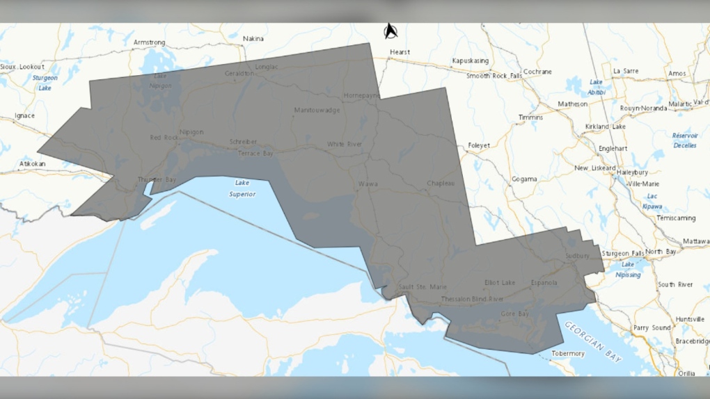 Weather alert map showing special weather statements (grey) in northeastern Ontario as of 5:15 p.m. on April 28, 2024. (Supplied/Environment Canada)
In statements on Sunday , weather forecasters said significant freezing rain or heavy rain is possible into Monday.
Freezing rain
As of 1 p.m., the special weather statement regarding freezing rain were in effect for the communities of Agawa, Beardmore, Black Sturgeon Lake, Caramat, Chapleau, Geraldton, Gull Bay, Hornepayne, Jellicoe, Lake Superior Park, Longlac, Macdiarmid, Manitouwadge, Marathon, Missinaibi Lake, Nipigon, Pukaskwa, Raith, Superior North, Superior West, Thunder Bay, Upsala, Wawa and White River.
“A low pressure system is expected to affect the region and a period of freezing rain and ice pellets is possible,” read the updated statement.
"For most areas freezing rain will be brief before changing to rain or snow, however areas of higher terrain may see freezing rain last slightly longer."
Hazards include ice build-up and icy surfaces due to freezing rain.
Forecasters said that power outages are possible during the weather event and the freezing rain may result in surfaces such as highways, roads, walkways and parking lots becoming slippery.
 An undated file photo of ice formed from freezing rain. (CTV News)
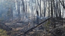
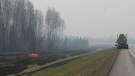
Heavy rain
As of shortly before 1:30 p.m., special weather statements were issued in the communities of Greater Sudbury and area, Manitoulin Island Sault Ste. Marie, Batchawana Bay, Blind River, Elliot Lake, Killarney, Montreal River Harbour, Ranger Lake, Searchmont and St. Joseph Island for heavy rainfall with 20 – 30mm of rain expected from Sunday evening into Monday afternoon or evening.
“A low pressure system will bring another round of rain to the area,”read the statements.
“The ground, already near saturation, has little ability to absorb further rainfall.”
Forecasters said localized flooding in low-lying areas is possible.
 Several communities in northeastern Ontario are under weather alerts for heavy rain. (File photo/CTV News)
To report severe weather, send an email to ONstorm@ec.gc.ca or tweet reports using #ONStorm.
Original story:
Environment Canada issued a severe thunderstorm watch for several communities in northeastern Ontario on Saturday afternoon – primarily the Greater Sudbury area and West Nipissing.
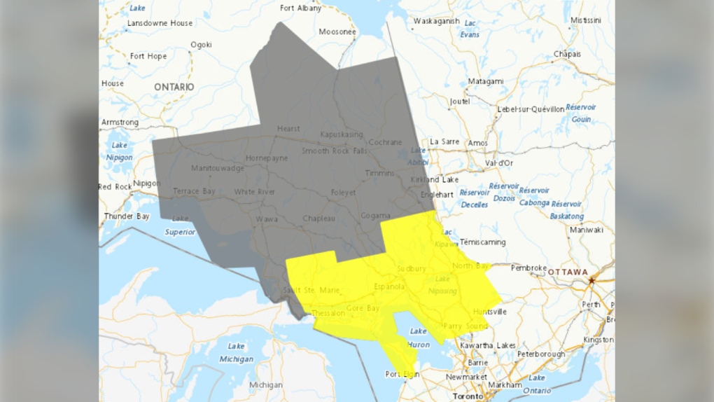 Weather alert map (yellow -- thunderstorm watch and grey -- rainfall weather statement) as of 4:15 p.m. on April 27, 2024. (Supplied/Environment Canada)
The watch includes areas of North Bay, Parry Sound, West Nipissing and Greater Sudbury and vicinity along with the communities of Bayfield Inlet, Blind River, Bruce Peninsula, Burk's Falls, Chapleau, Dunchurch, Elliot Lake, Espanola, French River, Killarney, Manitoulin Island, Mattawa, Missinaibi Lake, Muskoka, North Bay, Powassan, Ranger Lake, Sauble Beach, South River, Temagami, Temiskaming Shores, Thessalon and Tobermory.
This comes as most of the region was already under a special weather statement for rainfall of up to 45mm and flood watches are in effect for most areas affected.
“Conditions are favourable for the development of severe thunderstorms that may be capable of producing large hail and heavy rain,” Environment Canada said in its statements.
Hazards include rapid rainfall of up to 50mm in an hour, twoonie size hail, and flash flooding late Saturday afternoon into the night.
“Large hail can damage property and cause injury,” the statement said.
“Heavy downpours can cause flash floods and water pooling on roads.”
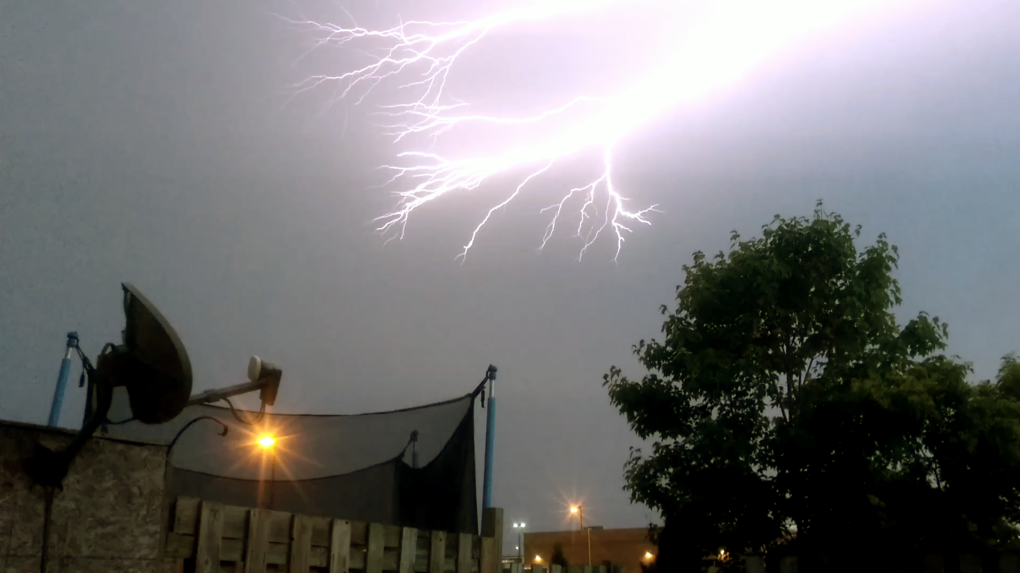 Lightning strikes a North Bay, Ont., sky on June 11, 2017. (File photo/Supplied/Cody Holliday)
Severe thunderstorm watches are issued when atmospheric conditions are favourable for the development of thunderstorms.
“(Storms) could produce one or more of the following: large hail, damaging winds, torrential rainfall,” read the statement.
Emergency Management Ontario recommends that you take cover immediately if threatening weather approaches, said Environment Canada officials.
For more information on how to prepare for an emergency, visit their website.
To report severe weather, send an email to ONstorm@ec.gc.ca or tweet reports using #ONStorm.


CTVNews.ca Top Stories

This type of screen time has the worst effect on kids: experts
According to some experts, there is one type of screen time that is continuously excessive, and it's having a severe effect on our children.
Grayson Murray's parents say the two-time PGA Tour winner died of suicide
Grayson Murray's parents said Sunday their 30-year-old son took his own life, just one day after he withdrew from a PGA Tour event.
Blaine Higgs 'furious' over sexual education presentation
New Brunswick Premier Blaine Higgs has shared his anger on social media over a presentation in at least four high schools.
Some birds may use 'mental time travel,' study finds
Real quick — what did you have for lunch yesterday? Were you with anyone? Where were you? Can you picture the scene? The ability to remember things that happened to you in the past, especially to go back and recall little incidental details, is a hallmark of what psychologists call episodic memory — and new research indicates that it’s an ability humans may share with birds called Eurasian jays.
Trump confronts repeated boos during raucous Libertarian convention speech
Donald Trump was booed repeatedly while addressing Saturday night’s Libertarian Party National Convention.
Driver, 18, gets $3,000 ticket, 32 demerit points after speeding on Laval boulevard
A young driver received a hefty fine from Laval police after they say he was driving nearly 100 km/h over the posted speed limit.
Indianapolis 500 delayed as strong storm forces fans to evacuate Indianapolis Motor Speedway
The start of the Indianapolis 500 was delayed as a strong storm pushed through the area Sunday, forcing Indianapolis Motor Speedway officials to evacuate about 125,000 fans who had already arrived for "The Greatest Spectacle in Racing."
Hamas rocket attack from Gaza sets off air raid sirens in Tel Aviv for the first time in months
Hamas fired a barrage of rockets from Gaza that set off air raid sirens as far away as Tel Aviv for the first time in months on Sunday in a show of resilience more than seven months into Israel's massive air, sea and ground offensive.
At least 13 dead in Texas, Oklahoma and Arkansas after severe weather roars across region
Powerful storms killed at least 13 people and left a wide trail of destruction Sunday across Texas, Oklahoma and Arkansas after obliterating homes and destroying a truck stop where dozens sought shelter in a restroom during the latest deadly weather to strike the central U.S.
Shopping Trends
The Shopping Trends team is independent of the journalists at CTV News. We may earn a commission when you use our links to shop. Read about us.


Barrie
-
Multi-vehicle crash causes road closures in Orangeville
A multi-vehicle collision has resulted in road closures in Orangeville.
-
Simcoe County residents unite to support those with multiple sclerosis
On Sunday, residents from Simcoe County gathered in Barrie to show their support for those with multiple sclerosis.
-
Coldwater Lions Club annual duck race returns
The annual Coldwater Duck Race, hosted by the Coldwater Lions Club, took place on Saturday.
Toronto
-

'Bigger than just music:' Canadians remember Punjabi rapper two years after killing
Shub Karman was out for a recent walk in Calgary, when he passed a car full of kids singing along to the music of his favourite Punjabi rapper.
-
Female driver dead after vehicle crashes into Oshawa home
A woman is dead after a vehicle crashed into a house in Oshawa early Sunday morning.
-
'Language is identity': Indigenous Ontario legislator to make history at Queen's Park
Decades after being punished in a residential school for speaking his own language, Sol Mamakwa will hold the powerful to account at Ontario's legislature in the very same language past governments tried to bury.
Ottawa
-

Here are the winners of the Ottawa marathon and half-marathon
Ethiopian runners Tesfaye Anbesa and Maregu Hayelom are the winners of the Tartan Ottawa International Marathon on Sunday.
-
Man seriously injured following an 'assault' on Downpatrick Road
The Ottawa Police Service says a 30-year-od man was seriously injured Sunday morning following what police call "an assault" on Downpatrick Road, in Ottawa's south-end.
-
Should you buy new or resale house? Here's what you need to know
There are many decisions to make before deciding to buy a house and one of those is whether to buy a new or a resale one.
Kitchener
-

Most-read stories of the week: Truck driver heroes, Kitchener strip club misconduct, population growth
Two Purolator truck drivers being hailed as heroes, misconduct in a Kitchener strip club, and population growth for the Region of Waterloo round out the most-read stories of the week.
-
KW Titans lose to London in Basketball Super League finals
Much like the Kitchener Rangers, the KW Titans season has ended at the hands of a team from London.
-
Disturbance in Waterloo involving racial slurs under investigation
Regional police are investigating a disturbance in Waterloo that involved racial slurs.
London
-

Huron County fire crews tackle blaze at Goderich, Ont. Home Hardware
Huron County fire crews spent Saturday evening extinguishing a fire at hardware store in Goderich.
-
More than 100 people lace up for cystic fibrosis walk in London, Ont.
At just 12 years old, Kaylee Chappell already knows what it’s like to live with a debilitating disease. You wouldn’t know it from looking at her, but Kaylee has been dealing with cystic fibrosis for most of her life.
-
Hundreds lace up for London MS Walk at Springbank Park
More than 200 people took part in London’s MS Walk at Springbank Park Sunday, one of more than 50 walks in cities across Canada.
Windsor
-

Search underway for missing swimmer on Lake St. Clair
A search is currently underway for a Michigan man who police said jumped into the waters of Lake St. Clair on Saturday afternoon and did not resurface.
-
Suspect sought after teen boy repeatedly stabbed
Windsor police are searching for a suspect after a 16-year-old boy was stabbed multiple times following a verbal dispute on Saturday night.
-
50 people involved in 'physical altercation,' multiple youths arrested
Multiple youths have been arrested and charged after police responded to a 'physical altercation' involving approximately 50 people in Chatham Saturday night.
Montreal
-

Concordia University researcher uses AI to identify counterfeit coins
A researcher at Montreal's Concordia University and her team have developed an innovative technique for accurately identifying counterfeit coins using artificial intelligence (AI).
-
About one Quebec child per day taken to ER for drowning, near-drowning: research
An average of one child a day goes to the emergency room for a drowning or near-drowning in Quebec during the summer months, new research has found.
-
Quebec Liberals tout their credibility on managing public finances
The Liberals' credibility is 'through the roof' when it comes to managing public finances, said PLQ interim leader Marc Tanguay on Sunday at his party's general convention in a Bromont hotel.
Winnipeg
-

Who is Buffalo Woman? Serial killer trial hears of police efforts to identify victim
In mid-March 2022, a young Indigenous woman stood outside Winnipeg's Salvation Army and spoke with a man who invited her back to his home.
-
Winnipeg firefighters tackle two fires overnight
Winnipeg firefighters battled two blazes Saturday night in Point Douglas and Daniel McIntyre.
-
‘It’s pretty alarming’: Urban wildlife encounters in Winnipeg this week
When you consider what kind of animals you might encounter in your Winnipeg neighborhood, a bear probably isn’t on your list.
Atlantic
-

Blaine Higgs 'furious' over sexual education presentation
New Brunswick Premier Blaine Higgs has shared his anger on social media over a presentation in at least four high schools.
-
57-year-old Carleton man dies following boating accident: P.E.I. RCMP
A 57-year-old man from Carleton, P.E.I., has died following a boating incident in the Summerside Harbour.
-
'Best office in the world': Unique business located in N.B. tourism corridor
Lorena DePrato-Najnar and her husband Paul Najnar are the owners of Fundy Coast Sea Soap and Sea Salt, which is located in a tourism corridor between Riverside-Albert, N.B., and Alma, N.B.
N.L.
-

Unknown Newfoundland soldier from the First World War heads back home from France after 100 years
Canadian soldiers and government officials arrived in northeastern France this week for a historic mission: returning an unknown Newfoundland soldier back home.
-
Newfoundland grandmothers can wail on the accordion. A historian wants them on stage
79-year-old Madonna Wilkinson has been playing the accordion since she was 15, when she picked one up that had been left behind at one of her parents' rollicking parties in the oceanside town about 25 kilometres north of St. John's, N.L. She has played Sunday masses and St. Patrick's Day parties, and community events of all kinds.
-
The latest advice for expecting parents? Sign up for child care as soon as you're pregnant
Canada's new $10-a-day child care program is expanding, but there's growing evidence that demand for the program is rising even faster, leaving many parents on the outside looking in.
Calgary
-

Calgary police looking for woman, 22, missing since Friday
Calgary police are seeking the public’s help in locating a woman who was reported missing from the northwest community of Sage Hill.
-
Road closures in effect for Calgary Marathon
Several roads are closed for the Calgary Marathon on Sunday morning.
-
Stampeders pounce on Lions for 30-6 pre-season win
An early heads-up play by Marken Michel was all the Calgary Stampeders needed to propel them to a 30-6 pre-season win over the B.C. Lions at McMahon Stadium on Saturday.
Edmonton
-

Protesters express anger at provincial government at 'Enough is Enough UCP' protest Saturday
Hundreds of protesters gathered at the Alberta legislature Saturday to express their discontent with Premier Danielle Smith and the UCP government.
-
Stars beat Oilers 3-1 to even Western Conference final 1-1
Mason Marchment scored the winner early in the third period as the Dallas Stars beat the Edmonton Oilers 3-1 on Saturday to even the NHL's Western Conference final 1-1.
-
Appeal denied for Edmonton soldier found guilty of trying to kill her 3 children
A former Canadian Armed Forces member has been denied an appeal after being found guilty of trying to kill her three children.
Regina
-

Lauther's late field goal lifts Roughriders over Elks 28-27 in pre-season action
Brett Lauther's 23-yard field goal with 23 seconds left lifted the Saskatchewan Roughriders to a 28-27 victory over the Edmonton Elks on Saturday in CFL pre-season action.
-
'Inspires a sense of adventure': Sask. man conquers Mount Everest
A Saskatchewan man made it to the summit of Mount Everest earlier this month.
-
Endangered little brown bats in prairies under study by university research teams
Research teams from the University of Regina and the University of Winnipeg are working to study migration patterns of the endangered little brown bat.
Saskatoon
-

Hundreds walk in Saskatoon to raise awareness for Alzheimer's
A walking party of 200 people gathered at River Landing Amphitheatre on Saturday to prepare for either a one or four-kilometer walk to advocate awareness for Alzheimer's, dementia, and other neuro-degenerative diseases.
-
'Inspires a sense of adventure': Sask. man conquers Mount Everest
A Saskatchewan man made it to the summit of Mount Everest earlier this month.
-
Sask. swimmer qualifies for 2024 Olympic Games, sets Canadian record
A swimmer from Saskatoon has qualified for the 2024 Olympic Summer Games in Paris.
Vancouver
-
‘Tremendous amount of fire’: Crews continue to face challenges in northeastern B.C.
The BC Wildfire Service provided an update Sunday on conditions in the northeastern part of the province, highlighting the challenges posed by ongoing drought and unstable weather.
-
Armed, masked men steal cell phone in Surrey
Mounties in Surrey are investigating after two armed, masked men stole a cell phone Friday.
-
'Making his legacy come alive': Ball hockey tournament honours fallen B.C. RCMP Const. Rick O’Brien
Dozens gathered at a rink in Maple Ridge, B.C., on Saturday to play in a ball hockey tournament in honour of fallen B.C. RCMP Const. Rick O’Brien.
Vancouver Island
-

Whitecaps offering free tickets to fans attending Saturday's Messi-less match
In the wake of major disappointment among soccer fans who were hoping to see Lionel Messi play at BC Place on Saturday, the Vancouver Whitecaps are offering what seems to be a consolation prize.
-
Fatal plane crash reported near Squamish, B.C.
The Transportation Safety Board of Canada has confirmed it is working with local Mounties and the BC Coroners Service after a plane crash near Squamish, B.C. Friday night.
-
No merger: BC Conservatives rejected non-competition deal, BC United says
BC Conservatives have rejected a non-competition deal proposed by BC United, the party formerly known as the BC Liberals says, putting an end to talks about a possible merge between the two parties.


