Spike in forest fires in the northeast in the last 24 hours
There have been a dozen new forest fires since its last report, Ontario Forest Fires said Thursday evening. That includes four late Wednesday evening and eight on Thursday.
The new fires from Wednesday are:
Chapleau 11, is a 0.4-hectare wildland fire that is being held. This fire is located about 11.5 kilometres northwest of Foleyet.
Hearst 13 is a 0.1-hectare wildland fire that is under control. This fire is located west of Sweet Lake, about 45 kilometres northeast of Hearst and 35 kilometres north of Highway 11.
Sudbury 28 is a 0.1-hectare wildland fire that is under control. This fire is located along the channel of Matagamasi Lake, approximately nine kilometres northeast of Wanapitei Lake.
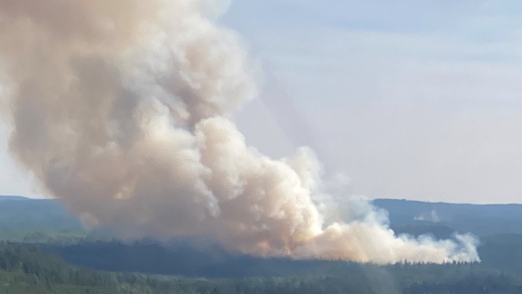 Photo taken by Frank Aquino, CL-415 pilot, on Aug. 21, as air support was arriving on initial dispatch on wildland fire Wawa 13. At the time of this update, Wawa 13 is 19 hectares and is not yet under control. (Frank Aquino/Ontario Forest Fires)
Hearst 14 was a 0.1-hectare wildland fire that is now out.
The eight new fires reported as of early Thursday evening are:
Timmins 15 is a 0.3-hectare wildland fire that is under control. This fire is located north of Hoodoo Lake, about 15 kilometres southeast of Foleyet.
Cochrane 36 is a 0.2-hectare wildland fire that is under control.
Timmins 16 is a five-hectare wildland fire that is not yet under control. This fire is located south of Bigwater Lake, about 10 kilometres north of Timmins and 0.2 kilometres west of Highway 655. This fire received joint response with the municipality in addition to aerial fire suppression support. An increase in fire activity Thursday afternoon is creating additional smoke, which may be seen from or impact visibility on the highway. For highway conditions, please refer to Ontario 511.
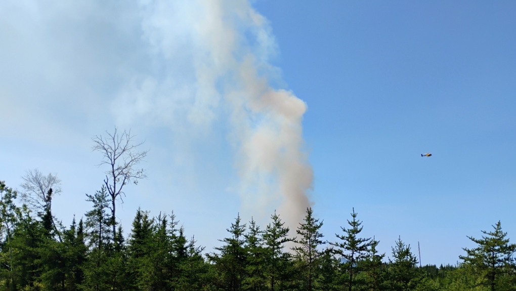 A photo of Timmins 16, taken Thursday just north of Timmins. (Photo courtesy of Jacques Nolet)
North Bay 13 was a 0.1-hectare wildland fire that is now out.
Sudbury 29 is a 0.1-hectare wildland fire that is being held. This fire is located about 5.5 kilometres from the intersection of Highways 69 and 637.
North Bay 14 is a 0.1-hectare wildland fire that is not yet under control. This fire is located on an island on Lake Temagami, about 28 kilometres west of Temagami.
Cochrane 37 is a one-hectare wildland fire that is not yet under control. This fire is located about 10.5 kilometres west of Highway 652, about 88 kilometres northeast of Cochrane.
Cochrane 38 is a one-hectare wildland fire that is not yet under control. This fire is located about 1.5 kilometres south of Nellie Lake, about one kilometre north of Jacobs Hill Road and 6.7 kilometres west of Iroquois Falls.
At the time of this update, there are 44 active wildland fires in the Northeast Region: eight are not under control, two are being held, 11 are under control and 23 are being observed.
- Download our app to get local alerts on your device
- Get the latest local updates right to your inbox
Fire of note is Kirkland Lake 5, located about five kilometres north of Stull Lake, five kilometres southeast of McKee Lake, and about 80 kilometres west of Latchford.
This fire is 889 hectares in size and is not under control at the time of this update. FireRanger crews and helicopters with bucketing capabilities continue to work on this fire. Updated fire perimeter can be consulted on the province’s interactive map.
The fire hazard is high for most of the Northeast Fire Region. There is an extreme fire hazard in the Far North, including Peawanuck. There is a moderate fire hazard along the Highway 651 corridor, around Kapuskasing, and for areas east of the Highway 11 corridor between Temagami and Gravenhurst.
There is a low fire hazard for the southeastern point of the Northeast Region.


CTVNews.ca Top Stories

2 dead, third in critical condition after attack in Kingston, Ont., suspect arrested
Two people are dead and a third suffered life-threatening injuries following an attack at an encampment in Kingston, Ont. Thursday. A suspect has been arrested following a multi-hour standoff.
B.C. will scrap carbon tax if feds remove requirement: Eby
British Columbia’s premier says the province will end the consumer carbon tax if the federal government removes the legal requirement to have one.
Trump rules out another debate against Harris as her campaign announces US$47M haul in hours afterward
Donald Trump on Thursday ruled out another presidential debate against Kamala Harris as her campaign announced a massive fundraising haul in the hours after the two candidates met on stage.
TIFF pauses screenings of documentary about Russian soldiers due to 'significant threats'
The Toronto Film Festival says it has been forced to pause the screenings of a documentary about Russian soldiers this weekend, citing 'significant threats to festival operations and public safety.'
'Keep your bags packed': Consul general grilled over $9M NYC condo purchase
After weeks of pressure, Canada's consul general Tom Clark is testifying on Thursday before a House of Commons committee about the purchase of his new official residence in New York that generated a lot of political attention over the summer.
Georgia judge dismisses two criminal counts against Trump, court filing shows
A Georgia judge on Thursday dismissed two criminal counts in the U.S. state's 2020 election interference case against Republican presidential candidate Donald Trump and one other count against allies of the former president.
Family of Sikh man speaks out against Toronto-area hospital after beard shaved
The family of a Sikh man from Brampton is seeking an apology, an explanation, and a promise to do better from the local hospital network after they say the facial hair of their loved one was removed without their consent.
This Italian lawyer says he thought he was buying a regular print of Churchill, not the 'mythical' stolen portrait
When Nicola Cassinelli, Italian lawyer and occasional art collector, bid on a portrait of the late U.K. prime minister Winston Churchill, he says, he didn't know it would land him in the centre of an international criminal investigation.
NEW
NEW N.B. premier’s asylum seeker comments spark controversy
Claims from New Brunswick Premier Blaine Higgs that Ottawa wants to force the province to take in 4,600 asylum seekers are "largely fictitious," says federal Immigration Minister Marc Miller.
Shopping Trends
The Shopping Trends team is independent of the journalists at CTV News. We may earn a commission when you use our links to shop. Read about us.


Barrie
-

Ont. police officer's spouse charged in historical sexual assault case involving a child
CTV News is learning more about disturbing allegations of sexual assault from 14 years ago in Beeton involving the husband of a Peel Regional police officer.
-
Guns & high capacity magazines seized, teens arrested after threats against Collingwood, Ont. school
Ontario Provincial Police (OPP) officers investigating a threat made against a Simcoe County school arrested two young men and seized several weapons.
-
House fire in Barrie displaces residents, cause under investigation
Emergency crews battled heavy smoke and flames after a fire broke out in a garage at a Barrie home Thursday afternoon.
Toronto
-

Chow says Toronto’s traffic congestion plan is working, acknowledges more could have been done sooner
Mayor Olivia Chow said Thursday that new data show Toronto’s congestion management plan is working to reduce gridlock, with recent travel times for drivers and transit riders showing improvement in some of the most congested parts of the downtown core.
-
TIFF pauses screenings of documentary about Russian soldiers due to 'significant threats'
The Toronto Film Festival says it has been forced to pause the screenings of a documentary about Russian soldiers this weekend, citing 'significant threats to festival operations and public safety.'
-
LifeLabs workers in GTA poised to strike if deal not reached by Saturday
LifeLabs workers in the Greater Toronto Area could soon walk off the job if a deal isn’t reached with their employer.
Ottawa
-
2 dead, third in critical condition after attack in Kingston, Ont., suspect arrested
Two people are dead and a third suffered life-threatening injuries following an attack at an encampment in Kingston, Ont. Thursday. A suspect has been arrested following a multi-hour standoff.
-
Ottawa resident who tested positive for mosquito-borne virus dies, public health says
An Ottawa resident who died of a viral encephalitis this summer tested positive for the mosquito-borne virus eastern equine encephalitis (EEEV), the first human case of the virus in Ottawa.
-
'Buy Local': PSAC changes shopping message amid backlash for asking workers to boycott downtown Ottawa businesses
A federal public service union is now encouraging its members to "buy local" and support neighbourhood businesses, one day after a social media post suggested federal workers boycott downtown businesses in an apparent retaliation for the return-to-office mandate.
Kitchener
-

Early apple harvest for farmers in Region of Waterloo
Apple trees are already being harvested at the Martin's Family Fruit Farm in Waterloo, Ont., at least one week ahead of their typical schedule.
-
Waterloo, Ont. man with stage 4 cancer qualifies for Boston Marathon
A Waterloo, Ont. man diagnosed with a rare and aggressive form of cancer continues to beat all odds.
-
More kids facing food insecurity than ever before, say experts
Local organizations say the number of kids experiencing food insecurity has risen in Waterloo Region.
London
-

TVDSB releases expenses for off-site retreat to Toronto
More details have been released on the expenses associated with TVDSB's off-site planning meeting in Toronto.
-
Pedestrian fighting for life in hospital after overnight crash near Western
A pedestrian is in hospital with life-threatening injuries after a violent two car crash near the Western University gates on Richmond Street north early Thursday morning.
-
Survivor winner training to become a doctor in London, Ont.
A Canadian winner of the reality series Survivor is spending part of her $1 million U.S. paycheck to train to become a doctor in London, Ont.
Windsor
-

Chatham-Kent moving forward with tiny transitional cabins as number of homeless encampments grows
$3.8 million in funding has been approved by Chatham-Kent Council to see 50 tiny transitional cabins built on Chatham's east side.
-
Crash between car and tractor trailer kills two people
Around 1 p.m. on Wednesday, OPP, fire and EMS responded to a crash between a tractor trailer and a passenger vehicle, at the intersection of Inwood Road and Courtright Line in Brooke-Alvinston.
-
Could a Windsor resident win the record Lotto Max jackpot? Here are the odds:
Some Windsor lotto players are likely hoping for a historic $75 million win this Friday.
Montreal
-

Quebec legislature adopts motion ensuring no eligibility certificates needed to receive health care in English
A motion declaring that Quebecers are not required to present certificates of eligibility to receive health care in English was unanimously adopted by the National Assembly on Thursday.
-
Parents outraged after homeless man allegedly spits on a 3-year-old near daycare
Some parents in the Hochelaga-Maisonneuve borough are worried after a homeless man allegedly attacked a 3-year-old child while he was on his way to daycare located next to a homeless shelter.
-
Quebec MNA Youri Chassin leaves the CAQ ship
In another blow for the Coalition Avenir Québec (CAQ), Saint-Jérôme MNA Youri Chassin is leaving the party just hours after publishing an open letter criticizing his own government.
Winnipeg
-

'Low property taxes, friendly neighbours': How some Manitoba communities are selling small-town living
Amid a struggle to attract new growth to rural Manitoba, some communities are finding creative ways to sell Manitobans on small-town living.
-
Three new options unveiled for new Manitoba health cards
Premier Wab Kinew posted on Instagram Thursday asking for opinions on three draft designs for the new health cards.
-
Man charged after multiple child sex dolls seized from home: Winnipeg police
A Winnipeg man has been charged with multiple offences after sex dolls designed to look like children were seized from his home.
Atlantic
-
 NEW
NEWNEW N.B. premier’s asylum seeker comments spark controversy
Claims from New Brunswick Premier Blaine Higgs that Ottawa wants to force the province to take in 4,600 asylum seekers are "largely fictitious," says federal Immigration Minister Marc Miller.
-
Driver, 15, dies after crashing into power pole, tree in Stellarton, N.S.
A 15-year-old has died after a single-vehicle collision in Stellarton, N.S., early Thursday morning.
-
Tidal power junk: N.S. village wants huge, abandoned moorings moved from fishing area
Residents of a small Nova Scotia community are worried about who will remove four concrete-filled boxcars sitting in their harbour after a tidal power firm collapsed.
N.L.
-

Newfoundland and Labrador monitoring rise in whooping cough cases: medical officer
Newfoundland and Labrador's chief medical officer is monitoring the rise of whooping cough infections across the province as cases of the highly contagious disease continue to grow across Canada.
-
Dispute over unrecognized Inuit group halts major conference for Canadian North
A 16-year-old biennial event aimed at fostering business in the country's eastern Arctic and northern regions has been cancelled indefinitely as a dispute unfolds between Inuit in Canada and a Labrador group claiming to share their heritage.
-
Cow cuddling: Why a Newfoundland farm is offering quality time with these 'gentle creatures'
Jim Lester’s farm hopped on the cow-cuddling trend in early August, and his time slots have been pretty well sold out ever since.
Calgary
-

Calgary airport, WestJet still recovering from August hailstorm
The devastating hail storm that struck Calgary on Aug. 5 remains a major setback for the city’s airport, nearly two months after the event.
-
Calgary pipeline repairs to be complete by this weekend
Calgary Mayor Jyoti Gondek says construction work has been going well and is expected to be wrapped up by this weekend, with restrictions being lifted by Sept. 22.
-
'The hardest thing is to find a diagnosis': Calgary woman speaks out about neurological condition
A Calgary woman is spreading the word about an often misdiagnosed ailment, because of her own struggles with the neurological condition.
Edmonton
-

Police investigating 'targeted' triple homicide in Lloydminster, Sask.
Police in Lloydminster have confirmed they are investigating a triple homicide in the border city.
-
Edmonton police seize more than $1.2M in street drugs after months-long investigation
The Edmonton Police Service says more than 66 kilograms of drugs have been seized in a large-scale drug investigation in central Edmonton that started in December.
-
Snacks, seating and super-fast charging: What to expect at Edmonton's new EV-only service station
Electric vehicle (EV) drivers in Edmonton now have a place to grab a snack and relax while they charge up.
Regina
-

'Can be a real struggle': Veterinary shortage in Sask. particularly felt by exotic pet owners
As Saskatchewan is facing a shortage of veterinarians, owners of exotic pets are in a particularly tricky situation if their animal needs care.
-
Councillor Lori Bresciani to make 'major announcement' on upcoming election
Councillor Lori Bresciani will make a major announcement regarding her involvement in Regina's upcoming municipal election.
-
Sask. Entertainment Expo postponed to 2025 due to health concerns
This year’s edition of the Saskatchewan Entertainment Expo has been postponed until 2025.
Saskatoon
-

Saskatoon police ask board to green light 31 new positions after infusion of provincial cash
The Saskatoon Police Service (SPS) is asking its board to green light 31 new full-time positions, after the province committed to permanently fund a host of new officers last week.
-
Saskatoon Tribal Council shelter will face cuts after new proposed shelter opens: province
The proposed downtown location for the city’s newest homeless shelter is drawing criticism from the chief of the Saskatoon Tribal Council (STC), which runs the city’s largest emergency shelter.
-
Saskatoon police investigating death following garage fire
Saskatoon Police Service (SPS) is investigating after a person was found dead following a fire early Thursday morning.
Vancouver
-

B.C. will scrap carbon tax if feds remove requirement: Eby
British Columbia’s premier says the province will end the consumer carbon tax if the federal government removes the legal requirement to have one.
-
Harbour Air suspends service between Vancouver, Sunshine Coast, Vancouver Island, citing low demand
Seaplane operator Harbour Air says it is cancelling one of its routes between Vancouver and Vancouver Island, and temporarily suspending some flights to the Sunshine Coast, due to decreasing ticket sales.
-
B.C. signs national pharmacare deal with Ottawa, promises to expand drug coverage
British Columbia has become the first province in Canada to sign a pharmacare agreement with the federal government that would help the province fund hormone replacement therapy and diabetes expenses.
Vancouver Island
-
B.C. will scrap carbon tax if feds remove requirement: Eby
British Columbia’s premier says the province will end the consumer carbon tax if the federal government removes the legal requirement to have one.
-
Harbour Air suspends service between Vancouver, Sunshine Coast, Vancouver Island, citing low demand
Seaplane operator Harbour Air says it is cancelling one of its routes between Vancouver and Vancouver Island, and temporarily suspending some flights to the Sunshine Coast, due to decreasing ticket sales.
-
Dry conditions mean increased wildfire risk in B.C. through the fall
An expert with the BC Wildfire Service says relentless drought conditions for much of British Columbia sets the stage for more fire activity this fall.


