No new fires reported in the northeast, northwest prepares for more potential starts
There 27 active wildfires in the Northeast Region and most of the area is no longer consider at severe risk for forest fires, according to Saturday's update from Aviation, Forest Fire and Emergency Services (AFFES).
Of these active fires, six are under control and 21 are being observed, the report said. No new fires were reported in the Northeast Region Saturday.
“The most southern section of the region from North Bay to Port Severn and east to Carleton Place has a low to moderate fire hazard value,” said emergency officials.
Cochrane 7 remains the largest and most significant fire in the region – however it has been under control for the past few days. Cochrane 7, confirmed on June 2, is located northeast of Lake Abitibi and has burned 37,742 hectares.
- Download the CTV News app now and get local alerts on your device
- Get local breaking news and updates sent to your email inbox
NORTHWEST REGION
There 40 active wildfires in the Northwest Region with wildland fire hazard mainly low to moderate across the western half of the region, and moderate to high across the eastern half of the region, according to the AFFES update.
Of these active fires, five are not under control, four are being held, two are under control and 29 fires are being observed.
In Ontario, a fire classified as ‘being observed’ is being monitored to allow the ecological benefits of wildland fire to take place as it would in the natural environment without human intervention, the Ministry of Natural Resources and Forestry explained in a recent tweet.
“Initial attack crews have called 4 fires out in the past 24 hours,” said emergency officials, in the update.
“There were four new fires confirmed in the Northwest Region by the late afternoon.”
Red Lake 50 and Red Lake 51 were both called out on Saturday after being confirmed.
Nipigon 57 and Nipigon 58 are located approximately 41.2 kilometres and 48.5 kilometres southeast of Beardmore respectively, near Wintering Lake. Nipigon 57 is currently being held and Nipigon 58 is not yet under control. Both fires measure 0.1 hectares.
Sioux Lookout 33 remains the largest and most significant fire in the region – it is still not under control. Sioux Lookout 33 is located on the western edge of Wabakimi Provincial Park and is 60,394 hectares in size.
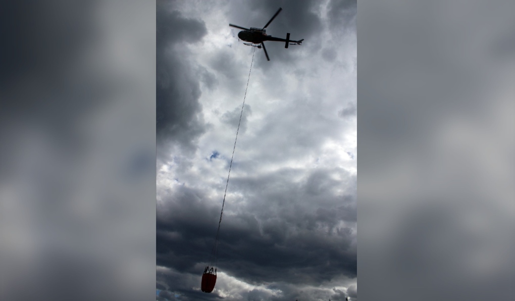 Helicopter bucketing operations are one form of aerial fire suppression used by Aviation, Forest Fire and Emergency Services to control active forest fires in Ontario. (Supplied)“Crews continue to establish hose lines while helicopter bucketing operations continue to work priority areas on the fire,” reads the report.
Sioux Lookout 44, located on the west side of Lake St. Joseph is now being held at 6,730 in size.
Nipigon 19 is located northwest of Ogoki Lake and Red Lake 28 is located 40 kilometers North of Lac Seul First Nation are still not under control and have grown to 10,182 and 19,177 hectares respectively – with crews continuing to establish hose lines working along side helicopter bucketing.
Emergency officials expect more fire starts in the region in the coming days.
Temperatures in many parts of the northwest are expected to climb to the 28-30°C range over the next week, according to Environment Canada forecasts.
FIRE BANS
The Restricted Fire Zone (RFZ) previously in place for the entire Fire Region of Ontario was lifted on July 11 and northeastern municipalities do not have fire bans currently in place.
 An undated photo of people roasting marshmallows over a campfire. (Image courtesy of Ontario Forest Fires/Twitter)“Lifting the RFZ does not mean we can let our guard down when it comes to preventing human-caused fires,” said emergency officials.
“We all need to remain vigilant and keep safety top of mind when having outdoor fires.”
THE 2023 FOREST FIRE SEASON
The 2023 forest fire season has been a busy one in Ontario, with a total of 450 confirmed fires reported so far this year, above the 10-year average of 412 fires for the same time period – and significantly more than the 148 total fires reported in 2022.
STAY UP-TO-DATE
CTVNewsNorthernOntario.ca will continue to monitor the ever-changing situation and will provide new information as it becomes available. Check back often for updates.
For a closer look at fire hazard conditions in your area, view the Ontario Forest Fire Info Map online here.
Shopping Trends
The Shopping Trends team is independent of the journalists at CTV News. We may earn a commission when you use our links to shop. Read about us.


CTVNews.ca Top Stories

Firefighters battle to control devastating Los Angeles wildfires as ferocious winds calm somewhat
A fast-moving fire broke out in the Hollywood Hills on Wednesday night, threatening one of Los Angeles' most iconic spots as firefighters battled to get under control three other major blazes that killed five people, put 130,000 people under evacuation orders and ravaged communities from the Pacific Coast to inland Pasadena.
Canada could impose tariffs on U.S. steel, orange juice in response to Trump threat
Canadian officials are narrowing a list of American products to target in the event the federal government must respond to U.S. tariffs on Canadian goods, CTV News has confirmed.
Can the U.S. really make Canada the 51st state?
Talk of Canada becoming the 51st American state has raised an existential question on this side of the border: Could it be done? Could the maple leaf make way to the stars and stripes? According to several experts, it may be possible, but not painless.
'True when I said it, true today': former Canadian PM Harper pushes back against Trump on social media
Former prime minister Stephen Harper doesn’t find U.S. president-elect Donald Trump’s jibes about Canada becoming the 51st U.S. state very amusing.
Convicted Jan. 6 rioter arrested as fugitive in Whistler, B.C.
An American citizen convicted of participating in the Jan. 6, 2021, riot on Capitol Hill who said he was seeking asylum in Canada has been arrested as a "fugitive from U.S. justice," according to authorities.
NEW
NEW Tipping guide to Canada: When, where and how much to tip for restaurants, taxis and more
CTVNews.ca has created an entirely unofficial guide to tipping in Canada to help visitors, newcomers and curious Canadians navigate the shifting social norms of when, where and how much to tip.
'On the front line': Quebec planes and B.C. helicopters battle L.A. wildfires
Water-bombing pilots and crews from Quebec and a British Columbia company have been grappling with high winds and heavy turbulence in the battle against massive Los Angeles wildfires, as Canadians with homes in the area are forced to flee fast-moving flames.
Canadians want Ottawa and provinces to team up against Trump tariff threats: Nanos survey
A majority of Canadians want Ottawa and the provinces to team up against U.S. tariff threats, according to a new survey by Nanos Research.
Attack on Chad's presidential palace leaves 19 dead
An attack on Chad's presidential palace left 18 assailants dead and six in custody, with one soldier killed and three wounded, state media reported Thursday.
Barrie
-

Over $65,000 in stolen goods seized during Alliston raid: OPP
Ontario Provincial Police executed a search warrant at a Boyne Street property in New Tecumseth, uncovering over $65,000 worth of allegedly stolen items, including a Kubota diesel side-by-side and various tools, dirt bikes, and equipment.
-
Alleged serial ticket scammer 'Todd the Fraud' seeks resolution in case
A Collingwood man nicknamed ‘Todd The Fraud’ by people who say they were defrauded by him in the sale of fake music concert and VIP NHL All-Star Game tickets in Toronto could soon be resolving his Barrie case.
-
Join in the evolution of transit in Innisfil
The Transit Master Plan and feedback from the community are on the schedules at three open houses in Innisfil.
Toronto
-

Canadians want Ottawa and provinces to team up against Trump tariff threats: Nanos survey
A majority of Canadians want Ottawa and the provinces to team up against U.S. tariff threats, according to a new survey by Nanos Research.
-
Ontario Premier Doug Ford says he is 'OK' after OPP vehicle he was in was 'sideswiped' in Highway 401 collision
Ontario Premier Doug Ford was uninjured after an OPP vehicle he was travelling in was involved in a collision on Highway 401 earlier today.
-
Toronto police arrest one of Canada's most wanted fugitives
One of Canada’s most wanted fugitives, who is the suspect in a fatal double shooting in south Etobicoke more than two years ago, has been arrested.
Ottawa
-

Canada as the 51st State: Americans in Watertown, N.Y. react
Watertown, N.Y. is a border city where opinions on Canada potentially becoming the 51st U.S. state are as diverse as the people themselves. New Yorkers living in the city about an hour south of the border are weighing in on the idea, with many sharing mixed emotions.
-
Elgin Street restaurant closes after 18 years in Ottawa's Centretown neighbourhood
St. Louis Bar and Grill has its doors on Elgin Street in Ottawa's Centretown neighbourhood, after serving customers for 18 years.
-
Cold stretch of weather to continue through the weekend in Ottawa
The stretch of cold weather continues to grip Ottawa, with the double-digit low temperatures expected to continue through the weekend.
Kitchener
-

Canada could impose tariffs on U.S. steel, orange juice in response to Trump threat
Canadian officials are narrowing a list of American products to target in the event the federal government must respond to U.S. tariffs on Canadian goods, CTV News has confirmed.
-
City council to discuss next steps to finalize redevelopment of former Stratford factory
After sitting empty for 50 years, the City of Stratford is moving closer to redeveloping the former location of the Grand Trunk Railways shop.
-
Pedestrian dies after crash involving Guelph city bus
A pedestrian has died after a crash involving a city bus in Guelph.
London
-

Bitter cold temperatures, chance of light flurries
Thursday morning is seeing bitter cold temperatures and a chance for light flurries throughout the day for the London region, according to CTV London Meteorologist Julie Atchison.
-
Career change: Dorchester, Ont. chiropractor signs professional soccer contract
Chiropractor Julia Benati is taking a leave from her clinic to pursue a professional contract after signing with the Ottawa Rapid FC franchise in the new Northern Super League (NSL).
-
Public input begins on the future of London's transportation network
Londoners are getting their say in how we’re all going to get around the city over the next 25 years.
Windsor
-

OPP Commissioner explains 'significant role' in new border measures
The Commissioner of the Ontario Provincial Police believes they can play a significant role in border security but said more resources will be needed for long-term sustainability.
-
Would updated MPAC assessments lead to skyrocketing property tax hikes?
Some residents may assume that a sharp rise in property values would lead to an equivalent increase in property taxes, but that's not the case. Here’s how it works.
-
Ontario Premier Doug Ford says he is 'OK' after OPP vehicle he was in was 'sideswiped' in Highway 401 collision
Ontario Premier Doug Ford was uninjured after an OPP vehicle he was travelling in was involved in a collision on Highway 401 earlier today.
Montreal
-

Two Quebec planes and their crews helping fight devastating L.A. wildfires
A pair of Quebec water bombers and their crews are in California helping fight the massive wildfires tearing through the Los Angeles area
-
Montreal Victoire edge Toronto Sceptres 4-2 in first PWHL game in Vancouver
Marie-Philip Poulin scored twice as her Montreal Victoire downed the Toronto Sceptres 4-2 in the first Professional Women's Hockey League game in Vancouver.
-
Man dies after conflict degenerates in Longueuil
A man in his 50s is dead after a conflict degenerated into an assault in Longueuil on Montreal's South Shore.
Winnipeg
-

Winnipeg hospital death to be investigated as critical incident
The recent death of a man waiting for care in a Winnipeg hospital’s emergency department is being investigated as a critical incident.
-
Protesters block heavy equipment from entering Lemay Forest; trees still being cut down
It's full-blown Lemayhem in St. Norbert. On Wednesday morning, protesters blocked the road to Lemay Forest in an effort to stop more tree cutting in the area.
-
Police chief’s remains believed to be found in fire aftermath
The remains of Manitoba First Nation Police Service’s (MFNPS) leader are believed to have been found following a fire at his home.
Atlantic
-

Police arrest suspect in two N.S. homicides
Police have arrested a New Brunswick man wanted for the deaths of two people in Nova Scotia last month.
-
Daughter of N.S. woman killed in Edmonton speaks out
Abigail Robson is mourning the death of her mother Ashley Burke, who was killed in Edmonton, Alta, in an act of intimate partner violence.
-
Crews working to fix broken water main in Dartmouth
Crews continue to work on a broken water main in the Burnside area of Dartmouth, N.S., Thursday morning.
N.L.
-

Adviser says Quebec-N.L. energy deal is 'very good,' as Opposition vows not to vote
Newfoundland and Labrador's Opposition Progressive Conservatives vowed Wednesday that they will not vote on a draft energy deal with Quebec's hydro utility until it is scrutinized by independent experts.
-
Newfoundland and Labrador energy deal with Quebec under scrutiny as debate opens
Newfoundland and Labrador politicians are digging into the details of the province's draft energy deal with Quebec as four days of debate begin today in St. John's, N.L.
-
Part of street washed away and state of emergency declared in N.L. town after storm
Damaging winds and pounding surf that washed away part of a street in a small northeastern town in Newfoundland on Sunday triggered a state of emergency in the coastal community.
Calgary
-

What could 'economic force' to merge countries look like for Canadian businesses?
Economists, business leaders and politicians are reacting to U.S. president-elect Donald Trump's comments that he'd use 'economic force' to acquire Canada as the 51st state.
-
'True when I said it, true today': former Canadian PM Harper pushes back against Trump on social media
Former prime minister Stephen Harper doesn’t find U.S. president-elect Donald Trump’s jibes about Canada becoming the 51st U.S. state very amusing.
-
'Extremely triggering': Facebook drug ads cause concern for Calgarian in recovery
A Calgary man who struggled with addiction for more than two decades is questioning why his Facebook account has been showing advertisements for drugs.
Edmonton
-

'This isn't just my mom's story,' says daughter of woman allegedly killed by partner
Abigail Robson says she moved from Nova Scotia to Alberta as a young girl with her mother 10 years ago for a fresh start.
-
ATA warns standardized testing will cause 'stress and anxiety' for kindergarteners
Kindergarteners in the province will receive standardized testing for the first time this month, something the Alberta Teachers’ Association (ATA) says will negatively impact both teachers and students.
-
'It's not substantial': ER doctor says new health-care leadership does nothing to solve current crisis in acute care
Alberta has named two temporary chief executive officers in the shifting acute health-care system, a move one Edmonton emergency medicine specialist says does little to address the current crisis in front-line medicine.
Regina
-

Saskatchewan RCMP head reflects on the complex challenges, successes of 2024
From the scourge of the addictions crisis to managing recruitment and enforcement in rural areas, the Saskatchewan RCMP had a busy 2024.
-
Regina murder suspect who appeared on national most wanted list arrested
The Regina Police Service (RPS) has arrested a suspect that appeared on Canada's Top 25 Most Wanted list – in relation to a homicide that occurred in May of 2024.
-
Saskatchewan town sees flurry of construction with $30K housing cheque program
An official with a town in southeastern Saskatchewan says its plan to offer $30,000 cheques to anyone building homes in the community is paying off.
Saskatoon
-

'You're killing them inside': Sask. hockey referee blows the whistle on verbal abuse of young officials
A Saskatchewan hockey referee is gaining widespread attention after posting a video on social media telling coaches and parents to “do better.”
-
Sask. man missing since Christmas found dead
A 50-year-old man from Prince Albert, reported missing on Christmas Eve, was found dead Wednesday.
-
Saskatoon residents oppose cell tower precedent
SaskTel is proposing a new cell tower placed on the corner of a Saskatoon park to improve coverage and network capacity, but nearby residents say it’s too close to their homes, and against City of Saskatoon policy.
Vancouver
-

Fewer paramedics on shift as BC Ambulance millions over budget
BC Emergency Health Services is cracking down on overtime in a cost-cutting measure, leaving more ambulances than usual unstaffed as front-line workers fear patients will face even longer delays.
-
B.C. Conservative leader alleges voting irregularities in critical Surrey-Guildford riding
John Rustad, the leader of the B.C. Conservative Party, says his party has uncovered what he calls voting irregularities in the critical Surrey-Guildford riding – where the margin of victory was just 22, and which gave the provincial New Democratic Party its majority.
-
Convicted Jan. 6 rioter arrested as fugitive in Whistler, B.C.
An American citizen convicted of participating in the Jan. 6, 2021, riot on Capitol Hill who said he was seeking asylum in Canada has been arrested as a "fugitive from U.S. justice," according to authorities.
Vancouver Island
-
Fewer paramedics on shift as BC Ambulance millions over budget
BC Emergency Health Services is cracking down on overtime in a cost-cutting measure, leaving more ambulances than usual unstaffed as front-line workers fear patients will face even longer delays.
-
B.C. Conservative leader alleges voting irregularities in critical Surrey-Guildford riding
John Rustad, the leader of the B.C. Conservative Party, says his party has uncovered what he calls voting irregularities in the critical Surrey-Guildford riding – where the margin of victory was just 22, and which gave the provincial New Democratic Party its majority.
-
Convicted Jan. 6 rioter arrested as fugitive in Whistler, B.C.
An American citizen convicted of participating in the Jan. 6, 2021, riot on Capitol Hill who said he was seeking asylum in Canada has been arrested as a "fugitive from U.S. justice," according to authorities.


