Friday, May 10, 2019 15:00 hrs
The Ministry of Natural Resources and Forestry – North Bay District is advising area residents that an Updated Flood Warning is in effect in the District until Friday, May 17, 2019.
This Updated Flood Warning replaces all Flood Warnings previously issued by the North Bay District.
The Ministry is closely monitoring the weather and developing watershed conditions. Further updates will be issued as appropriate.
TECHNICAL INFORMATION
Description of Weather System
Forecasts for the North Bay District area expect to see lessened precipitation over the next five days with accumulations ranging from 5-10 mm, with the majority of rainfall occurring in the southern portion of the district. Daytime highs for the same period are expected to range from 11-18 degrees Celsius, with nighttime lows ranging from 0-8 degrees Celsius.
Description of Current Conditions
The North Bay District has experienced significant increases in water levels and stream flows over the past two weeks. The combination of repeated rainfall and snowmelt has resulted in water levels across the district rising significantly, reaching or exceeding flood levels in many areas. Water levels are expected to continue to increase over the next five days. In some locations the ground is saturated or remains partially frozen and as a result has little ability to absorb further precipitation. In addition, some locations continue to experience snow melt which will continue to increase water levels and flow.
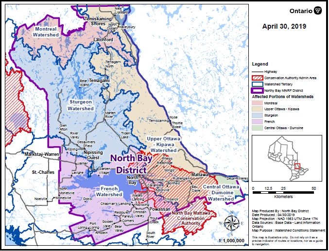
The Ottawa River Watershed continues to be affected by recent rainfall combined with snow melt on the watershed. Lake Temiskaming water levels are currently sitting at 179.70 m and are expected to rise by approximately 0.5 m (50 cm) to reach 180.20 m over the next five days. Water released from Lake Temiskaming flows down the Ottawa River to the Otto Holden Dam, in the Mattawa area, where higher than normal water levels will continue to increase and could exceed 155.7 m over the next several days.
The Montreal River Watershed area continues to see higher than normal water levels and flows which have reached or exceeded flood levels in many areas. Water levels in the watershed are expected to increase over the next five days. In the Latchford area, Bay Lake water levels have exceeded the maximum lake level of 277.15 m and are currently sitting at 277.23 m. Bay Lake levels are forecast to continue to rise significantly in the next few days even with the maximum discharge possible from the Latchford dam.
Lake Temagami continues to see a rise in water levels and could rise by over 20 cm over the next four days due to increased pressures on the watershed.
The Sturgeon River, Lake Nipissing and French River areas have recently been impacted by significant rainfall, stormwater runoff and strong winds causing much higher than normal water levels. Lake Nipissing water levels are currently sitting at 196.40 m, well above the Maximum ‘Non-Damage’ water level of 196.22 m. Water levels are forecast to climb at a rate of 2 cm per day and could reach or exceed 196.59 m by next week. Residents along the French River will begin to see a rise in water levels over the next week as a result of higher than normal local inflows and increased discharge from Lake Nipissing.
Municipalities and residents, especially those in low-lying areas and along shorelines, are encouraged to monitor these conditions and prepare accordingly. Shorelines and banks adjacent to rivers and creeks are very slippery and unstable at this time and, when combined with cold open water, pose a serious hazard.
Road closures and sand bagging efforts continue across much of the North Bay District and many area residents have been impacted by localized flooding.
A close watch on local forecasts and conditions is recommended.
DEFINITIONS
WATERSHED CONDITIONS STATEMENT – FLOOD OUTLOOK: gives early notice of the potential for flooding based on weather forecasts calling for heavy rain, snow melt, high winds or other conditions
WATERSHED CONDITIONS STATEMENT – WATER SAFETY: indicates that high flows, melting ice or other factors could be dangerous for such users as boaters, anglers and swimmers but flooding is not expected.
FLOOD WATCH: potential for flooding exists within specific watercourses and municipalities
FLOOD WARNING: flooding is imminent or occurring within specific watercourses and municipalities.
LEARN MORE
- Surface Water Monitoring Centre public webpage www.ontario.ca/flooding
- Environment Canada bulletins: www. weather.gc.ca
- A close watch on local conditions and weather forecasts from Environment Canada is recommended.


