As March ends, winter storm watch begins in northern Ont.
Several communities in northern Ontario are currently under a winter storm watch, with as much as 40 cm of snow expected between now and Saturday night.
Affected areas include areas around Sudbury, North Bay, Sault Ste. Marie, Blind River Elliot Lake and Temagami,
“Some snow Friday, then a winter storm Friday night into Saturday,” Environment Canada said Thursday evening.
Snowfall accumulations of 5 to 10 cm are expected Friday, with snow and ice pellet accumulations of 20 to 30 cm expected Friday night into Saturday.
Expect reduced visibility due to heavy snow and blowing snow, as well as freezing rain with ice accretion of 2 to 3 mm possible and strong wind gusts up to 60 km/h.
“Two weather systems will affect the area over the next two days,” Environment Canada said.
“There will then be a brief break in the precipitation Friday evening before a second and much stronger system moves in overnight Friday. Depending on the track of the system, some areas will see heavy snowfall while others will receive significant ice accretion.”
Strong winds are also expected, and combined with any ice accretion could produce utility outages.
“There remains some uncertainty at this point to the placement of the heaviest snow and freezing rain,” the warning said.
“Warnings may be issued as the event draws nearer.”


CTVNews.ca Top Stories

Which Canadian cities have the highest and lowest grocery prices?
Where you live plays a big factor in what you pay at the grocery store. And while it's no secret the same item may have a different price depending on the store, city or province, we wanted to see just how big the differences are, and why.
'State or state-sponsored actor' believed to be behind B.C. government hacks
The head of British Columbia’s civil service has revealed that a “state or state-sponsored actor” is behind multiple cyber-security incidents against provincial government networks.
Swarm of 20,000 bees gather around woman’s car west of Toronto
A swarm of roughly 20,000 bees gathered around a woman’s car in the parking lot of Burlington Centre.
Mother assaulted by stranger while breastfeeding baby in her car: Vancouver police
A person was arrested in East Vancouver Thursday after allegedly entering a car while a mother was breastfeeding her four-month-old boy.
More than half the Canadians once detained in Syrian camps for suspected ISIS family members have returned home
A total of 29 Canadians have been freed from detention camps in northeast Syria and brought back to Canada since human rights advocates began lobbying for their release years ago.
Rare severe solar storm Friday could bring spectacular aurora light show across Canada
A rare and severe solar storm is expected to bring spectacular displays of the northern lights, also known as aurora borealis, across much of Canada and parts of the United States on Friday night.
Canada abstains from Palestinian UN membership vote but supports two-state solution
Canada was one of 25 countries that abstained from a United Nations vote on Palestinian membership that passed with overwhelming support on Friday.
Amish youth experience a rite of passage called Rumspringa. It’s not what you might think
The idea of “Rumspringa” has a specific spot in the American imagination. A rite of passage for young people in some Amish communities, Rumspringa is seen by most outsiders as a wild time away from strict Amish rules, when teenagers can experiment with the modern vices of the world.
Djokovic needs medical attention after getting knocked on the head by a water bottle at Italian Open
Novak Djokovic needed medical attention after apparently getting knocked on the head by a water bottle after a win at the Italian Open on Friday.
Shopping Trends
The Shopping Trends team is independent of the journalists at CTV News. We may earn a commission when you use our links to shop. Read about us.


Barrie
-
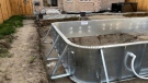
Barrie men charged with fraud in OPP investigation into pool installation scam
Two Barrie men have been charged with fraud in connection with a lengthy OPP investigation after several customers seeking pool installations were allegedly scammed out of thousands of dollars.
-
OPP probes $50,000 damage to Hydro One infrastructure in Muskoka
Provincial police are investigating after extensive damage was done to Hydro One equipment in Muskoka.
-
Here's why your yard waste may have been sitting at the curb for days
A recent change in curbside collection has left some green-thumbed enthusiasts scratching their heads as bags of yard waste linger by the curb, awaiting pickup.
Toronto
-

Swarm of 20,000 bees gather around woman’s car west of Toronto
A swarm of roughly 20,000 bees gathered around a woman’s car in the parking lot of Burlington Centre.
-
'Just wait': Toronto mayor hints that WNBA team is coming to the city amid multiple reports
Toronto Mayor Olivia Chow says that she is hopeful an announcement could be made soon amid multiple reports that a WNBA team is coming to Toronto in 2026.
-
What to know about road and transit closures in Toronto this weekend, May 11-12
Here are the road closures in Toronto this weekend to keep in mind.
Ottawa
-

Ottawa man charged in connection to fatal shooting at Manor Park home
A 20-year-old man is facing a charge of second-degree murder in connection to a fatal shooting during a poker game in Ottawa's Manor Park neighbourhood.
-
'The whole community is devastated': Sharbot Lake, Ont. mourning the death of teen in crash
A high school student at Granite Ridge Education Centre in Sharbot Lake, Ont. died in a single-vehicle crash on Thursday. Five other students were injured in the crash.
-
Ottawa's 3-container limit for curbside garbage takes effect this fall
The City of Ottawa's new three-garbage item limit for household waste will take effect on Sept. 30, with a three-month phase-in period for the limit. As of December, collection staff will only collect three garbage items from households every two weeks.
Kitchener
-

9-year-old prodigy pianist to perform with former K-W Symphony musicians
A young prodigy pianist is set to perform alongside former members of the Kitchener-Waterloo Symphony, as part of a benefit concert.
-
What you should keep in your emergency supply kit
Could you survive for 72 hours following a natural disaster? The Region of Waterloo is hoping that question sparks a conversation around emergency preparedness.
-
Ontario coroner to investigate death of man who suffered cardiac arrest while waiting in ER
A provincial coroner will be investigating the death of 68-year-old David Lippert, who suffered a cardiac arrest while waiting in a crowded emergency room in Kitchener, Ont.
London
-

Suspicious fire being investigated in London
A suspicious fire in London is under investigation by police and fire officials. According to London fire, crews knocked down the scene in an “offensive strategy.”
-
London Majors debut new look for 100th season
The London Majors is debuting a new look ahead of the 2024 season. Fans can expect changes ton the brand and on-field look as well as two new logos to celebrate the 100th season of the majors.
-
'The need is immeasurable': St. Thomas Elgin Food Bank usage doubles
Officials at the St. Thomas Elgin Food Bank report a 50 per cent jump in usage over the past three years.
Windsor
-

Windsor’s unemployment rate jumps back into highest in Canada
The unemployment rate in Windsor increased dramatically last month and is the highest in Canada, according to Statistics Canada.
-
City of Windsor has unanswered questions as feds, province spar over housing funding
A dispute between the federal and provincial governments over the National Housing Strategy nearly put the City of Windsor $7 million in the hole and questions still remain over when and how much funding the city will receive.
-
Highway 401 ramps at Queens Line closed after crash
OPP are informing the public of a crash on the Highway 401 ramps at Queens Line in Chatham-Kent.
Montreal
-
 BREAKING
BREAKING McGill University seeks emergency injunction to remove pro-Palestinian encampment from campus
McGill University has filed a request for an injunction to have the pro-Palestinian encampment removed from its campus.
-
Man charged after truck strikes and kills driver changing flat tire on side of Montreal-area highway
A 43-year-old man has been charged after a driver was struck and killed while changing a tire on the side of a Highway 15 near Montreal on Thursday.
-
This iconic Canadian song is turning 50
Andy Kim's 'Rock Me Gently' is marking a major milestone, as it celebrates its 50th anniversary.
Winnipeg
-

'Devastating': Businesses concerned over watercraft ban on Clear Lake
Businesses in the Clear Lake area are concerned about the future following a temporary ban on watercraft from entering the lake.
-
Roughly 250 people forced to evacuate Winnipeg apartment building deemed unsafe
Approximately 250 residents of a St. James area apartment building will have to leave their homes immediately, as the City of Winnipeg issued a vacate order over unsafe conditions.
-
Solar storm could produce highly visible northern lights in Manitoba
An unusually large solar storm could produce northern light shows that may be visible across most of Canada on Friday and Saturday.
Atlantic
-

Seven people charged following kidnapping, assault in Tobique First Nation: N.B. RCMP
RCMP say seven people have been arrested and charged in connection with a kidnapping and assault in Tobique First Nation, N.B.
-
EHS helicopters to land in new spot in Halifax
Emergency Health Services (EHS) LifeFlight helicopters will soon be landing at Canadian Forces Base Windsor Park in the Halifax's west end.
-
'Irate male' assaulted Newfoundland officers with block of cheese, police say
Police in Newfoundland say patrol officers were assaulted Thursday by a "very irate male" wielding a block of cheese.
N.L.
-

'Irate male' assaulted Newfoundland officers with block of cheese, police say
Police in Newfoundland say patrol officers were assaulted Thursday by a "very irate male" wielding a block of cheese.
-
Whooping cough outbreak declared in Newfoundland
Health officials say there is an outbreak of whooping cough in eastern Newfoundland.
-
Trucker's body found in trailer in Newfoundland after failed police search in Ontario
Ontario Provincial Police are facing tough questions about their search for a missing Newfoundland trucker whose rig was found two weeks ago in Ontario, then sent back to Newfoundland, where his body was found Monday in the trailer.
Calgary
-

City of Chestermere inspection reveals ‘irregular, improper and improvident’ financial management: province
A third-party examination of the City of Chestermere revealed “significant gaps” in the financial management, the province said Friday.
-
'We have laws': Premier Smith says police action justified in Calgary
The actions, including the decision to use non-lethal force, to disperse pro-Palestinian protesters from the University of Calgary campus were justified, Alberta Premier Danielle Smith said Friday.
-
Calgary approves all 28 recommendations from downtown safety panel
The City of Calgary has approved more than two-dozen recommendations to improve safety and vibrancy in the downtown core.
Edmonton
-

'Violent, despicable and unbelievable': Family of murdered 7-year-old speak at David Moss sentencing Friday
David Moss, the man who murdered seven-year-old Bella Rose Desrosiers, broke down in court Friday as the girl's family spoke about the toll her death has taken on them.
-
Oilers star Leon Draisaitl questionable for Game 2 vs. Canucks
Edmonton Oilers star Leon Draisaitl is questionable for today's Game 2 against the Vancouver Canucks.
-
Out-of-control wildfire burning near Fort McMurray
As of 9 a.m. on Friday, the wildfire burning 28 kilometres southwest of the northeastern Alberta city was 25 hectares in size.
Regina
-

Sask. teachers, province both seek return to bargaining following offer rejection
Saskatchewan Teachers' Federation (STF) president Samantha Becotte says she was not surprised that teachers voted no to the province's latest contract offer. Both sides appear ready and willing to resume negotiations.
-
Regina police charge 3, seize drugs, ammunition after 'months long investigation'
Regina police say three people have been charged after they seized more than 1,100 grams of a substance believed to be cocaine along with suspected meth and ammunition following a “months long investigation.”
-
Which Canadian cities have the highest and lowest grocery prices?
Where you live plays a big factor in what you pay at the grocery store. And while it's no secret the same item may have a different price depending on the store, city or province, we wanted to see just how big the differences are, and why.
Saskatoon
-
Sask. teachers, province both seek return to bargaining following offer rejection
Saskatchewan Teachers' Federation (STF) president Samantha Becotte says she was not surprised that teachers voted no to the province's latest contract offer. Both sides appear ready and willing to resume negotiations.
-
Nutrien CEO wants fully automated or tele-remote operations in all 6 mines
Improved mine automation helped fertilizer giant Nutrien Ltd. increase potash production in the first quarter amid strong demand for its products, the company's chief executive said.
-
Saskatchewan sky watchers say conditions are perfect for 'extremely strong aurora' on Friday
Saskatchewan sky watchers say the conditions are perfect for a vibrant show of aurora borealis starting on Friday night.
Vancouver
-

'State or state-sponsored actor' believed to be behind B.C. government hacks
The head of British Columbia’s civil service has revealed that a “state or state-sponsored actor” is behind multiple cyber-security incidents against provincial government networks.
-
B.C. finance minister says she will retire following provincial election this fall
British Columbia's finance minister says she won't be running again in the next provincial election after serving in the legislature for nearly two decades.
-
B.C. halts new jade mining in northwest, five-year transition for existing operations
British Columbia has prohibited mining activities on new jade tenures in the northwest, while setting a five-year wind-down period for existing operators.
Vancouver Island
-

Police launch assault investigation at UVic protest encampment
Police in Saanich, B.C., say an assault investigation is underway following two alleged incidents at a pro-Palestinian protest encampment on the grounds of the University of Victoria.
-
Victoria police searching for man accused of voyeurism in downtown store
Police in Victoria are appealing to the public to identify a man who allegedly took photos or video of a woman in a change room at a downtown store Wednesday afternoon.
-
Vancouver robbery suspect facing 12 charges after businesses targeted
A 29-year-old man is facing a dozen robbery charges after a months-long string of burglaries at Vancouver businesses.


