Another crash on Highway 11 involving a transport near Burk's Falls
Multiple crashes involving commercial vehicles up and down Highway 11 both north and south of North Bay are keeping police busy and traffic backed up.
The latest crash happened near Pevensey Road in Strong Township, Ontario Provincial Police said on social media shortly after 1:30 p.m. Wednesday.
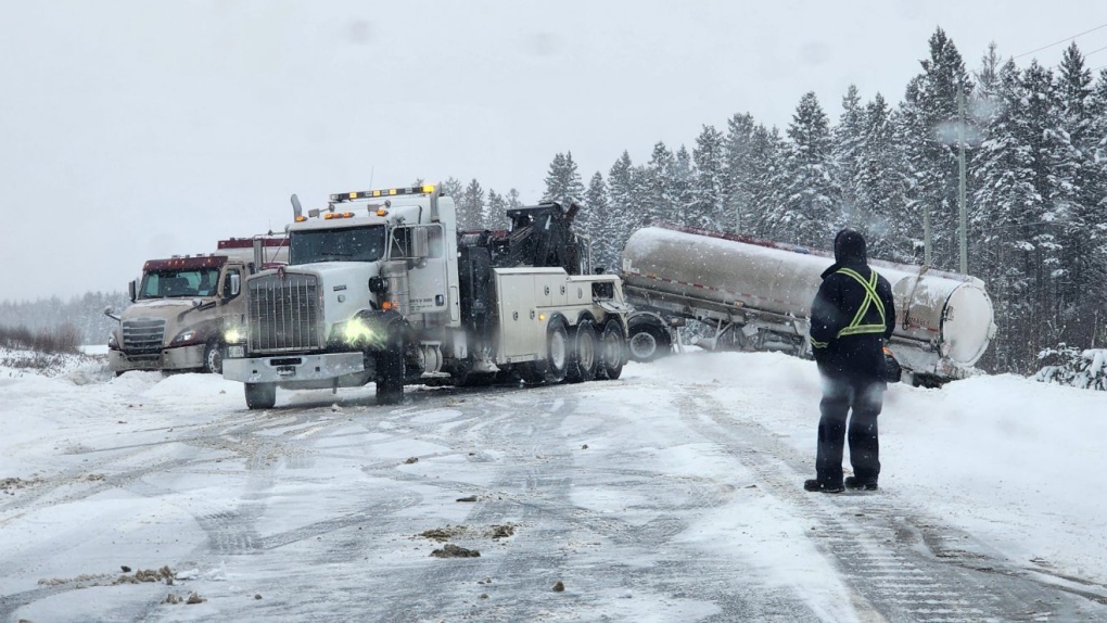 Single commercial vehicle crash has Hwy 11 closed north of Burk's Falls. Jan. 17/24 (Ontario Provincial Police)
"Almaguin Highlands OPP responded to a single motor vehicle collision involving a tractor trailer blocking the southbound lanes on Hwy. 11," the post said.
"No injuries."
The road reopened shortly after 3:30 p.m.
CTV News obtained video from Barbara Ashe who recorded several commercial trucks that had gone off the road on Highway 11 between Burk's Falls and Powassan.
One video shows a tanker on the wrong side of the road flanked by a tow truck and two OPP vehicles with lights flashing.
OPP acting Sgt. Phil Young is reminding all drivers to slow down and give yourself a little bit of extra time.
"We find that in a lot of these crashes, speed plays a pretty substantial factor. Of course the faster you go, the more time it will take you to brake," Young said.
EARLIER CRASHES
There were at least two other crashes on Highway 11 in the Temagami area Wednesday morning. Police have not released any details on those earlier crashes.
CTV News has confirmed one crash involved a school bus with children on board and a transport truck. No children were injured in the collision.
Another crash in the same area near Temagami occured Wednesday morning between a transport truck and a passenger vehicle.
Video obtained from the group Skilled Truckers Canada showed debris from that crash all over the road.
Meanwhile, weather alerts continue across the region as heavy and blowing snow create hazardous road conditions and visibility issues.
WEATHER ALERTS
Communities east of Georgian Bay are also under weather warnings for a third day due to intense snow squalls.
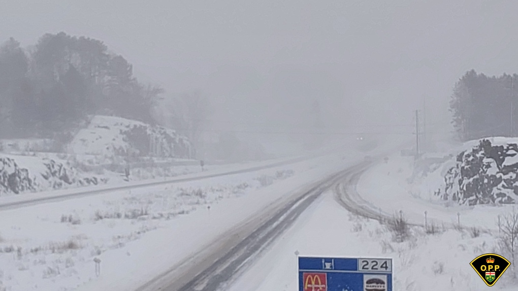 Snow squall on Highway 400 in Parry Sound. Jan. 17/24 (Ontario Provincial Police)
The snow squalls are expected to shift south and out of the region Wednesday evening.
In the Bayfield Inlet and Dunchurch areas, 10 to 15 cm of snow is expected with peak snowfall rates of two to four cm/h possible.
Further south in the Parry Sound area and east to Huntsville, total snowfall of 20 to 40 cm is expected by early Thursday morning with peak snowfall rates of more than five cm/h possible, Environment Canada said.
The system will not move out of the Parry Sound/Rosseau/Killbear Park area until Thursday morning as it continues to move south.
Even higher amounts of snow are expected in the Port Carling and Port Severn areas and east to Bracebridge and Gravenhurst with 25 to 50 cm being forecasted by Thursday morning, where a winter weather travel advisory is in effect.
Snow squalls in these communities are expected to start back up around noon following flurries Wednesday morning.
- Download the CTV News app now
- Get local breaking news alerts
- with the top local stories emailed to your inbox
In the Midland/Coldwater/Orr Lake areas, 15 to 20 cm of snow is expected through Thursday with snow squalls beginning later Wednesday afternoon as well.
LAKE NIPISSING
Winter weather travel advisories are in effect for North Bay, Powassan and Mattawa on Wednesday as well due to lake-effect snow.
The snow continues throughout the morning and is expected to taper off late Wednesday afternoon as the weather system moves south.
Five to 10 cm of more snow is expected for Jan. 17.
Heavy and blowing snow will affect visibility in this area.


CTVNews.ca Top Stories

Joly, Blair condemn anti-NATO protest in Montreal that saw fires, smashed windows
Federal cabinet ministers condemned an anti-NATO protest in Montreal that turned violent on Friday, saying 'hatred and antisemitism' were on display.
Canada's top general takes on U.S. senator in defending womens' role in combat units
Canada's top general firmly rejected the notion of dropping women from combat roles — a position promoted by president-elect Donald Trump's nominee for defense secretary — at a security forum underway in Halifax today.
Transit supervisor assaulted with 'torch' made of hairspray can and lighter: police
A Winnipeg man has been charged after a transit supervisor was assaulted with a makeshift torch in the city’s downtown area Friday morning.
NEW
NEW Thinking about taking an 'adult gap year'? Here's what experts say you should know
Canadian employees are developing an appetite for an 'adult gap year': a meaningful break later in life to refocus, refresh and indulge in something outside their daily routine, according to experts.
'Her shoe got sucked into the escalator': Toronto family warns of potential risk of wearing Crocs
A Toronto family is speaking out after their 10-year-old daughter's Crocs got stuck in an escalator, ripping the entire toe area of the clog off.
Canada's new income tax brackets in 2025: What you need to know
The Canada Revenue Agency has released updated federal income tax brackets for 2025, reflecting adjustments for inflation. Here’s the breakdown.
Canada's tax relief plan: Who gets a cheque?
The Canadian government has unveiled its plans for a sweeping GST/HST pause on select items during the holiday period. The day after the announcement, questions remain on how the whole thing will work.
Prime Minister Trudeau attends Taylor Swift's Eras Tour in Toronto with family
Prime Minister Justin Trudeau is a Swiftie. His office confirmed to CTV News Toronto that he and members of his family are attending the penultimate show of Taylor Swift's 'The Eras Tour' in Toronto on Friday evening.
Walking pneumonia is surging in Canada. Is it peaking now?
CTVNews.ca spoke with various medical experts to find out the latest situation with the typically mild walking pneumonia in their area and whether parents should be worried.
Shopping Trends
The Shopping Trends team is independent of the journalists at CTV News. We may earn a commission when you use our links to shop. Read about us.


Barrie
-

New Orillia Christmas tree shines bright
After Orillia’s underwhelming Christmas tree-lighting ceremony last year became a viral sensation, the City lit a new, bigger, brighter and healthier tree Friday evening.
-
Highway 400 reopens in Muskoka Lakes after fatal propane truck rollover
Highway 400 reopened late Friday night in Georgian Bay Township after emergency crews tended to a fatal tanker truck rollover Friday morning.
-
Drug trafficking investigation results in largest fentanyl seizure in Simcoe County: OPP
Two people are facing drug trafficking charges after what provincial police are calling the largest fentanyl seizure in Simcoe County.
Toronto
-

'Her shoe got sucked into the escalator': Toronto family warns of potential risk of wearing Crocs
A Toronto family is speaking out after their 10-year-old daughter's Crocs got stuck in an escalator, ripping the entire toe area of the clog off.
-
'Still working full time on it:' One year later police continue to search for gunman in Caledon double murder linked to ex-Olympian
One year after a couple was shot and killed in their Caledon home in what investigators have described as a case of mistaken identity, Ontario Provincial Police say they are still trying to figure out who pulled the trigger.
-
Swifties live-streaming Eras Tour concerts say they're part of a 'community'
Live streams of Taylor Swift’s sold-out Eras Tour concerts in Toronto give devoted fans a window into the spectacle of outfits, surprise songs and elaborate stages from one of the biggest cultural events in recent memory.
Ottawa
-

Ottawa councillor violated Code of Conduct for daycare incident last summer, integrity commissioner concludes
The City of Ottawa's integrity commissioner has found West-Carleton March Coun. Clarke Kelly has violated the Code of Conduct for city officials and should be reprimanded following an altercation with a local daycare owner and staff last summer.
-
Ottawa driver fined for hauling thousands of empty cans from trunk of car
Ontario Provincial Police stopped an Ottawa man for dangerously hauling thousands of empty cans from the back of his car.
-
290,000 speeding tickets and counting: A look at how many photo radar tickets have been issued in Ottawa in 2024
Photo radar cameras have caught nearly 300,000 speeders on Ottawa roads so far this year, as the City of Ottawa prepares to expand the automated speed enforcement camera program to another 39 locations over the next 14 months.
Kitchener
-

Advocates push for anti-renoviction bylaws as Waterloo Region reports affordable housing progress
On National Housing Day, housing advocacy group ACORN continued to push for anti-renoviction bylaws.
-
Man charged in Kitchener crash involving Grand River Transit LRT
Charges were laid after a crash between an LRT train and a Dodge vehicle shut down a busy Kitchener street for more than eight hours on Thursday.
-
How University of Waterloo researchers could help charge your devices by moving your body
Imagine being able to charge your devices through your body’s movements.
London
-

Nuclear operator helps fund affordable housing project in Goderich
The operators of the Bruce Nuclear Plant near Kincardine just donated $1 million towards Huron County’s largest affordable housing project in years.
-
video
video Thousands endure heavy rain to take in Hyde Park Santa Claus parade
Nearly 15,000 people lined Gainsborough Road in the pouring rain to take in the 16th Hyde Park Santa Claus parade and support a great cause.
-
Wingham area raises $3.6 million for new CT scanner
Wingham will be getting its first ever CT Scanner thanks to a multimillion dollar fundraising campaign that just came to a close.
Windsor
-

Truck fire on the Ambassador Bridge
Windsor fire responded to a transport truck fire on Friday afternoon on the Ambassador Bridge.
-
Highway 401 off ramp reopens
The OPP have confirmed an off ramp off Highway 401 has reopened.
-
4 Windsor, Chatham-Kent councillors oppose use of notwithstanding clause on encampments
Four councillors from Windsor and Chatham-Kent are among 72 municipal leaders opposing a letter from 15 Ontario mayors that supports Premier Doug Ford's push to use the notwithstanding clause to clear homeless encampments.
Montreal
-

Lucien-L'Allier train station to reopen Dec. 21 after renovations
Exo announced that Lucien-L'Allier train station will reopen on Dec. 21, with three commuter train lines – Vaudreuil/Hudson, Saint-Jérôme and Candiac – resuming service to the station.
-
Residents in Verdun evacuated after suspected arson
Montreal police (SPVM) said a dépanneur in Verdun was targeted in a suspected arson attack early Saturday morning.
-
Canada's new income tax brackets in 2025: What you need to know
The Canada Revenue Agency has released updated federal income tax brackets for 2025, reflecting adjustments for inflation. Here’s the breakdown.
Winnipeg
-

Snowfall warning in effect for southwestern Manitoba
Some areas could expect snowfall totals of 15 to 25 centimetres.
-
Have you seen George? RCMP search for missing senior
Spruce Plains RCMP are asking the public to help find 81-year-old George Haslen who has been missing since Friday afternoon.
-
The Thriftmas Special: The benefits of second-hand holiday shopping
The holidays may be a time for family, joy and togetherness, but they can also be hard on the wallet.
Atlantic
-

'We need answers': Protest held at RCMP detachment for missing N.B. man
A crowd of over 20 people stood in the pouring rain Saturday in front of the RCMP detachment in Hampton, N.B., to bring awareness to a missing person’s case.
-
Canada Post down eight million parcels amid strike as talk carry on over weekend
Canada Post says it has seen a shortage of more than eight million parcels amid the ongoing strike that has effectively shut down the postal system for nine days compared with the same period of 2023.
-
17-year-old dies following single-vehicle crash in Turtle Creek: N.B. RCMP
A 17-year-old boy from Petitcodiac, N.B., has died following a single-vehicle crash in Turtle Creek, N.B.
N.L.
-

As N.L. firm pivots, scientists say Canada's green hydrogen dreams are far-fetched
A Newfoundland energy company's embrace of data centres is raising doubts about eastern Canadian hopes of harnessing the region's howling winds to supply Germany with power from green hydrogen.
-
Canadian leads group pushing Vatican for zero-tolerance policy on abuse by clergy
An international group led by a Canadian is in Rome this week to push the Catholic Church to adopt a zero-tolerance policy on abuse by clergy.
-
Newfoundland wind-to-hydrogen company eyes data centre as international market lags
A company hoping to build a multi-billion-dollar wind-to-hydrogen project in western Newfoundland is eyeing other options as Canada's plans to supply Europe with green energy have not yet materialized.
Calgary
-

Snowfall warning for Calgary and southern Alberta expected to continue throughout Saturday
A snowfall warning for Calgary remained in effect early Saturday morning and looks poised to be hanging around all weekend.
-
Calgary activates transit detours amid snowfall warning
The City of Calgary's transit snow detours will be activated on Friday night, with the city expected to receive dozens of centimetres of snow.
-
‘Pinch me I’m dreaming:’ Calgary drummer pulled from crowd to play with the Arkells
For young musicians, to be up on stage in front of thousands of people, would be a dream come true. That’s exactly what happened to a Calgary girl, after being invited to play with Canadian rock icons The Arkells.
Edmonton
-

From Instagram to IRL: Where to find this year's trendy treats in Edmonton
From globally-inspired pastries to vegan fast food and Connor McDavid-themed culinary delights, Edmonton has a lot to offer anyone looking to try something trendy.
-
Man armed with knife arrested in west Edmonton: EPS
A man armed with a knife was arrested in west Edmonton Friday afternoon, police said.
-
Afraid of losing the U.S.-Canada trade pact, Mexico alters its laws and removes Chinese parts
Mexico has been taking a bashing lately for allegedly serving as a conduit for Chinese parts and products into North America, and officials here are afraid a re-elected Donald Trump or politically struggling Prime Minister Justin Trudeau could try to leave their country out of the U.S.-Mexico-Canada free trade agreement.
Regina
-

City of Regina releases snowfall response plan ahead of next blast of wintery weather
Many parts of Saskatchewan will be hit with another round of wintery weather on Saturday, and Regina is no exception, with up to 25 centimetres of snow expected to accumulate.
-
Here's a look inside the Globe Theatre before it reopens
The format is the same, but the venue looks very different from the last time audiences were inside Regina's Globe Theatre after extensive renovations.
-
B.C. man dies in collision on Sask. highway
A man from British Columbia has died in a two-vehicle collision on Highway 6 near Milestone, Sask.
Saskatoon
-

'I'm excited to take it on': Saskatoon businesses weigh in on GST exemption
Some local businesses say the federal government’s recent plan to pull back GST on several items is a positive initiative, but it should have been rolled out earlier in the holiday season.
-
Watermain break closes Saskatoon road
The City of Saskatoon is advising motorists of road closures due to a watermain break that caused flooding on Millar Avenue near Circle Drive.
-
Why isn't Saskatoon's new downtown shelter open yet?
Saskatoon's new downtown shelter must undergo renovations before it can open, according to the operator of the site.
Vancouver
-

Surrey crash sends 2 to hospital
Two people were taken to hospital after a serious crash in Surrey Friday night.
-
Fall legislative sitting scrapped in B.C. as Speaker Chouhan confirmed to serve again
There won't be a sitting of the British Columbia legislature this fall as originally planned.
-
SPS one week away from taking over Surrey policing
It’s been a long and drawn out process, but we are now a week away from Surrey’s new municipal force formally taking over policing responsibility in that city.
Vancouver Island
-

Fall legislative sitting scrapped in B.C. as Speaker Chouhan confirmed to serve again
There won't be a sitting of the British Columbia legislature this fall as originally planned.
-
Victoria police face being understaffed amid proposed budget cuts
Layoffs could be imminent for the Victoria Police Department if it adheres to the requests of the City of Victoria, and cuts over $2 million from its budget.
-
Campbell River high school closure extended due to fire
Carihi Secondary school in Campbell River is closed due to a fire on the property overnight – drawing a firefighting response from multiple departments and a crowd of onlookers.


