Wildfire west of Sudbury prompts evacuation order, total active fires in northern Ont. grows to 54
A northern Ontario forest fire that started west of Sudbury on Sunday morning has grown to more than 1,000 hectares and has prompted officials to issue an evacuation order for the immediate area as the number of active fires in the region grows.
Sudbury 17 is a wildfire that is located between RR810 and Mississagi Provincial Park and is not under control, the Ontario Ministry of Natural Resources said.
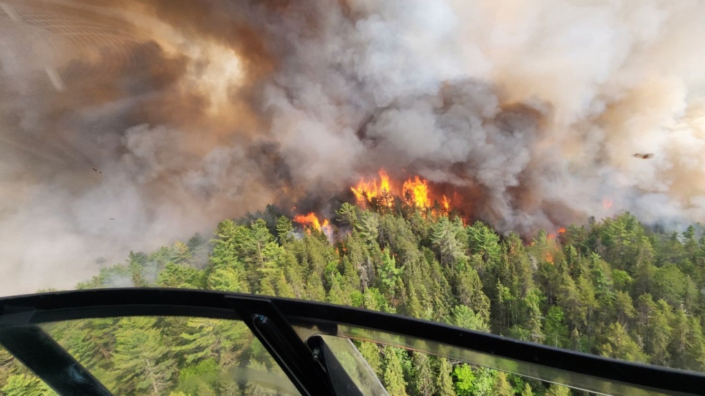 Sudbury 17, located about two kilometres west of RR810 east of Mississagi Provincial Park, has grown to 335 ha in two days. Aerial suppression happened June 4 and is still not under control. (Ministry of Natural Resources and Forestry)
It is north of the communities of Massey and Elliot Lake west of Sudbury.
"The fire is located north of Madaweson Lake. This fire has exhibited high to extreme fire behaviour, fire crews are conducting values protection and suppression is ongoing," MNRF said.
An emergency area order was declared for the following areas June 5:
"All persons must immediately evacuate the listed areas unless authorized by a travel permit issued by the MNRF:
- All travel and use of Highway 810 (also known as the Massey Tote Rd) north of the 17-mile crossover at UTM Zone 17 E 412333 N 5152544
- All travel and use of Highway 810 (also known as the Massey Tote Rd) south of Ritchie Falls at UTM Zone 17 E 403379 N 5177353
Wednesday evening, the evacuation area was expanded to:
"The townships of Olinyk, Plourde (south half), Prescott, Redden (west half), Strain, Teasdale, Poncet, Lehman, Lockeyer, Gerow and Gaiashik, unless authorized by a travel permit issued by the Ministry of Natural Resources and Forestry;
Specifically, all travel and use of Highway 553 (also known as the Massey Tote Rd) south of Cameron Creek at UTM Zone 17 E 408201 N 5136071, as outlined on the attached Implementation Order map within the EAO.
All travel and use of Pecors Rd at the Joubin, Gaiashik Township boundary at UTM Zone 17 E 389417 N 5136617, as outlined on the attached Implementation Order map within the EAO
All persons are prohibited from entering the area indicated on the attached map unless authorized by a travel permit issued by the Ministry of Natural Resources and Forestry."
Facing evacuations due to a forest fire or flood? Here's what to pack in a grab-and-go bag
All travel and use of the following areas is prohibited unless authorized by a travel permit issued by the Sudbury District MNRF:
- Highway 810 (also known as the Massey Tote Rd) north of the 17-mile crossover at UTM Zone 17 E 412333 N 5152544
- Highway 810 (also known as the Massey Tote Rd) south of the Ritchie Falls at UTM Zone 17 E 403379 N 5152544
- John’s Creek Rd at Porter Cree at UTM Zone 17 E 446601 N 5145635
- Fox Lake Rd at Centre Creek at UTM Zone 17 E 446870 N 5162934," the MNRF said.
Download our app to get local alerts on your device
Get the latest local updates right to your inbox
Travel, use and access restrictions put in place under an implantation order by the MNRF for the Hearst-Cochrane-Kapuskasing area on Saturday were expanded at 7 a.m. Tuesday.
Restrictions that were put in place May 31 in the Chapleau-Wawa area due to the Wawa 3 fire near White River are continuing.
FOREST FIRE UPDATE
As of Wednesday morning, the number of active forest fires in northern Ontario has reached 54 with 10 new wildfires Tuesday. Thirty of those active fires are not under control, an increase of seven from Tuesday.
There are 33 active forest fires in the northeast and 21 in the northwest.
In the last 24 hours, five new fires started in the northeast and seven started in the northwest.
The largest new fire in the northeast is Hearst 5 at 90 ha and it is not under control.
"The fire is located 36 kilometers south of Highway 11 and just north of Macvicar Creek," MNRF said Tuesday night.
There are 10 active fires in the northeast that are 100 ha or more:
- Wawa 3 near White River has grown to 6,678.1 ha
- Cochrane 7 has more than doubled in size in one day and sits at 4,256.4 ha
- Cochrane 6 remains at 1,239 ha
- Sudbury 17 tripled in size to 1,024 ha in one day
- Chapleau 3 grew from 80 ha to 700 ha in one day
- Chapleau 6 remains at 209 ha
- Sudbury 10 grew by more than 50 per cent to 120 ha
- Timmins 7 remains at 120 ha
- Wawa 2 remains at 105 ha and is now under control
Since the first Ontario forest fire April 12, 182 wildfires have started, 128 have been extinguished and more than 37,000 ha have burned.
SMOKE
Heavy smoke conditions continue in the northeast and is affecting the air quality.
"Smoke drift is travelling as far as north of Timmins, down through Sudbury and past Parry Sound," MNRF said.
Forest fire smoke can be harmful to your health, so officials recommend taking precautions to reduce exposure.
"See smoke and are unsure if you should call it in? Generally, if you see a column of smoke, give us a call at 310-FIRE (3473) if you’re located north of the French and Mattawa Rivers (or 911 if you’re south of these rivers); otherwise, check our interactive fire map or the above smoke-related websites to determine if what you’re seeing is drifting heavy smoke," MNRF said.
FIRE BANS IN EFFECT
Many northern Ontario communities have issued municipal fire bans in addition to the regionally restricted fire zone that went into effect June 1.
This prohibits open-air burning, including campfires.
"Portable gas or propane stoves may be used for cooking and warmth but must be handled with extreme caution. All burning permits are suspended," MNRF said.
Failure to comply with the fire ban could result in a fine of up to $25,000, three months in jail and financial responsibility for any costs incurred in fighting a forest fire caused by the illegal blaze.
PLANES AND DRONES
Residents are asked to stay clear of waterbombers that scoop up water from area lakes.
"If you see one flying overhead while fishing or enjoying time on the water, move to shore as safely as possible to allow room for them to perform their scoop," MNRF said on social media.
Officials are also reminding people it is illegal to fly a drone within nine kilometres of a wildfire, as it is dangerous for firefighters and pilots.
More details can be found on the ministry's forest fire page.


CTVNews.ca Top Stories
'I just can't believe that it took so long': Body found in wreckage 3 months after deadly fire
A man accused of arson in a January Old Strathcona apartment fire is expected to be charged with manslaughter after a body was discovered in the burned building late last month.
No proof man lied to brother about number of kittens born in litter, B.C. tribunal rules
A man was denied a $5,000 payout from his brother after a B.C. tribunal dismissed his claim disputing how many kittens were born in a litter.
Quebec police hand out hundreds of tickets to Hells Angels and other bikers before 'first run' meeting
Quebec provincial police handed out hundreds of fines to Hells Angels members and other supporting motorcycle clubs who met for their 'first run' in a small town near Sherbrooke, Que.
Feds hope to table foreign interference legislation next week: LeBlanc
Democratic Institutions Minister Dominic LeBlanc says he plans to table legislation this week to help the federal government address foreign interference, but he wouldn't say whether the proposal will include a foreign agent registry.
Auston Matthews skates ahead of Game 7, status unclear with season on the line
Centre Auston Matthews of the Toronto Maple Leafs hasn't been ruled out of tonight's Game 7 against the Boston Bruins.
Snakes almost on a plane: U.S. TSA discovers a bag with small snakes in passenger's pants
According to an X post by the Transportation Security Administration, officers at the Miami International Airport found the small bag of snakes hidden in a passenger's trousers on April 26 at a checkpoint.
A Chinese driver is praised for helping reduce casualties in a highway collapse that killed 48
A Chinese truck driver was praised in local media Saturday for parking his vehicle across a highway and preventing more cars from tumbling down a slope after a section of the road in the country's mountainous south collapsed and killed at least 48 people.
Russia puts Ukrainian President Zelenskyy on its wanted list
Russia has put Ukrainian President Volodymyr Zelenskyy on its wanted list, Russian state media reported Saturday, citing the interior ministry’s database.
Grandparents killed in wrong-way crash on Hwy. 401 identified
A 60-year-old man and a 55-year-old woman killed in a wrong-way crash on Highway 401 earlier this week have been identified by the Consulate General of India in Toronto.
Shopping Trends
The Shopping Trends team is independent of the journalists at CTV News. We may earn a commission when you use our links to shop. Read about us.


Barrie
-
Two people charged as OPP recover stolen firearm in Orillia
OPP have laid multiple firearms related charges against two individuals in Orillia.
-
Man in custody after alleged intimate partner violence
A Barrie man is facing multiple charges related to incidents of intimate partner violence that originated in the Township of Essa.
-
Hunreds take part in the annual Charlee's run fundraiser
The annual Charlee's run fundraiser returned to Orillia on Saturday.
Toronto
-

Auston Matthews skates ahead of Game 7, status unclear with season on the line
Centre Auston Matthews of the Toronto Maple Leafs hasn't been ruled out of tonight's Game 7 against the Boston Bruins.
-
Man, 49, arrested after deadly stabbing in Brampton
A 49-year-old man has been arrested following a deadly stabbing in Brampton earlier this month.
-
Police investigating stabbing in Rexdale that sent man to hospital
A man is in hospital after being stabbed in Rexdale Saturday afternoon.
Ottawa
-

Firefighters battle second Overbrook highrise blaze on Donald Street
Ottawa Fire Services say crews battled a fire that broke out in the bedroom of an Overbook highrise on Friday evening - less than 48 hours after a fire in the same building displaced hundreds of residents and sent three people to hospital in critical condition on Thursday.
-
Outdoor Farmers' Market back in Ottawa this May
The Ottawa Farmers' Market is bringing back its outdoor markets this May, featuring fresh produce sold by local vendors across five different locations in the city.
-
Hintonburg coffee shop closes for 'unforeseen circumstances'
Hintonburg's Ministry of Coffee will be closed until further notice due to "unforeseen circumstances," the popular Ottawa coffee shop said Saturday.
Kitchener
-

WRDSB to lay off 106 elementary school teachers
More than 100 teachers at the Waterloo Region District School Board (WRDSB) are learning they have been declared surplus will likely be out of a job as of Aug. 12.
-
Chemical spill could be cause of stinky water in Puslinch, Ont., new report says
People living in Puslinch, Ont. may have the answer to why their water smelled so bad last year.
-
Grandparents killed in wrong-way crash on Hwy. 401 identified
A 60-year-old man and a 55-year-old woman killed in a wrong-way crash on Highway 401 earlier this week have been identified by the Consulate General of India in Toronto.
London
-

May the 4th strikes back: Geeks and Co. holding Star Wars event to raise money for charity
May the 4th traditionally marks Star Wars Day, and some London, Ont. area fanatics are expressing their love for the movie franchise.
-
Olympic talent scouts arrive in the Forest City for annual 'RBC Training Ground'
The Canadian Olympic Committee hosted a free talent search in London, Ont. Saturday.
-
CTV News London's top stories from this week
In case you missed it, CTV News London has compiled all the top local stories from this week into one video for your convenience.
Windsor
-

Windsor theatre performer hopes locally-shot original comedy series changes perception of people with disabilities
In the few years since he became completely blind and lost both of his legs in back-to-back amputations, Michael Potter says he is used to people treating him differently — almost to the point of insulting.
-
CTV News Windsor's top stories from this week
In case you missed it, CTV News Windsor has compiled all the top local stories from this week into one video for your convenience.
-
Teen charged in connection with armed robbery
The Windsor Police Service has arrested a 17-year-old boy following an armed robbery in the city’s west end.
Montreal
-

Despite shift to EVs, number of gas-powered cars on Quebec roads hits record high
The province has been pushing drivers to make the switch to electric vehicles (EVs) but it appears Quebecers aren't buying in. The latest numbers from the SAAQ show that the number of gas-powered vehicles hit a record high in 2023.
-
Quebec police hand out hundreds of tickets to Hells Angels and other bikers before 'first run' meeting
Quebec provincial police handed out hundreds of fines to Hells Angels members and other supporting motorcycle clubs who met for their 'first run' in a small town near Sherbrooke, Que.
-
Explosion at train station leads to discovery of stolen car on Montreal's South Shore: police
Police are investigating after a BMW exploded in the St-Lambert Exo train station parking lot on Montreal's South Shore.
Winnipeg
-

15-year-old boy charged with second-degree murder in Lake St. Martin First Nation shooting
A 15-year-old boy from Lake St. Martin First Nation has been charged with second-degree murder after a fatal shooting earlier this week.
-
Pro-Palestinian encampment coming to the University of Manitoba next week
A pro-Palestinian encampment is expected to be set up at the University of Manitoba next week, in light of similar protests across Canada and the United States.
-
Woman charged with manslaughter following death in Sioux Valley Dakota Nation
RCMP have charged a 29-year-old woman with manslaughter in connection to the death of a man in Sioux Valley Dakota Nation earlier this year.
Atlantic
-

Nova Scotia NDP leader says party is election ready, announces housing plan
Nova Scotia's NDP leader announced a program aimed at easing the cost of housing during a rousing campaign-style speech before the party's annual convention in Halifax today.
-
15-year-old boy dies following ATV collision: N.B. RCMP
A 15-year-old boy, from the Bathurst region, has died following an all-terrain vehicle (ATV) collision in Beresford, N.B.
-
Upper Musquodoboit man dies after car leaves road: N.S. RCMP
RCMP said they responded to a report of a single motor vehicle crash on Highway 289 on Wednesday around 10:09 p.m.
N.L.
-

Funeral today for broadcasting legend and voice of 'Hockey Night in Canada' Bob Cole
A funeral is being held today for hockey broadcasting legend Bob Cole in his hometown of St. John's, N.L.
-
Newfoundland fisherman says police broke his leg during protest that delayed budget
Richard Martin is spending this year's fishing season on land after he says a Royal Newfoundland Constabulary officer broke his left leg in three places during a protest last month that shut down the provincial legislature.
-
'I feel honoured to say I was his friend': Wayne Gretzky remembers Bob Cole
Tributes continue to pour in for Bob Cole as his family has confirmed a funeral will be held for the legendary broadcaster Friday in St. John's, N.L.
Calgary
-

Work stoppage possible as WestJet issues lockout notice to maintenance engineers' union
A lockout notice issued by WestJet to a union representing aircraft maintenance engineers could result in a work stoppage next week.
-
Netflix is filming a western series in Calgary starting this month
Netflix is set to begin filming a western series with a star-studded cast in Calgary this month. The Abandons, created by Kurt Sutter from Sons of Anarchy fame, follows “a group of diverse renegade families living on the fringes of society in 1850s Oregon.”
-
TransAlta cancels wind power project over new government rules on development
A major Alberta utility has cancelled a large wind power project in response to new government rules on where such developments can be built.
Edmonton
-

Oilers to face Canucks in second round of NHL playoffs
The Edmonton Oilers will face the Vancouver Canucks in the second round of the National Hockey League post-season after Vancouver advanced with a 1-0 win over the Nashville Predators in Game 6 Friday, winning the best-of-seven opening-round series 4-2.
-
Netflix is filming a western series in Calgary starting this month
Netflix is set to begin filming a western series with a star-studded cast in Calgary this month. The Abandons, created by Kurt Sutter from Sons of Anarchy fame, follows “a group of diverse renegade families living on the fringes of society in 1850s Oregon.”
-
'I just can't believe that it took so long': Body found in wreckage 3 months after deadly fire
A man accused of arson in a January Old Strathcona apartment fire is expected to be charged with manslaughter after a body was discovered in the burned building late last month.
Regina
-

Piece of Regina military history makes its way to France
A plane bound for Juno Beach in France took off from the Prairies on Friday with a piece of military history.
-
Human remains found in rural Sask. possibly a decade old, RCMP say
RCMP say human remains found in a rural area in central Saskatchewan may have been there for a decade or more.
-
Some sunshine on the way for Regina this weekend
After some gloomy and rainy days in the Queen City, there will be some sunshine heading into the weekend.
Saskatoon
-

Winnipeg man wanted for murder arrested in Saskatoon
A 28-year-old Winnipeg man wanted for murder was arrested near Boychuk Drive and Briarwood Road in Saskatoon.
-
Deflated for now, Saskatoon's Golf Dome is about to get a makeover
A lesser known fixture of Saskatoon's skyline is coming down for repairs and renovations.
-
Minten’s dagger halts Warriors' late-game comeback, chance to advance for Blades
The WHL Eastern Conference Final between the Saskatoon Blades and Moose Jaw Warriors has been full of see-saw momentum shifts, heart-stopping moments, and overtime heroes. Game 5 had all of the above.
Vancouver
-

1 dead, 1 arrested at rural property in Mission, B.C.
Homicide investigators have been called to Mission, B.C., after a man died Friday night.
-
Scorpion venom research company did not commit misconduct, B.C. regulator rules
A Vancouver-based health sciences company that was attempting to develop synthetic scorpion venom withheld relevant information from investors, but that omission did not necessarily have an impact on the company's stock price, B.C.'s financial regulator has ruled.
-
Red dresses to make fashion statement about missing and murdered Indigenous women
Models in uniquely designed red dresses are taking to the runway in British Columbia this weekend to make a powerful fashion statement about missing and murdered Indigenous women, girls and two-spirit people.
Vancouver Island
-

No proof man lied to brother about number of kittens born in litter, B.C. tribunal rules
A man was denied a $5,000 payout from his brother after a B.C. tribunal dismissed his claim disputing how many kittens were born in a litter.
-
Red dresses to make fashion statement about missing and murdered Indigenous women
Models in uniquely designed red dresses are taking to the runway in British Columbia this weekend to make a powerful fashion statement about missing and murdered Indigenous women, girls and two-spirit people.
-
Suter scores late goal, clinches series for Canucks
Pius Suter scored with 1:39 left and the Vancouver Canucks advanced to the second round of the NHL playoffs with a 1-0 victory over the Nashville Predators on Friday night in Game 6.


