Weather warnings across northern Ont.: Freezing rain, snow
A messy storm bringing wintery weather across northern Ontario is expected to create hazardous conditions in a large portion of the region Thursday and Friday.
Environment Canada upgraded its weather alerts to snowfall and freezing rain warnings for communities stretching from the Quebec-Ontario border, north of Lake Superior and west to the Manitoba border.
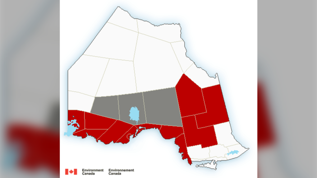 Environment Canada Northern Ontario weather alert map Nov. 10/22
A developing low-pressure system will begin Thursday morning and continue into Friday.
FREEZING RAIN WARNINGS
As temperatures hover around freezing, precipitation is expected to bring 20-50 mm of rain, five to 10 mm of ice accretion and two to five cm of ice pellet accumulations in these areas:
- Atikokan - Shebandowan - Quetico Park
- Chapleau - Missinaibi Lake
- Cloud Bay - Dorion
- Kakabeka Falls - Whitefish Lake - Arrow Lake
- Marathon - Schreiber
- Nipigon – Rossport
- Thunder Bay
- Timmins - Cochrane - Iroquois Falls
- Wawa - Pukaskwa Park
- White River - Dubreuilville
SNOWFALL WARNINGS
Significant snowfall will begin in some areas Thursday morning and bring nearly 15 centimetres of snow.
"The heaviest snow is expected to fall this evening into Friday morning. Snow is likely to mix with ice pellets at times during this period," Environment Canada said in a weather alert Thursday morning.
There is a danger of reduced visibility in heavy and blowing snow.
Here are the communities affected:
- Dryden - Vermilion Bay
- Fraserdale - Pledger Lake
- Ignace - English River
- Kapuskasing - Hearst - Smooth Rock Falls
- Kenora - Grassy Narrows – Whitedog
- Little Abitibi - Kesagami Lake
- Seine River Village - Mine Centre
RAINFALL WARNINGS
North of Sault Ste. Marie, in the Agawa and Lake Superior Park areas, heavy rain will continue with a total accumulation of 50 to 70 mm by Friday morning.
"Precipitation in the form of rain is expected to continue today along with the risk of embedded thunderstorms," Environment Canada said.
"(Thursday night) the rain is expected to continue, however, there is the potential that the rain could fall as freezing rain over areas of higher terrain. By Friday morning, the freezing rain threat diminishes and rain is expected to taper off."
WINTER STORM WARNING
Closer to the Manitoba-Ontario border snowfall of 15 to 25 centimetres is expected by Friday.
Strong wind gusts will create blowing snow and reduced visibility, Environment Canada said.
"Snowfall rates of near two cm per hour possible in the heaviest snow," the weather alert said.
"Consider postponing non-essential travel until conditions improve. Public Safety Canada encourages everyone to make an emergency plan and get an emergency kit with drinking water, food, medicine, a first-aid kit and a flashlight."
Areas affected include:
- Fort Frances, Emo and Rainy River
- Sioux Narrows - Nestor Falls – Morson
WINTER WEATHER TRAVEL ADVISORIES
Communities north of Lake Superior and Highway 11 should see seven to 12 centimetres between Thursday and Friday afternoon.
Including:
- Armstrong - Auden - Wabakimi Park
- Nakina - Aroland – Pagwa
- Savant Lake - Sturgeon Lake
- Sioux Lookout - Eastern Lac Seul
Find the current weather conditions and seven-day forecast for your community here.


CTVNews.ca Top Stories

'Anything to win': Trudeau says as Poilievre defends meeting protesters
Prime Minister Justin Trudeau is accusing Conservative Leader Pierre Poilievre of welcoming 'the support of conspiracy theorists and extremists,' after the Conservative leader was photographed meeting with protesters, which his office has defended.
What is changing about Canada's capital gains tax and how does it impact me?
The federal government's proposed change to capital gains taxation is expected to increase taxes on investments and mainly affect wealthy Canadians and businesses. Here's what you need to know about the move.
'My stomach dropped': Winnipeg man speaks out after being criminally harassed following single online date
A Winnipeg man said a single date gone wrong led to years of criminal harassment, false arrests, stress and depression.
Bank of Canada officials split on when to start cutting interest rates
Members of the Bank of Canada's governing council were split on how long the central bank should wait before it starts cutting interest rates when they met earlier this month.
Pilot reported fire onboard plane carrying fuel, attempted to return to Fairbanks just before crash
One of the two pilots aboard an airplane carrying fuel reported there was a fire on the airplane shortly before it crashed and burned outside Fairbanks, killing both people on board, a federal aviation official said Wednesday.
'One of the single most terrifying things ever': Ontario couple among passengers on sinking tour boat in Dominican Republic
A Toronto couple are speaking out about their 'extremely dangerous' experience on board a sinking tour boat in the Dominican Republic last week.
Quebec nurse had to clean up after husband's death in Montreal hospital
On a night she should have been mourning, a nurse from Quebec's Laurentians region says she was forced to clean up her husband after he died at a hospital in Montreal.
7 surveillance videos linked to extortions of South Asian home builders in Edmonton released
The Edmonton Police Service has released a number of surveillance videos related to a series of extortion cases in the city now dubbed 'Project Gaslight.'
Ukraine uses long-range missiles secretly provided by U.S. to hit Russian-held areas, officials say
Ukraine for the first time has begun using long-range ballistic missiles provided secretly by the United States, bombing a Russian military airfield in Crimea last week and Russian forces in another occupied area overnight, American officials said Wednesday.
Shopping Trends
The Shopping Trends team is independent of the journalists at CTV News. We may earn a commission when you use our links to shop. Read about us.


Barrie
-

Suspected remains of missing Thornbury man found six years after disappearance
It was mid-October 2018 when Eric Spencer was last seen in Honey Harbour, a full-scale search by the OPP for the then 60-year-old from Thornbury scaled back when the search came up empty.
-
Video surveillance footage reveals bizarre break-in at local vet hospital
Barrie Police laid charges on a man after video surveillance captured him breaking into a store and smashing the front glass door.
-
Impaired driver fails breathalyzer test: OPP
Police laid impaired driving charges following a traffic stop in Brockton on Tuesday evening.
Toronto
-

Speed limits to increase on some sections of Ontario highways, province says
The Ontario government says it will be raising the speed limit along certain stretches of provincial highways soon, including Highway 401 and Highway 403.
-
New condo sales in the Toronto area hit low not seen since financial crisis
New condo sales in the Toronto region dropped to the lowest quarterly total since the financial crisis in 2009 amid high interest rates and affordability issues, a new report has found.
-
'One of the single most terrifying things ever': Ontario couple among passengers on sinking tour boat in Dominican Republic
A Toronto couple are speaking out about their 'extremely dangerous' experience on board a sinking tour boat in the Dominican Republic last week.
Ottawa
-

NCC buys golf course near Gatineau Park for $3.9 million
The National Capital Commission has purchased the old Dunnderosa Golf Course in Chelsea, Que., as part of its plan to acquire private properties in Gatineau Park.
-
City planning committee approves study into anti-renovictions bylaw
Councillors have approved a motion that would study the possibility of an anti-renovictions bylaw, which tenant advocates say would help to prevent frivolous evictions.
-
Ontario to increase speed limit on Hwy. 416 to 110 km/h
Beginning this summer, the speed limit will increase from 100 km/h to 110 km/h on approximately 70 kilometres of Hwy. 416 between Hwy. 401 and Ottawa.
Kitchener
-

Undisclosed project filming in Cambridge today
Expect delays on Queen Street in Cambridge today as film crew shoots in the area.
-
Pedestrian seriously hurt after crash in Kitchener
A pedestrian had to be taken to an out-of-region hospital following a crash in Kitchener.
-
Grand River and St. Mary's hospitals could merge in 2025
Grand River Hospital and St. Mary’s General Hospital are looking to merge into a single new hospital organization by the spring of 2025.
London
-

How do U.S. decisions about TikTok impact Canada?
U.S. President Joe Biden has signed a bill that will force TikTok to be sold or be banned in his country, but what does it mean for Canada?
-
'I think 110 is fast enough': Speed limit to increase on some sections of 400 series highways
The speed you travel on sections of 400 series highways in our region is increasing. The province says it will raise the speed limit to 110 km/h on multiple sections, including some in the London region.
-
London, Ont. natives help Knights carry perfect record into Conference Final series with Saginaw
The London Knights went out in the offseason and acquired the goaltender they believed could lead them to a championship. So far, so good as Michael Simpson is a perfect 8-0 in the post season.
Windsor
-

Essex concert series needs to pay its performers, say local musicians
If musicians are the sole focus of a commercial event, those performers should be paid for their efforts. That's according to a local musician who set up an online petition after the Town of Essex issued a call for artists to perform at their annual summer concert series for free.
-
Witnesses sought after Porsche and motorcycle collide
The Windsor Police Collision Reconstruction Unit is looking for witnesses after a collision involving a motorcycle and a Porsche.
-
Man arrested after police seize $10,000 in drugs
A 42-year-old man has been arrested after police seized $10,000 in illegal drugs.
Montreal
-

Quebec nurse had to clean up after husband's death in Montreal hospital
On a night she should have been mourning, a nurse from Quebec's Laurentians region says she was forced to clean up her husband after he died at a hospital in Montreal.
-
'Highly complex' work delays REM completion to West Island, North Shore
The completion of Montreal's Reseau express metropolitain has been postponed yet again.
-
Quebec grants $40 million for cleanup of Montreal Olympic Stadium after fire
The Quebec government has awarded the organization that manages Montreal's Olympic Stadium up to $40 million to pay for repairs and decontamination after a March 21 fire.
Winnipeg
-

Manitoba government tables bill to end ban on homegrown recreational cannabis
Manitoba is planning to lift its ban on the home growing of recreational cannabis.
-
'I just wanted to stand out': Winnipeg Jets fan goes viral for wearing salmon shirt at Whiteout
A Winnipeg Jets fan found a unique way to stand out amid the Winnipeg Whiteout; he wore a salmon-coloured shirt.
-
Child dies following collision with trailer: Brandon police
A four-year-old child has died following a collision with a trailer in Brandon, Man.
Atlantic
-

Funeral to be held Wednesday for 16-year-old Halifax homicide victim
A funeral will be held Wednesday afternoon in Bedford, N.S., for a 16-year-old boy who died earlier this week following an incident near the Halifax Shopping Centre.
-
Cape Breton man earns $1.5M in Scratch’N Win
A Cape Breton man won $1.5 million after buying $200-worth of Atlantic Lottery Scratch’N Win tickets.
-
Police presence at Lower, Middle Sackville, N.S., schools Wednesday afternoon
RCMP officers were seen at three schools in Lower and Middle Sackville, N.S., Wednesday afternoon.
N.L.
-

Rideshare platform Uber expands to Newfoundland and Labrador
Uber Technologies Inc. says it has brought its ridesharing platform to Newfoundland and Labrador.
-
Newfoundland director found creeping terror of 'The King Tide' in a tiny coastal town
Newfoundlander Christian Sparkes has shot several films around his home province, but with his new psychological thriller 'The King Tide' he saw an opportunity to wander into one unique town that had eluded him over the years.
-
2 people dead, 4 others make it to shore after vessel capsizes in Newfoundland
The Department of Fisheries and Oceans says two people were found dead and four others survived after a boat capsized off the west coast of Newfoundland.
Calgary
-

'Disingenuous and misleading': Calgary mayor, province at odds over plan to lower utility bills
Calgary's mayor is sparring with the Government of Alberta over the rollout of new legislation meant to lower utility bills in Calgary.
-
Bell no longer a Calgary Stampede sponsor after nearly 20 years
Bell Canada, the parent company of CTV News, is no longer a sponsor of the Calgary Stampede.
-
Investigation leads to recovery of stolen truck, tilt deck and skid steer
Officers with Southern Alberta’s district crime reduction unit were investigating property crime in Mountain View County when they recovered a substantial amount of it.
Edmonton
-

7 surveillance videos linked to extortions of South Asian home builders in Edmonton released
The Edmonton Police Service has released a number of surveillance videos related to a series of extortion cases in the city now dubbed 'Project Gaslight.'
-
All Alberta wildfires to date in 2024 believed to be human-caused: province
There are 63 wildfires burning in Alberta's forest protection area as of Wednesday morning and seven mutual aid fires, including one in the Municipal District of Peace.
-
8.9% property tax approved by Edmonton council
Edmonton city council unanimously agreed on an 8.9-per cent property tax increase Tuesday evening.
Regina
-

Throwing star, crossbow found during Sask. RCMP searches at George Gordon FN, Punnichy
A throwing star and crossbow were among the seizures by police as part of a drug trafficking investigation on George Gordon First Nation and in Punnichy, Sask. last week.
-
Sask. police caught 454 impaired drivers in March: SGI
Saskatchewan police caught 454 impaired drivers around the province in March. Of those, 142 are facing Criminal Code charges and the other 312 faced licence suspensions, according to a news release from Saskatchewan Government Insurance (SGI).
-
Saskatchewan to update aging air tanker fleet beginning in 2025
The Government of Saskatchewan has purchased four re-purposed Dash-8 airliners to replace elements of its air tanker fleet in the next three years.
Saskatoon
-

Sask. woman fights to find out who had her apprehended for a psych. assessment
A Saskatchewan woman who was taken for an involuntary mental health assessment is entitled to find out who had her committed, a provincial court judge has ruled.
-
Punched, kicked, spat on: Saskatoon Transit workers call for help after violent assaults
The union representing the city’s bus drivers says violence against transit workers is out of control.
-
Saskatoon man turned himself in after violent stabbing
A 25-year-old Saskatoon man faces charges in relation to a stabbing that left a 34-year-old man in hospital on Tuesday.
Vancouver
-

Fatal stabbing near White Rock promenade under investigation: RCMP
A homicide is under investigation in White Rock, B.C., marking the second stabbing near the waterfront promenade in a 48-hour period.
-
RCMP officers 'refused' to provide evidence to Crown to assist drug, firearms prosecution: report
Crown counsel was unable to approve "significant" drug and weapons charges stemming from an arrest in Quesnel, B.C., last year because the officers involved "refused to provide any evidence," according to a report from the province’s police watchdog.
-
Brothers Keepers gang member in B.C. sentenced to 11 years in prison
A member of the Brothers Keepers gang in British Columbia, which police describe as an 'extremely violent organized crime group,' has been sentenced to 11 years in prison on drug-trafficking charges.
Vancouver Island
-

Brothers Keepers gang member in B.C. sentenced to 11 years in prison
A member of the Brothers Keepers gang in British Columbia, which police describe as an 'extremely violent organized crime group,' has been sentenced to 11 years in prison on drug-trafficking charges.
-
Mounties will not be charged in shooting death of B.C. Indigenous man
Three Mounties in British Columbia will not face charges in the killing of a 38-year-old Indigenous man on Vancouver Island in 2021.
-
Vancouver Island man realizes childhood dream alongside Hollywood icon
To appreciate the two posters hanging in Stephen Campanelli’s laundry room, which he’s had for more than 40 years, you need to know he’s been a Clint Eastwood fan for even longer.


