Video shows northern Ont. storm hammer shoreline, breaking dock
The owner of a northern Ont. camp is continuing to clean up after an intense storm that prompted a tornado warning Thursday ripped through the area breaking his dock and downing trees.
Trevor Graydon of Mowat Landing Cottages on the Montreal River in New Liskeard, near the Quebec border, captured video of the rain, hail and heavy winds pummelling his shoreline the afternoon of June 13.
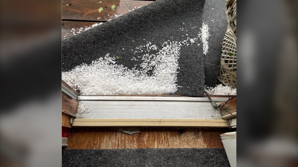
The fast-moving storm brought severe thundershowers to the area and prompted Environment Canada to issue weather alerts shortly before 3 p.m. warning of nickel- to ping pong ball-sized hail and up to 90 km/h wind gusts.
Heavy rain and wind pushing waves ashore on the usually peaceful waters can be seen intensifying before swirling and flying debris takes flight in the nearly two-minute video.
"Never seen an aqua blue sky like that," Graydon said in a post on social media.
Melanie Aquino Ducharme commented that the sky turned aqua blue, orange and fuschia in Haileybury during the storm.
A float plane can be seen docked at the beginning of the video footage and appears to end up along the shoreline after the dock breaks off and washes ashore.
 Storm damage in New Liskeard, Ont.
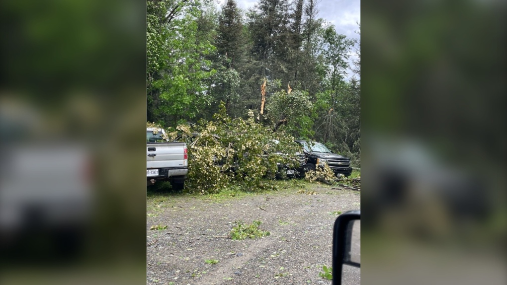
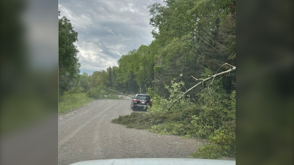
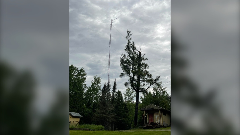
Several trees around the property were taken out by the storm and caused damage to some vehicles, Graydon said.
 Storm damage in New Liskeard, Ont.
 Storm damage in New Liskeard, Ont.
 Storm damage in New Liskeard, Ont.
One of the downed trees was 160 feet tall, he said, but luckily, no one was injured and the plane is OK.
 Storm damage in New Liskeard, Ont.
PHOTO GALLERY: Damage left behind at Mowat Landing Cottages
The roads are cleared as of Saturday afternoon and cleanup is almost done, Graydon added.
His video of the storm posted on social media has garnered more than 26,000 views.
 Storm damage in New Liskeard, Ont.
Lesley Elliott, a research meteorologist for the Northern Tornadoes Project, told CTV News in an email that based on the video, the storm looks like a weak downburst.
"We have been reviewing witness and damage reports from the storms on the 13th and will start reviewing satellite imagery of the storm tracks as it becomes available," Elliott said.
"We have seen the report of trees down nearby and this is an area slated for satellite imagery review as well. Once we have enough information, we should be able to estimate a max. wind speed based on the damage."
Two Ontario tornadoes
No tornadoes have been confirmed yet as a result of Thursday's storm, but the Northern Tornadoes Project is reporting two 'over land' tornadoes earlier in June.
One reportedly happened June 4 in the northwest around 6:35 p.m.
"Satellite imagery review of a storm track of interest revealed tornado damage in forested areas near Landings Lake, north of Lac Seul," NTP said in its map.
"Tornado damage is assessed as EF2, with an estimated max wind speed of 190 km/h, track length of 5.67 km and max path width of 350 m.
On the afternoon of June 6, an EF0 tornado was recorded south of Ottawa.
"A tornado caused weak tree and crop damage south of Spencerville, where a section of the damage track was documented by a private citizen," NTP said.
"No injuries were reported."
A ground and drone survey was completed by NTP over the two days following the storm.
The tornado had an estimated max wind speed of 115 km/h, track length of 6.83 km and max path width of 250 m.
CTVNewsNorthernOntario.ca has reached out to the Northern Tornadoes Project about Thursday's storm and is awaiting a response.


CTVNews.ca Top Stories

Job losses and killer robots: The 'Godfather of AI' describes plenty to fear, but there may be room for hope
University of Toronto computer scientist Geoffrey Hinton describes plenty to fear with AI, but with visions of combat drones, mass surveillance and robot overlords ahead, there may be space for hope.
'I'm sorry, I'm just frustrated': Video appears to show man spit on MP
A video circulating online appears to show MP and former cabinet minister Marco Mendicino get spat on while on his way into a government building in Ottawa.
4 people found dead in southwestern Ontario town of Harrow
Ontario Provincial Police are investigating after four people were found dead in the town of Harrow, just south of Windsor. Officers were called to a residence on County Road 13 at approximately 1:30 p.m. on Thursday.
More than 100 stolen vehicles recovered in auto theft probe involving ServiceOntario employee: Toronto police
Toronto police say they have arrested four suspects and recovered more than 100 stolen vehicles as part of a months-long auto theft probe that involved a former ServiceOntario employee.
EXCLUSIVE
EXCLUSIVE 'We were in danger': Timmins, Ont., manhunt prompts questions from cottagers near shootout
Cottagers who live near the area where murder suspect Lucas MacDonald was captured say they didn't realize how much danger they were in.
Car dealerships in Canada, U.S. disrupted by multi-day outage after cyberattacks
CDK Global, a company that provides software for thousands of auto dealers in the U.S. and Canada, was hit by back-to-back cyberattacks on Wednesday. That led to an outage that continued to impact many of their operations on Friday.
Shiny monolith removed from mountains outside Las Vegas. How it got there is still a mystery
A strange monolith found jutting out of the rocks in a remote mountain range near Las Vegas has been taken down by authorities.
It's the longest bridge ever built in Peru, and so far, it goes nowhere
It is the longest bridge ever built in Peru, a massive structure of cement and iron spanning the Nanay River as it connects to untouched areas of the Peruvian Amazon. So far, it goes nowhere.
Skin cancer signs: How can you tell if a suspicious spot is serious?
Doctors say changes in the skin are normal as you age, from spots of various colours to dark streaks in nails. But sometimes, they're not innocuous.
Shopping Trends
The Shopping Trends team is independent of the journalists at CTV News. We may earn a commission when you use our links to shop. Read about us.


Barrie
-

Disturbing details revealed at convicted killer's sentencing for Meaford man's death
Matthew McQuarrie pleaded guilty and was handed a life sentence for the murder of Emerson Sprung after the 25-year-old man's remains were found at a Meaford cemetery in May 2020.
-
Razor blades found in sandbox at Orillia playground
Police are investigating after several razor blades were found at a playground in Orillia.
-
Police cruiser involved in collision in Barrie intersection
A police cruiser with lights flashing and sirens blasting was involved in a collision on its way to a call in Barrie Thursday evening.
Toronto
-
 BREAKING
BREAKING Ontario Science Centre abruptly closing due to structural issues
The Ford government says it will be permanently closing the Ontario Science Centre to the public “effective immediately” due to “serious structural issues” that were identified with the building in a recent engineering report.
-
One person dead, three injured in 'targeted' shooting at Vaughan, Ont. home: police
One person has died and three others are in hospital following a shooting at a home in the Woodbridge area in Vaughan.
-
This 16-year-old is U of T's youngest graduate since at least 1979
Honciuc Menendez is barely old enough to get a driver’s licence but on Friday he’ll officially graduate from the University of Toronto with distinction.
Ottawa
-

'I'm sorry, I'm just frustrated': Video appears to show man spit on MP
A video circulating online appears to show MP and former cabinet minister Marco Mendicino get spat on while on his way into a government building in Ottawa.
-
Two people facing charges in hate-motivated vandalism incident in Barrhaven, Ottawa police say
Two people are facing charges in connection to alleged hate-motivated vandalism at a Barrhaven home, according to Ottawa police. Police launched an investigation on June 7 after receiving an online report about an incident at a home on Maynooth Court.
-
Ottawa D-Day veteran Roly Armitage dies at age 99
An Ottawa D-Day veteran has died just weeks after the 80th anniversary of Canadian soldiers landing on Juno Beach in Normandy, France.
Kitchener
-

University of Waterloo issues trespass notice to Occupy UW encampment
The University of Waterloo has issued a trespass notice to Occupy UW, saying they need to move off campus immediately.
-
More than 100 stolen vehicles recovered in auto theft probe involving ServiceOntario employee: Toronto police
Toronto police say they have arrested four suspects and recovered more than 100 stolen vehicles as part of a months-long auto theft probe that involved a former ServiceOntario employee.
-
Third suspect charged in kidnapping and murder of Kitchener, Ont. man
A third person has been charged with first-degree murder in the 2019 death of a Kitchener, Ont. man.
London
-

Bat in the region tests positive for rabies
Southwestern Public Health is warning that a bat in the region has tested positive for rabies. Found in Dutton-Dunwich, the bat was sent for testing after two people were potentially exposed to the saliva of the bat.
-
Tears flow for victims’ families at sentencing hearing of Petronella McNorgan
Tearful victim impact statements were heard at the sentencing hearing for Petronella McNorgan, the elderly woman found guilty in the horrific crash that killed a young girl and injured several others.
-
London area school bus operator transitions to electric
Schoolchildren from across the region will soon be getting onboard the green bandwagon.
Windsor
-

4 people found dead in southwestern Ontario town of Harrow
Ontario Provincial Police are investigating after four people were found dead in the town of Harrow, just south of Windsor. Officers were called to a residence on County Road 13 at approximately 1:30 p.m. on Thursday.
-
Suspect arrested after several residential break-ins in west Windsor
Windsor police officers have arrested a 53-year-old man in connection to a series of residential break-and-enters in west Windsor.
-
Map of Ford Fireworks road closures and restricted access
Windsor police are letting the public know about road closures for the fireworks show over the Detroit River on Monday.
Montreal
-

Quebec judge denies bid by billionaire Robert Miller for stay in sex crimes trial
A Quebec Superior Court judge has declined to hear a Quebec billionaire businessman's application for a stay of proceedings after his lawyers argued he was too sick to appear in court next month.
-
Satellite imagery confirms 5 tornadoes hit Quebec during June 13 storm
The Northern Tornadoes Project (NTP) out of Western University in Ontario confirmed that five tornadoes touched down in Quebec during the June 13 storm, bringing the total number of tornadoes in the project to six.
-
Canadian player racially abused online in wake of 2-0 Copa America loss to Argentina
Canada's impressive performance in a 2-0 loss to top-ranked Argentina at Copa America has come at a cost.
Winnipeg
-

'More than a symbolic gesture': Official renaming ceremony held for Abinojii Mikanah
For decades, a trio of roadways in Winnipeg bore the name of a bishop who led the campaign for residential schools.
-
Official results show NDP beat Tories by more than 600 votes in Manitoba byelection
Official numbers have been released for the Manitoba byelection that saw the NDP take over a historically Progressive Conservative seat.
-
Manitoba RCMP investigating homicide of 16-year-old girl
The Manitoba RCMP is investigating after a teenage girl was found dead in Easterville in the early morning hours on Friday.
Atlantic
-

Trudeau announces two multimillion-dollar agreements with the Mi'kmaq of Nova Scotia
Prime Minister Justin Trudeau marked National Indigenous Peoples Day in central Cape Breton on Friday, where he announced a $125-million agreement with the We'koqma'q First Nation to settle a dispute over reserve land sold in 1862.
-
Gas-powered bicycle involved in fatal incident in Tupperville anonymously returned to family: N.S. RCMP
The RCMP continues to look for witnesses in connection with a fatal incident involving a gas-powered bicycle in Tupperville, N.S., after police say the bike was anonymously returned to the man's family.
-
Humidity falls but warmth remains; Rain ahead for the weekend
Humidity in the region has fallen but the heat is still remaining, with rain looking likely for the weekend.
N.L.
-

Newfoundland and Labrador getting help from Quebec, Ontario to battle wildfires
Water bombers from Quebec and Ontario will soon be helping battle wildfires in Newfoundland and Labrador.
-
'You can literally see the sculptor's handwork': Memorial restored as Newfoundlanders reflect on First World War's toll
Historic monuments adorning the National War Memorial in downtown St. John’s, N.L. are being restored to their full glory this week ahead of Memorial Day ceremonies.
-
Labrador wildfire 'got worse really fast,' residents given minutes to flee: evacuee
A wildfire threatening a town in central Labrador grew suddenly to a raging blaze that advanced two kilometres in about 45 minutes before officials ordered everyone to evacuate Wednesday night, authorities have revealed.
Calgary
-

'It can happen anywhere': Calgary mayor commits to critical look at water infrastructure
Calgary Mayor Jyoti Gondek says she wants other municipalities to come together to learn all they can from the city's water crisis, which she said could happen anywhere in Canada.
-
Northbound lanes of QE II closed due to Friday vehicle fire
Didsbury RCMP and emergency services were on scene shortly after noon Friday responding to vehicle fire on the QE II at the intersection of Township Road 294.
-
Hikers injured in Waterton bear attack out of hospital, bear not yet located
Parks officials say two hikers injured in an Alberta bear attack last week are now out of hospital.
Edmonton
-

Alberta NDP to name new leader to replace Rachel Notley Saturday
In less than 24 hours, the Alberta NDP is expected to name its new leader in Calgary.
-
Pair of men also wanted in Sask. connected to Edmonton robberies, carjacking
Two men are responsible for three robberies and an armed carjacking, police say.
-
Motorcyclist dead in crash on James Mowatt Trail
A 27-year-old man is dead after crashing his motorcycle in southwest Edmonton Thursday evening.
Regina
-

Here's what's happening in Regina for National Indigenous Peoples Day
Friday marks National Indigenous Peoples Day and there are plenty of events happening in Regina to celebrate the history and culture of Indigenous People.
-
Severe thunderstorm watch issued for Regina, parts of southern Sask.
A severe thunderstorm watch has been issued for Regina and parts of southern Saskatchewan.
-
Here's what to do in Regina for the first weekend of summer
Summer has officially arrived in the Queen City. While there will still be some rain, the weekend will close out with some much needed sunshine.
Saskatoon
-

Melfort doctor accused of spanking child and striking another in the face
A Melfort doctor is facing a series of charges from the Saskatchewan College of Physicians and Surgeons, which alleges he hit children on two separate occasions.
-
Sask. driver dead following SUV and semi crash on Highway 4
A 52-year old Swift Current man has died after a highway collision near the community of Elrose, Sask.
-
Man dead after armed confrontation with Saskatoon police
Saskatoon police are currently at the scene of an incident on Avenue S South, between 20th Street West and 21st Street West.
Vancouver
-

Video shows dramatic Vancouver police arrest in West End neighbourhood
Police in Vancouver say a man is facing criminal charges after a dramatic arrest was caught on video near the city's downtown core.
-
Massive fire in Richmond, B.C., sends smoke across Metro Vancouver
Towering black smoke filled the evening sky in Richmond, B.C., on Thursday after an industrial fire was sparked near the River Rock Casino.
-
'High volume' of excessive speeders in Kelowna prompts highway patrol crackdown
Police in the Okanagan have been impounding more than a vehicle per day for excessive speeding this year.
Vancouver Island
-

Drivers remain in hospital, witness sought following crash in Nanaimo, B.C.
Two people remain in hospital Friday after a serious crash in Nanaimo, B.C., was caused when a wrong-way driver collided with a transport truck earlier this week, according to police.
-
Video shows dramatic Vancouver police arrest in West End neighbourhood
Police in Vancouver say a man is facing criminal charges after a dramatic arrest was caught on video near the city's downtown core.
-
B.C. researchers working to restore declining kelp forests
Kelp forests off the coast of British Columbia are in a state of decline, predominantly due to climbing ocean temperatures.


