Special weather statements issued in northern Ont. for freezing or heavy rain
Update:
Environment Canada has lifted the thunderstorm watches issued on Saturday for northeastern Ontario – however, has since issued special weather statements warning of freezing or heavy rain from Chapleau, Ont. to Sturgeon Lake, Ont. beginning Sunday evening into Monday afternoon.
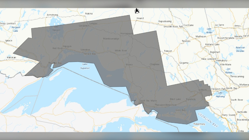 Weather alert map showing special weather statements (grey) in northeastern Ontario as of 5:15 p.m. on April 28, 2024. (Supplied/Environment Canada)
In statements on Sunday , weather forecasters said significant freezing rain or heavy rain is possible into Monday.
Freezing rain
As of 1 p.m., the special weather statement regarding freezing rain were in effect for the communities of Agawa, Beardmore, Black Sturgeon Lake, Caramat, Chapleau, Geraldton, Gull Bay, Hornepayne, Jellicoe, Lake Superior Park, Longlac, Macdiarmid, Manitouwadge, Marathon, Missinaibi Lake, Nipigon, Pukaskwa, Raith, Superior North, Superior West, Thunder Bay, Upsala, Wawa and White River.
“A low pressure system is expected to affect the region and a period of freezing rain and ice pellets is possible,” read the updated statement.
"For most areas freezing rain will be brief before changing to rain or snow, however areas of higher terrain may see freezing rain last slightly longer."
Hazards include ice build-up and icy surfaces due to freezing rain.
Forecasters said that power outages are possible during the weather event and the freezing rain may result in surfaces such as highways, roads, walkways and parking lots becoming slippery.
 An undated file photo of ice formed from freezing rain. (CTV News)
Heavy rain
As of shortly before 1:30 p.m., special weather statements were issued in the communities of Greater Sudbury and area, Manitoulin Island Sault Ste. Marie, Batchawana Bay, Blind River, Elliot Lake, Killarney, Montreal River Harbour, Ranger Lake, Searchmont and St. Joseph Island for heavy rainfall with 20 – 30mm of rain expected from Sunday evening into Monday afternoon or evening.
“A low pressure system will bring another round of rain to the area,”read the statements.
“The ground, already near saturation, has little ability to absorb further rainfall.”
Forecasters said localized flooding in low-lying areas is possible.
 Several communities in northeastern Ontario are under weather alerts for heavy rain. (File photo/CTV News)
To report severe weather, send an email to ONstorm@ec.gc.ca or tweet reports using #ONStorm.
Original story:
Environment Canada issued a severe thunderstorm watch for several communities in northeastern Ontario on Saturday afternoon – primarily the Greater Sudbury area and West Nipissing.
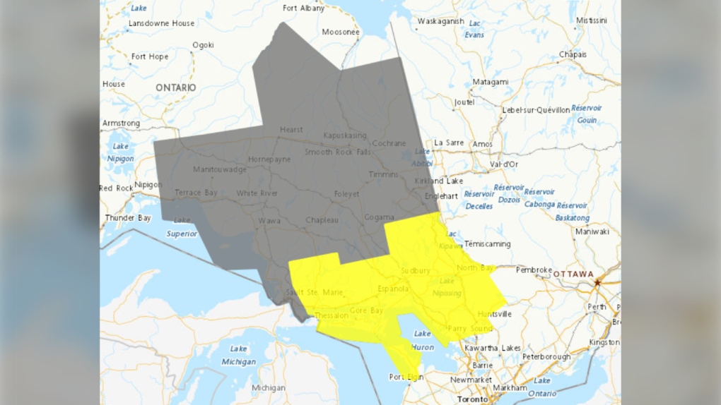 Weather alert map (yellow -- thunderstorm watch and grey -- rainfall weather statement) as of 4:15 p.m. on April 27, 2024. (Supplied/Environment Canada)
The watch includes areas of North Bay, Parry Sound, West Nipissing and Greater Sudbury and vicinity along with the communities of Bayfield Inlet, Blind River, Bruce Peninsula, Burk's Falls, Chapleau, Dunchurch, Elliot Lake, Espanola, French River, Killarney, Manitoulin Island, Mattawa, Missinaibi Lake, Muskoka, North Bay, Powassan, Ranger Lake, Sauble Beach, South River, Temagami, Temiskaming Shores, Thessalon and Tobermory.
This comes as most of the region was already under a special weather statement for rainfall of up to 45mm and flood watches are in effect for most areas affected.
“Conditions are favourable for the development of severe thunderstorms that may be capable of producing large hail and heavy rain,” Environment Canada said in its statements.
Hazards include rapid rainfall of up to 50mm in an hour, twoonie size hail, and flash flooding late Saturday afternoon into the night.
“Large hail can damage property and cause injury,” the statement said.
“Heavy downpours can cause flash floods and water pooling on roads.”
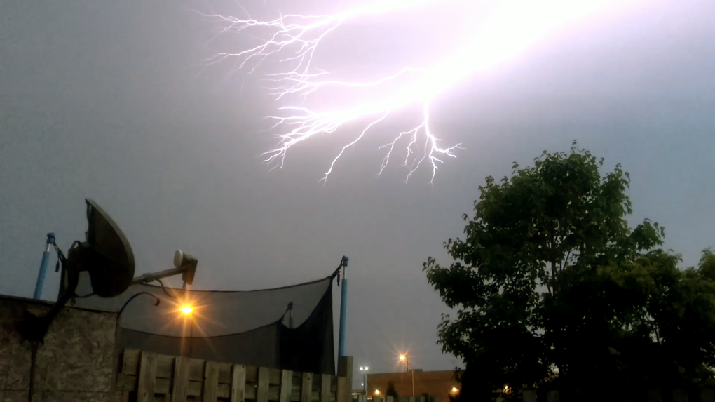 Lightning strikes a North Bay, Ont., sky on June 11, 2017. (File photo/Supplied/Cody Holliday)
Severe thunderstorm watches are issued when atmospheric conditions are favourable for the development of thunderstorms.
“(Storms) could produce one or more of the following: large hail, damaging winds, torrential rainfall,” read the statement.
Emergency Management Ontario recommends that you take cover immediately if threatening weather approaches, said Environment Canada officials.
For more information on how to prepare for an emergency, visit their website.
To report severe weather, send an email to ONstorm@ec.gc.ca or tweet reports using #ONStorm.


CTVNews.ca Top Stories

BREAKING
BREAKING Another suspect arrested in Toronto Pearson airport gold heist: police
Another suspect is in custody in connection with the gold heist at Toronto Pearson International Airport last year, police say.
BREAKING
BREAKING Justin and Hailey Bieber are expecting their first child together
Hailey and Justin Bieber are going to be parents. The couple announced the news on Thursday on Instagram, both sharing a video that showcases Hailey Bieber's growing belly.
From outer space? Sask. farmers baffled after discovering strange wreckage in field
A family of fifth generation farmers from Ituna, Sask. are trying to find answers after discovering several strange objects lying on their land.
Poilievre-led government 'would never' use notwithstanding clause on abortion, his office says
A Conservative government led by Pierre Poilievre would not legislate on, nor use the notwithstanding clause, on abortion, his office says, as anti-abortion protesters gather on Parliament Hill.
Ontario family receives massive hospital bill as part of LTC law, refuses to pay
A southwestern Ontario woman has received an $8,400 bill from a hospital in Windsor, Ont., after she refused to put her mother in a nursing home she hated -- and she says she has no intention of paying it.
Here are the ultraprocessed foods you most need to avoid, according to a 30-year study
Studies have shown that ultraprocessed foods can have a detrimental impact on health. But 30 years of research show they don’t all have the same impact.
Miss Teen USA steps down just days after Miss USA's resignation
Miss Teen USA resigned Wednesday, sending further shock waves through the pageant community just days after Miss USA said she would relinquish her crown.
Why these immigrants to Canada say they're thinking about leaving, or have already moved on
For some immigrants, their dreams of permanently settling in Canada have taken an unexpected twist.
Cyclist strikes child crossing the street to catch school bus in Montreal
A video circulating on social media of a young girl being hit by a bike has some calling for better safety and more caution when designing bike lanes in the city. The video shows a four-year-old girl crossing Jeanne-Mance Street in Montreal's Plateau neighbourhood to get on a school bus stopped on the opposite side of the street
Shopping Trends
The Shopping Trends team is independent of the journalists at CTV News. We may earn a commission when you use our links to shop. Read about us.


Barrie
-

Barrie man who feigned cancer to draw sympathy from victims pleads guilty to sex crimes
A Barrie man convicted of sexually assaulting teenage girls over a decade ago while pretending to have cancer to draw sympathy from his victims pleaded guilty on Thursday, again to sexual assault.
-
Man accused in Elnaz Hajtamiri murder case charged with assaulting inmate
Mohamad Lilo, the 36-year-old Montreal-area man, accused in the murder and kidnapping of his former girlfriend, Elnaz Hajtamiri, has now been charged with assaulting an inmate at Central North Correctional Centre.
-
Proposed waterfront development gets thumbs up from city councillors
Barrie city councillors granted preliminary approval to a proposed waterfront development intended to accommodate the Sea Cadets and provide benefits for sports organizations, sparking mixed reactions.
Toronto
-
BREAKING
BREAKING Another suspect arrested in Toronto Pearson airport gold heist: police
Another suspect is in custody in connection with the gold heist at Toronto Pearson International Airport last year, police say.
-
Dessert shop in Ajax featured by Keith Lee forced to move after zoning complaint
A small Ajax dessert shop that recently received a glowing review from celebrity food critic Keith Lee is being forced to move after a zoning complaint was made following the social media influencer’s visit last month.
-
Sheldon Keefe out as head coach of Toronto Maple Leafs
The Toronto Maple Leafs have fired head coach Sheldon Keefe. The team made the announcement Thursday after the Original Six franchise lost to the Boston Bruins in seven games in the first round of the Stanley Cup playoffs.
Ottawa
-

6 injured in Sharbot Lake, Ont. crash; 2 in life-threatening condition
Ontario Provincial Police say six people have suffered severe injuries in a single-vehicle crash in Sharbot Lake, Ont, including two in life-threatening condition.
-
Ottawa police looking to identify suspect involved with assault in Chinatown
The Ottawa Police Service is asking the public for help in identifying a suspect involved with an assault that happened in Chinatown earlier this month.
-
This Ottawa ward has the most complaints about rats so far in 2024
Bylaw and Regulatory Services received 119 service requests for rats on private property so far in 2024, after receiving 779 service requests in 2023.
Kitchener
-

Wilfrid Laurier football player drafted despite only playing 27 games in his entire life
A Listowel, Ont. man, drafted by the Hamilton Tigercats last week, is also getting looks from the NFL, despite only playing 27 games of football in his life.
-
Long-time CKCO personality, Janine Grespan, dies at 63
A broadcaster familiar to many CTV News watchers has died at the age of 63.
-
BREAKING
BREAKING Another suspect arrested in Toronto Pearson airport gold heist: police
Another suspect is in custody in connection with the gold heist at Toronto Pearson International Airport last year, police say.
London
-

Josh Morgan announces separation from his wife
London Mayor Josh Morgan has announced the separation between him and his wife Melanie.
-
OPP searching for three masked suspects after stabbing in Norwich
One person suffered non life-threatening injuries following a stabbing Wednesday night in Norwich.
-
BREAKING
BREAKING Justin and Hailey Bieber are expecting their first child together
Hailey and Justin Bieber are going to be parents. The couple announced the news on Thursday on Instagram, both sharing a video that showcases Hailey Bieber's growing belly.
Windsor
-

51-year-old Wheatley man dies in Merlin crash
Chatham-Kent police say a 51-year-old Wheatley man has died after a single vehicle collision south of Merlin, Ont.
-
Four Windsor-Essex men arrested in underage prostitution operation
Windsor police and OPP say they have arrested four men during an undercover operation targeting men seeking sex with underage girls.
-
Ontario family receives massive hospital bill as part of LTC law, refuses to pay
A southwestern Ontario woman has received an $8,400 bill from a hospital in Windsor, Ont., after she refused to put her mother in a nursing home she hated -- and she says she has no intention of paying it.
Montreal
-

Man pleads guilty in Montreal hit-and-run that killed 7-year-old Ukrainian refugee
A Quebec man has pleaded guilty to a fatal hit-and-run in Montreal that killed seven-year-old Mariia Legenkovska, a Ukrainian refugee who had just fled the Russian invasion in Ukraine.
-
Cyclist strikes child crossing the street to catch school bus in Montreal
A video circulating on social media of a young girl being hit by a bike has some calling for better safety and more caution when designing bike lanes in the city. The video shows a four-year-old girl crossing Jeanne-Mance Street in Montreal's Plateau neighbourhood to get on a school bus stopped on the opposite side of the street
-
Man fatally struck while changing tire on Highway 15 north of Montreal
One man is dead north of Montreal after he was struck by a truck while changing a tire on Highway 15.
Winnipeg
-

Winnipeg trial hears victims' clothing, jewelry found in serial killer's apartment
The trial of serial killer Jeremy Skibicki heard Thursday that police found physical evidence of the victims in his apartment, including jewelry, clothing, DNA and a blood-stained bathtub.
-
Last-ditch effort to keep St. Boniface pool open voted down by city committee
A last-ditch effort to keep a St. Boniface pool open for another year may have gone down the drain for good.
-
Winnipeg wants your opinion on the future of Graham Avenue
The City of Winnipeg is looking for public feedback on a new vision for Graham Avenue that will see it become a multi-use corridor focused on pedestrians and activities.
Atlantic
-

'Nobody should be getting away with murder': Grieving mother speaks out after son killed in North Preston, N.S.
A grieving mother is speaking out after her 36-year-old son was shot and killed in North Preston, N.S., Wednesday night.
-
Impaired driver allegedly crashed into N.S. RCMP detachment
A Nova Scotia RCMP detachment was damaged after an impaired driver allegedly crashed into the building in Waycobah early Thursday morning.
-
Whooping cough outbreak declared in eastern Newfoundland
Health officials say there is an outbreak of whooping cough in eastern Newfoundland.
N.L.
-

Trucker's body found in trailer in Newfoundland after failed police search in Ontario
Ontario Provincial Police are facing tough questions about their search for a missing Newfoundland trucker whose rig was found two weeks ago in Ontario, then sent back to Newfoundland, where his body was found Monday in the trailer.
-
Crown, defence present closing arguments for N.L. lawyer accused of sexual assault
The trial of a Newfoundland lawyer accused of sexual assault ended Tuesday with his defence team alleging the complainant lied under oath, while the prosecution said her memory lapses were understandable.
-
Newfoundland and Labrador latest province to tighten rules on Airbnbs
Newfoundland and Labrador is the latest jurisdiction to bring in stricter rules for short-term rentals, with a coming set of regulations that will force operators to register with the provincial government.
Calgary
-

Calgary police release sketch of man found dead near Bow River
Calgary police have released the composite sketch of a man found dead near the Bow River in March in hopes it will assist the public in identifying him.
-
Calgary Transit sets new record for monthly riders, hitting 8.79M in March
Calgary Transit set a new one-month ridership record in March, when close to eight million boardings were recorded, the city said in a media release Thursday.
-
Firebirds outgun the Wranglers 7-5 in AHL playoff barn burner
A third period double-minor penalty proved to be the Calgary Wranglers’ undoing Wednesday night as they lost to the Coachella Valley Firebirds 7-5 in Game 3 of their best-of-five AHL playoff series.
Edmonton
-

Zach Hyman gifts signed Oilers jersey to 'Shaq Hyman'
Edmonton Oilers forward Zach Hyman gifted a signed #18 jersey to NBA legend Shaquille O'Neal.
-
2024 pool season: Queen Elizabeth to open by long weekend, Mill Creek to open for first time in 4 years
Two of Edmonton's outdoor pools are scheduled to be open by the end of the month and the season will also see the reopening of the renovated Mill Creek Outdoor Pool.
-
Grande Prairie region under fire ban heading into expected dry, windy weekend
A fire ban has been reinstated in the Grande Prairie Forest Area, where the fire risk is highest in Alberta as temperatures climb.
Regina
-

From outer space? Sask. farmers baffled after discovering strange wreckage in field
A family of fifth generation farmers from Ituna, Sask. are trying to find answers after discovering several strange objects lying on their land.
-
Drug use relapse on Sask. First Nation result of family doctor loss, NDP say
The Saskatchewan NDP say 1,000 residents of Beardy's and Okemasis Cree Nation north of Saskatoon have been without a family doctor since 2023, highlighting the state of rural healthcare in the province.
-
'Somebody knows what happened': Sask. father searches for answers in son's disappearance
The father of a 28-year-old Onion Lake Cree Nation man is calling for anyone with information about his son, to contact police.
Saskatoon
-

'Hours, not days': Concerns grow around accuracy of THC roadside testing in Sask.
Concern is growing around roadside THC testing, cannabis use and driving in Saskatchewan.
-
'Somebody knows what happened': Sask. father searches for answers in son's disappearance
The father of a 28-year-old Onion Lake Cree Nation man is calling for anyone with information about his son, to contact police.
-
Drug use relapse on Sask. First Nation result of family doctor loss, NDP say
The Saskatchewan NDP say 1,000 residents of Beardy's and Okemasis Cree Nation north of Saskatoon have been without a family doctor since 2023, highlighting the state of rural healthcare in the province.
Vancouver
-

B.C. wildfires likely to spread with weekend temperatures expected to soar, province says
Wildfire and emergency management officials in British Columbia are urging residents to be prepared for increased fire activity as temperatures are expected to soar above 30 C in parts of the province this weekend.
-
Police searching for driver after cyclist seriously injured in hit-and-run crash near Victoria
Mounties on Vancouver Island are searching for the driver of a Jeep Wrangler after a cyclist suffered serious injuries in an alleged hit-and-run collision near Victoria early Thursday morning.
-
Rivers recede as B.C. faces prospect of 'unfamiliar territory' for drought
Parts of British Columbia will likely enter "unfamiliar territory" with drought if they see another hot, dry summer, says the head of the province's River Forecast Centre.
Vancouver Island
-

Police searching for driver after cyclist seriously injured in hit-and-run crash near Victoria
Mounties on Vancouver Island are searching for the driver of a Jeep Wrangler after a cyclist suffered serious injuries in an alleged hit-and-run collision near Victoria early Thursday morning.
-
B.C. wildfires likely to spread with weekend temperatures expected to soar, province says
Wildfire and emergency management officials in British Columbia are urging residents to be prepared for increased fire activity as temperatures are expected to soar above 30 C in parts of the province this weekend.
-
Galápagos Islands mail mystery solved after phone call from stranger
When Sherry Kirkvold played the voicemail message from a stranger – which began with, “Hi. This is kind of a random message for you. This one’s been a while.” – she couldn’t have been more surprised.


