Incoming snowstorm expected to bring up to 15 cm, many school buses cancelled
Environment Canada issued weather alerts across northeastern Ontario on Thursday morning as an approaching storm is expected to bring up to 15 cm of snow.
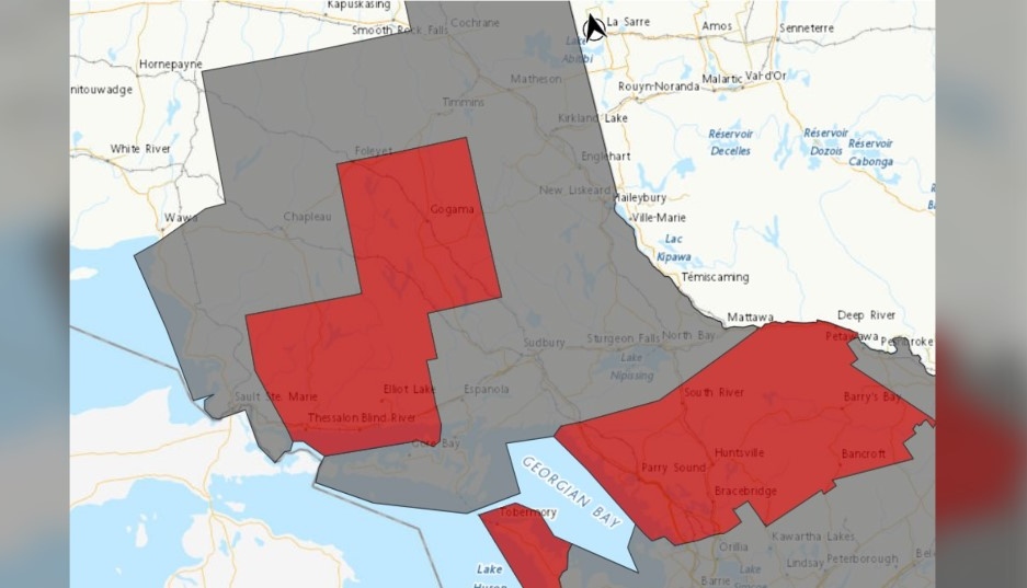 Environment Canada weather alert map for 2.15.24 (Grey - winter weather travel advisory. Red-snowfall warning)
Many school bus routes have been cancelled as a result of the weather.
Check the list of school bus cancellations here.
Winter weather travel advisories and snowfall warnings are in effect.
GREATER SUDBURY - MANITOULIN ISLAND
"Snow, at times heavy, will begin this morning and continue through the day before tapering off early this evening," Environment Canada said Thursday morning.
"Northwest winds gusting to 60 km/h may result in localized blowing snow this afternoon and tonight, especially in exposed areas."
While the Greater Sudbury area is under a winter weather travel advisory, snowfall is expected to be more intense north of the city from Gogama to Foleyet, which are under a snowfall warning.
NORTH BAY TO COCHRANE
Winter weather travel advisories are in effect from Massey east to Mattawa along Highway 17 and from North Bay north to Cochrane along Highway 11.
"Snow, at times heavy, will begin late this morning and continue tonight before tapering off by Friday morning," Environment Canada said Thursday.
"Northwest winds gusting to 50 km/h tonight may result in localized blowing snow in exposed areas."
Slick roads and reduced visibility are expected to make travel hazardous in these areas.
NORTH SHORE AREA
Snowfall warnings are in effect for North Shore communities along Highway 17 from Thessalon to Massey and include Elliot Lake.
"Snow, at times heavy, will begin this morning and continue through the day before tapering off late this afternoon or this evening," Environment Canada said Thursday morning.
"As the snow tapers off, northwest winds gusting up to 60 km/h may result in localized blowing snow this afternoon and tonight."
Peak snowfall rates of two-four cm/h is expected.
SAULT STE. MARIE AREA
"Snow, at times heavy, will continue into this afternoon giving snowfall accumulations of up to 10 cm. Northwest winds gusting up to 60 km/h will develop near noon leading to localized blowing snow this afternoon and evening," Environment Canada said.
"A break in the snowfall is possible late this afternoon before lake effect flurries develop early this evening giving additional snowfall accumulations of up to 5 cm before tapering off near midnight."
SNOWBELT
For anyone needing to travel through the Parry Sound area, snowfall warnings are in effect.
"An area of heavy snow will push through the region during the afternoon and early evening hours today," Environment Canada said Thursday morning.
"The majority of snowfall accumulations may fall within just a few hours due to high snowfall rates. Heavy snow will taper to light flurries through the evening"
Peak snowfall rates of three-five cm/h are expected east of Georgian Bay.
Shopping Trends
The Shopping Trends team is independent of the journalists at CTV News. We may earn a commission when you use our links to shop. Read about us.


CTVNews.ca Top Stories

Trudeau talks border, trade in surprise dinner with Trump at Mar-a-Lago
Prime Minister Justin Trudeau discussed border security and trade during a surprise dinner with U.S.-president elect Donald Trump at Mar-a-Lago in West Palm Beach, Fla. on Friday evening, according to senior government sources.
Man who died trying to help stranded motorist identified as Khalid Farooq, father of 5
The man who lost his life trying to help a stranded motorist Wednesday has been identified as Khalid Farooq.
W5 Investigates
W5 Investigates 'I never took part in beheadings': Canadian ISIS sniper has warning about future of terror group
An admitted Canadian ISIS sniper held in one of northeast Syria’s highest-security prisons has issued a stark warning about the potential resurgence of the terror group.
Are scented candles bad for you? What the science says
Concerns about the safety of candles are rooted in the chemical reactions that occur when you burn them, as well as in the artificial fragrances and colorants that contribute to the various scents you may love.
Poilievre suggests Trudeau is too weak to engage with Trump, Ford won't go there
While federal Conservative Leader Pierre Poilievre has taken aim at Prime Minister Justin Trudeau this week, calling him too 'weak' to engage with U.S. president-elect Donald Trump, Ontario Premier Doug Ford declined to echo the characterization in an exclusive Canadian broadcast interview set to air this Sunday on CTV's Question Period.
Emboldened 'manosphere' accelerates threats and demeaning language toward women after U.S. election
An emboldened “manosphere” has seized on Republican Donald Trump ’s presidential win to justify misogynistic derision and threats online.
Montreal researchers make breakthrough discovery in fighting HIV
Researchers in Montreal have made a breakthrough discovery in HIV research by finding a way to expel the virus from its hiding places and destroy it.
Cucumbers sold in Ontario, other provinces recalled over possible salmonella contamination
A U.S. company is recalling cucumbers sold in Ontario and other Canadian provinces due to possible salmonella contamination.
Great Lakes, Plains and Midwest forecast to be hit with snow and dangerous cold into next week
The first big snow of the season threatened to bury towns in New York along lakes Erie and Ontario during a hectic holiday travel and shopping weekend, while winter storm conditions could persist into next week and cause hazards in the Great Lakes, Plains and Midwest regions.
Barrie
-

OPP search for missing woman
Police are searching for a missing woman who was last seen in Orillia Friday morning.
-
Structure fire in Tottenham
Emergency crews are responding to a reported structure fire in Tottenham.
-
Man airlifted with critical injuries after Haliburton crash
One person was airlifted to a trauma centre with serious injuries after a collision in Haliburton on Friday.
Toronto
-

Why this Toronto man ran so a giant stickman could dance
Colleagues would ask Duncan McCabe if he was training for a marathon, but, really, the 32-year-old accountant was committing multiple hours of his week, for 10 months, to stylistically run on the same few streets in Toronto's west end with absolutely no race in mind. It was all for the sake of creating a seconds-long animation of a dancing stickman for Strava.
-
'A huge, huge hit:' Ontario would be disproportionately impacted by Trump’s proposed tariffs, expert says
If U.S. President-elect Donald Trump follows through on a threat to impose a 25 per cent tariff on all Canadian imports, Ontario will likely see the brunt of the impact, a business professor at Carleton University says.
-
Driver injured following Mississauga collision: PRP
The driver in a single vehicle collision has been taken to hospital with serious injuries after a collision in Mississauga Saturday morning.
Ottawa
-

It's time for a good movie this holiday season, here's what's new in theatres
This holiday season has a special edition at the theatres with movies "that everyone has been waiting for," says a movie expert from Ottawa.
-
New plan in the making to free cargo ship stuck in St. Lawrence River near Morrisburg, Ont.
A new plan to free the Tim S. Dool, a large cargo ship that ran aground on a shoal along the St. Lawrence River near Morrisburg, Ont. on Saturday is expected to be finalized early next week.
-
Canadian Army vehicles on roads and highways in the Ottawa area starting this weekend
Attention eastern Ontario drivers! You may see an increased number of Canadian Army vehicles on roads and highways in the Ottawa area starting this weekend, warns the Ontario Provincial Police (OPP).
Kitchener
-

Traffic chaos on Highway 401 through Kitchener
Highway 401, through Kitchener, was brought to a standstill Friday due to an investigation by Ontario Provincial Police.
-
Family of Guelph, Ont. man killed in B.C. crash pushing for case review
The family of a Guelph, Ont. man who was killed in a car crash in British Columbia is pushing for a review of the case, after learning about the charge that a driver involved is now facing.
-
Region of Waterloo considers reducing, and even cutting, some services to keep tax increase down
The Region of Waterloo is considering reducing or eliminating some services in an effort to lower the potential 2025 tax increase.
London
-

Collision closes Wellington Road northbound
A two vehicle collision had crews on the scene this morning in the south end of the city.
-
London considers opening up more land for residential development in city’s rural areas
In the midst of a housing crisis, city council will consider expanding the areas where residential development is permitted by adjusting a boundary line in place to stop urban sprawl.
-
Parts of region bracing for up to one metre of snow this weekend
It’s a day for digging in Bruce County. School buses across Bruce and Grey counties were cancelled Friday due to snowsqualls that dumped as much as 15 centimetres of snow on the region overnight.
Windsor
-

Firearms offender arrested in Windsor after violating conditions of release
Just a month after being released from jail on firearm related charges, a Windsor man has been arrested once more.
-
CTV News Windsor’s top stories from this week
In case you missed it, CTV News Windsor has compiled all of the top local stories from this week into one video.
-
Windsor MP expresses relief nuclear waste site will go north to Ignace
A planned nuclear waste storage facility won’t be coming to southern Ontario and that is reason to rejoice for Brian Masse, the Windsor West MP and NDP Great Lakes critic.
Montreal
-

Buying a home? Here's everything you need to know about Quebec's 'welcome' tax
Anyone who has bought a home in Quebec knows the rollercoaster high of making that big, life-changing purchase – and the sudden crash that occurs when the welcome tax bill comes in the mail, alongside its 30-day payment deadline.
-
Montreal researchers make breakthrough discovery in fighting HIV
Researchers in Montreal have made a breakthrough discovery in HIV research by finding a way to expel the virus from its hiding places and destroy it.
-
SPVM investigating stabbing at homeless encampment in Southwest borough
Montreal police (SPVM) are investigating after a 44-year-old man was stabbed late on Friday in the city’s Southwest borough.
Winnipeg
-

True North officially buys Portage Place Mall
True North Real Estate Development (TNRED) has officially purchased Portage Place Mall.
-
Parts of southwestern Manitoba under extreme cold warning, temperatures could feel like -40
Much of southwestern Manitoba is under an extreme cold warning as the wind chill could make temperatures feel close to minus 40.
-
'Very alarming:' Online scams spike during the holidays
Shoppers are out looking for the best deals on gifts for their loved ones. However, the RCMP and the Better Business Bureau are warning people that the deals they’re seeing online might be too good to be true.
Atlantic
-

Man charged after Halifax high school placed in hold and secure
A man has been charged after a high school in Halifax was placed in hold and secure Friday morning.
-
Teen arrested in connection with weapons call at Fredericton High School
Fredericton Police Force arrested a 14-year-old boy Thursday in relation to a weapons call at Fredericton High School.
-
New book puts the lens on historic N.S. filmmaker Margaret Perry
A Nova Scotia artist known as one of Canada’s most prolific early filmmakers is having the focus put on her story.
N.L.
-

Newfoundland's LGBTQ2S+ bar paid drag queens $37.50. Tara Nova called them out.
If the screaming crowd in the twinkling Majestic Theatre in downtown St. John's was any indication, Newfoundland drag queen Tara Nova will never have to accept $37.50 for a show again.
-
'Who profits on hunger?': Inuit send pleading emails to minister about food costs
People in Nunavut and northern Labrador have been writing to Canadian government officials this year to say grocers were charging exorbitant prices despite receiving a federal subsidy.
-
As N.L. firm pivots, scientists say Canada's green hydrogen dreams are far-fetched
A Newfoundland energy company's embrace of data centres is raising doubts about eastern Canadian hopes of harnessing the region's howling winds to supply Germany with power from green hydrogen.
Calgary
-

Man who died trying to help stranded motorist identified as Khalid Farooq, father of 5
The man who lost his life trying to help a stranded motorist Wednesday has been identified as Khalid Farooq.
-
Cautious optimism? Alberta energy sector prepping for a turbulent 2025
Energy sector leaders say they're happy with how 2024 went but fear the stretch of good fortune could end in 2025.
-
1 person in serious condition following southeast Calgary stabbing, suspect in police custody
A man was seriously injured in a stabbing incident in southeast Calgary on Friday.
Edmonton
-
Ryan Nugent-Hopkins scores in OT to lift Oilers to 4-3 win over Utah
Ryan Nugent-Hopkins scored 1:18 into overtime and the Edmonton Oilers beat the Utah Hockey Club 4-3 on Friday night.
-
Massage therapist charged in connection with sexual assault at Mill Woods clinic
An Edmonton massage therapist has been charged with sexual assault in connection with an incident earlier this year.
-
Lights, markets and parades: Here's what's happening in and around Edmonton this weekend
The holiday magic never stops in Edmonton and the city, and surrounding communities, has plenty happening to keep people busy this weekend.
Regina
-

Regina's LED volume wall leaving Sask. months after opening
Less than a year after an LED volume wall was introduced to the film world in Saskatchewan, the equipment is making its exit from the province.
-
Sask. NDP says Scott Moe, staff stayed in Toronto hotel at rate over $800 per night
The Saskatchewan NDP says Premier Scott Moe and three Saskatchewan Party staff members stayed at a hotel in Toronto last June that cost each of them $818.74 per night for a three-night stay.
-
Jury sequestered to find verdict in sexual assault trial against Regina chiropractor
Justice Janet McMurtry sequestered a 12-person jury to determine a verdict against Regina-based chiropractor Ruben Manz.
Saskatoon
-

Saskatoon priest accused of sexual assault says he meant to encourage young girl with hug and kiss
A Saskatoon priest accused of sexual assault says he meant to encourage and reassure a young girl when he hugged and kissed during his testimony at Saskatoon Provincial Court Friday.
-
Saskatoon temporary smudge location to be taken down
While the City of Saskatoon says it granted a temporary permit for smudging and a ceremonial open fire, that expired at 6p.m. Tuesday night.
-
'A huge value addition': Sask. scientists develop way to make canola meal more profitable
Researchers at the University of Saskatchewan are looking at making the canola crop more profitable.
Vancouver
-

Students push for AEDs at Vancouver schools following friend's death
Following the tragic death of their friend, a group of students is pushing for automated external defibrillators, or AEDs, to be installed in all Vancouver schools.
-
Health authority apologizes after hospital sends blind senior to Downtown Eastside shelter
The Fraser Health authority has issued an apology after 86-year-old Gwendalyn Deraspe was released on Tuesday from Ridge Meadows hospital and sent in a cab by staff to live at a Downtown Eastside women’s shelter.
-
Calgary man claims B.C. trucking company compromised his safety
A Calgary man says a B.C. trucking company did not not listen to his safety concerns during a recent shift.
Vancouver Island
-

Yuletide festivities help kick off holiday season in Greater Victoria
Greater Victoria has a host of yuletide festivities this weekend for residents ready to kick off the holiday season.
-
Supreme Court clears way for B.C. to include other governments in opioid lawsuit
B.C. Attorney General Niki Sharma says a Supreme Court of Canada victory has cleared a "pathway" for governments across the country to go after opioid makers and distributors for damages arising from the opioid crisis.
-
Study of 2023 Okanagan wildfires recommends limiting development in high-risk areas
A study into the devastating wildfires that struck British Columbia's Okanagan region in 2023 has recommended that government and industry limit development in high-fire-risk areas.


