Extreme forest fire hazards in parts of the northeast, 2 fires not under control
As of Sunday evening, there were 20 active wildfires in northeastern Ontario. Two fires are not yet under control, two fires are being held and 16 are being observed.
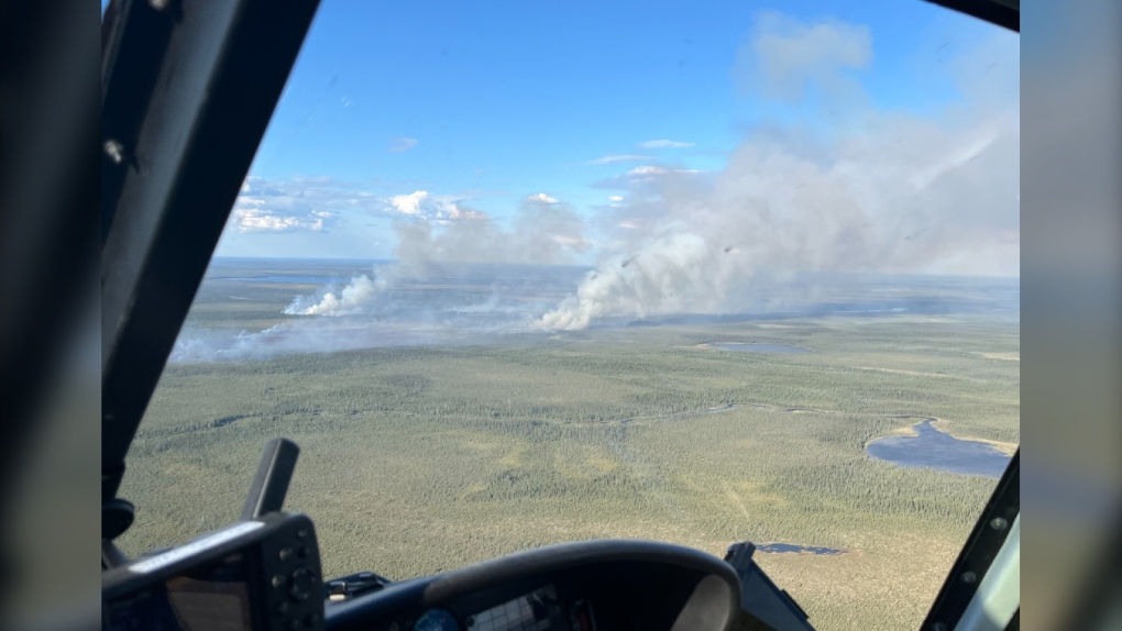 An aerial view of Cochrane 9 taken June 2, 2024, from a helicopter. (Ministry of Natural Resources & Forestry/X | Photo Credit: Chad Porter/Cochrane Fire Management Headquarters)
The largest fire which is not under control is Hearst 8. The fire measured 84 hectares as of Sunday evening and is located northern region of Nagagamisis Provincial Park approximately 35 kilometers northwest of the community of Constance Lake.
"Four crews of fire rangers are dedicated to this fire and are currently receiving air attack support from 2 CL-415 waterbombers guided by an air attack officer in a birddog aircraft," said Ministry of Natural Resources & Forestry (MNRF) officials in an update Sunday evening.
All 16 fires in the Cochrane district are being observed – with Cochrane 9 burning since June 2 and now measuring more than 6,000 hectares.
“Cochrane 9, is now being observed,” said said the ministry’s Aviation, Forest Fire and Emergency Services (AFFES) officials on social media earlier this season.
“Initially very active, it has seen many bouts of significant rain. This Far North fire is now being monitored to allow the natural ecological benefits of fire on the landscape.”
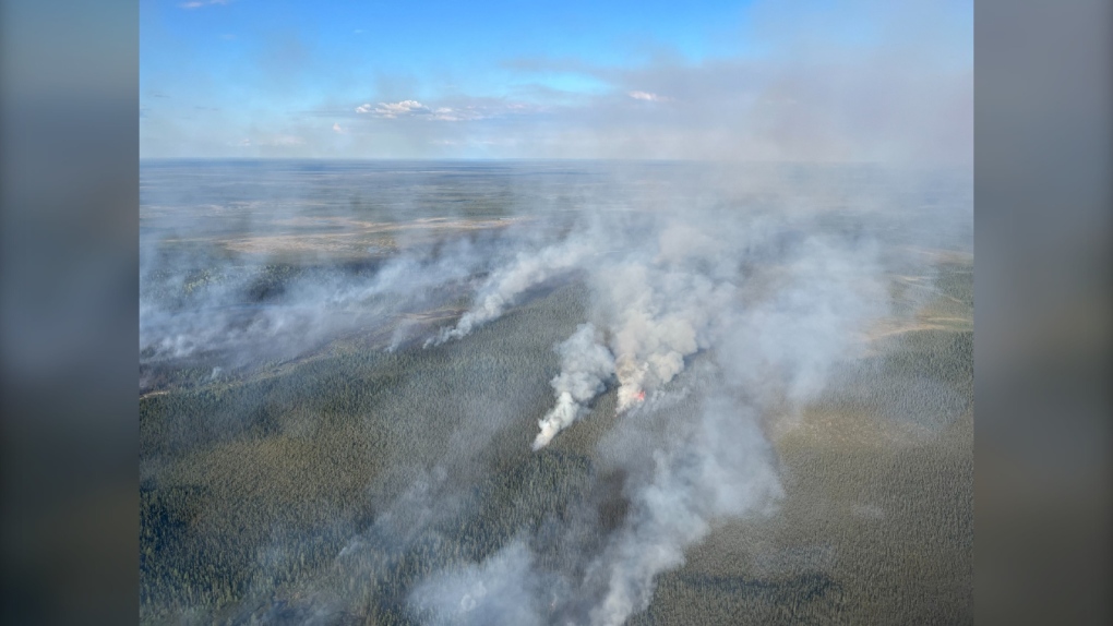 Aerial view of Cochrane 9 in early June 2024. (Ministry of Natural Resources & Forestry/X | Photo Credit: Chad Porter/Cochrane Fire Management Headquarters)
Sudbury 19 was confirmed late Saturday and located near Green Bay on the western shore of Onaping Lake. This firest is now out.
Details of the other three active fires in the region can be found here:
- Sault Ste. Marie 9 (SAU009) is a 1-hectare fire that is being held and is located on the northern shore of Duval Lake.
- Wawa 10 (WAW010) is a 0.1-hectare fire that is being held and is located approximately nine kilometers north of Dotted Lake.
- Kirkland Lake 5 (KLk005) is a 55-hectare fire that was confirmed Saturday and is not yet under control. Aerial suppression was carried out on Aug. 3 and fire ranger crews remain on site. The fire is located 5.5 kilometers southeast of McKee Lake.
The fire hazard remains moderate to high across most of the northeast fire region, according to AFFES.
“There are pockets of extreme fire hazard over Pukaskwa National Park, east of Obatanga Provincial Park, north of Elliot Lake and an area north of Kapuskasing over the Mattagami River,” said the ministry in its update Sunday evening.
The hazard level for Capreol, Temiskaming Shores, Longpoint Lake on Highway 560 and northeast of Timmins remains high.
Northwestern Ontario update
As of Sunday evening, there are 38 active fires in the Northwest Region in various stages of control with four new wildfires confirmed on Aug. 4.
“Four are under control, two are being held, eight are not under control and the remainder are being observed.,” read the ministry’s website on Sunday morning.
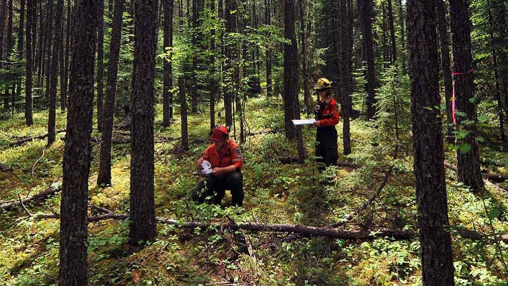 An undated photo of Aviation, Forest Fire and Emergency Services personnel measuring water in small plastic cups in the boreal forest. (Ministry of Natural Resources & Forestry/X)
Interactive fire map
The MNRF’s interactive map visually shows active fires, current fire danger across Ontario and any restricted fire zones in effect with real-time updates as information becomes available.
The map can be viewed here.
Stay clear of waterbombers
AFFES is asking the public that when waterbombers approach a body of water to move close to the shore so they can perform their scoop safely as a waterbomber will not scoop from a lake or river if encroaching watercraft pose a safety hazard.
 An undated photo of a yellow waterbomber dropping water over a forested area. (Ministry of Natural Resources & Forestry/X)
“Waterbombers scoop and drop water onto a fire in a repetitive pattern,” the ministry said on social media Saturday.
“If you see a waterbomber scooping from a lake or river, they are likely to return several times. Move to the shore and give them ample room to work safely.”
Forest fires are no drone zones
The ministry is reminding people that flying drones around forest fires is both dangerous and illegal.
“When you fly a drone near a forest fire, you can put the lives of pilots, firefighters and other emergency personnel at risk,” said the AFFES update Saturday.
It is illegal to fly drones (also known as UAVs or RPAS) within nine kilometres of any active wildland fire.
Reporting a wildland fire
To report a wildland fire located north of the French and Mattawa rivers, please dial 310-FIRE. To report a wildland fire located south of the French or Mattawa Rivers, please dial 911.
Top Stories
-
-
-
-
-
 VIDEO
VIDEOVIDEO Snow has returned to northeastern Ont.
-
-
-


CTVNews.ca Top Stories

Air Canada begins preparations for shutdown due to 'inflexible' union demands
Air Canada is finalizing plans to suspend most of its operations, likely beginning Sunday, as talks with the pilot union are nearing an impasse over 'inflexible' wage demands, the country's largest airline said on Monday.
Former fashion tycoon Peter Nygard's long-delayed sentencing expected today
Former fashion mogul Peter Nygard is expected to be sentenced for his sexual assault convictions today, after multiple delays in the case that have stretched for months.
WATCH LIVE
WATCH LIVE PWHL unveils team nicknames and logos entering women's hockey league's second season
In a process nearly a year in the making, the Professional Women’s Hockey League on Monday unveiled the nicknames and logos for each of its six franchises entering its second season.
Justin Trudeau may be in for an earful as he meets with caucus in B.C.
Prime Minister Justin Trudeau may be bracing for an earful from his caucus when Liberal MPs gather in Nanaimo, B.C. today to plot their strategy for the coming election year.
Trial begins over Texas 'Trump Train' highway confrontation
A federal trial is set to begin Monday over claims that supporters of former U.S. president Donald Trump threatened and harassed a Biden-Harris campaign bus in Texas four years ago, disrupting the campaign on the last day of early voting.
Hunt widens for man who allegedly threw scalding coffee on baby
A man wanted for allegedly throwing scalding coffee on a baby in an unprovoked attack at a park in the northern Australian state of Queensland is now the subject of an international manhunt.
A golden eagle has attacked a toddler and 3 others in Norway
A young golden eagle attacked a toddler in Norway, clawing her so badly that she needed stitches, in what an ornithologist says is likely the bird's fourth such attack on humans in the past week.
Sudbury police continue to investigate teen's disappearance 11 years later
Wednesday marks 11 years since Sudbury teen Meagan Pilon was reported missing and police are appealing to the public again for information.
Apple's upcoming iPhone will catapult the tech trendsetter into the age of AI
Apple's ubiquitous iPhone is about to break new ground with a shift into artificial intelligence that will do everything from smartening up its frequently dim-witted assistant Siri to creating customized emojis on the fly.
Shopping Trends
The Shopping Trends team is independent of the journalists at CTV News. We may earn a commission when you use our links to shop. Read about us.


Barrie
-
Barrie new garbage collection begins in September 2025
The City of Barrie's new-style garbage collection begins in 2025.
-
United Way wants to keep people in their homes
The Simcoe Muskoka United Way is creating a Home Relief Bank to help people stay in their homes.
-
CKVR alumni reunite
Familiar faces were brought back together as more than a hundred CKVR alumni gathered at Donaleigh's Irish Public House Saturday night for a special reunion.
Toronto
-

Former fashion tycoon Peter Nygard's long-delayed sentencing expected today
Former fashion mogul Peter Nygard is expected to be sentenced for his sexual assault convictions today, after multiple delays in the case that have stretched for months.
-
WATCH LIVE
WATCH LIVE PWHL unveils team nicknames and logos entering women's hockey league's second season
In a process nearly a year in the making, the Professional Women’s Hockey League on Monday unveiled the nicknames and logos for each of its six franchises entering its second season.
-
Man struck and killed by vehicle in North York: police
A man has died in hospital after he was reportedly struck by a vehicle in North York, Toronto police say.
Ottawa
-

Federal employees now required to be in the office 3 days a week
As tens of thousands of public servants return to the office for a minimum of three days a week this week, public service unions continue to oppose the federal government's new hybrid work policy.
-
PWHL unveils Ottawa Charge team name and logo
Ottawa's professional women's hockey team will be called the Charge.
-
OC Transpo insists capacity is 'sufficient' to meet demand as public service workers return to the office
The head of OC Transpo insists there is "sufficient additional capacity" available on OC Transpo buses and the O-Train as federal public servants return to the office this week.
Kitchener
-

Over 200 firearms seized in weapons investigation: Waterloo Regional Police
According to police, during a traffic stop in Waterloo, officers noticed firearms and ammunition inside the vehicle.
-
Grieving mother planning peaceful protest at Rockwood OPP station
Faye Dzikewich continues to fight for answers for her 36-year-old son, who died after spending the night in an Ontario Provincial Police cell in Rockwood, Ont.
-
At least 16 vehicles stolen from Cambridge in just over three weeks
More than a dozen vehicles have been stolen from Cambridge since mid-August.
London
-

Pedestrian dragged by vehicle
Owen Sound police are searching for witnesses after a pedestrian was dragged by a vehicle.
-
video
video ‘Not checking out yet’: Woman with incurable cancer vows to keep fighting
Heather Appleton just renewed her passport for another ten years. “I’m not checking out yet,” said Appleton, 61, who has the incurable cancer, Multiple Myeloma.
-
Arrests made in Sarnia break and enter investigation
Sarnia police officers have arrested two suspects after a break and enter investigation.
Windsor
-

Fire crews investigating blaze at former Windsor school
Windsor fire was on scene of a blaze at a former school on Norman Road Sunday afternoon.
-
One dead following collision on Lauzon Parkway and Lauzon Line
One person has died following a collision Saturday night.
-
Car fire leads to impaired charges: OPP
The Essex County OPP have laid charges following a single vehicle collision and car fire.
Montreal
-

Unions face uphill battle organizing Amazon warehouses in Canada: experts
Unions trying to organize at Amazon workplaces across Canada are facing a series of hurdles, including legal challenges and alleged anti-union tactics from the e-commerce giant.
-
PWHL reveals names, logos for all six franchises ahead of second season
The Professional Women’s Hockey League has unveiled long-awaited team names and logos for all six franchises.
-
Man targeted by gunfire in Longueuil
A man in his 20s was the target of gunfire in Longueuil, on Montreal's South Shore.
Winnipeg
-
Former fashion tycoon Peter Nygard's long-delayed sentencing expected today
Former fashion mogul Peter Nygard is expected to be sentenced for his sexual assault convictions today, after multiple delays in the case that have stretched for months.
-
Indigenous leaders mourn loss of ‘warrior’ Grand Chief Cathy Merrick
Indigenous leaders came together Saturday to honour the life and legacy of Assembly of Manitoba Chiefs Grand Chief Cathy Merrick.
-
A frenzy of fur and fuzz as the Teddy Bears' Picnic makes its return
A cavalcade of teddy bears and the kids who love them made a return to Assiniboine Park Sunday.
Atlantic
-

IWK Foundation receives $25M donation for mental health, addictions services
The IWK Foundation has received a $25-million donation from Myron and Berna Garron. It’s the largest donation the foundation has ever received and the single largest individual donation to health care in Atlantic Canada.
-
N.B. Liberals officially launch election bid before official start of fall campaign
The New Brunswick Liberals got a jump on the province's coming fall election by officially launching their party's campaign on Sunday, saying they're focused on addressing affordability and improving the ailing health-care system.
-
Air Canada begins preparations for shutdown due to 'inflexible' union demands
Air Canada is finalizing plans to suspend most of its operations, likely beginning Sunday, as talks with the pilot union are nearing an impasse over 'inflexible' wage demands, the country's largest airline said on Monday.
N.L.
-

Dispute over unrecognized Inuit group halts major conference for Canadian North
A 16-year-old biennial event aimed at fostering business in the country's eastern Arctic and northern regions has been cancelled indefinitely as a dispute unfolds between Inuit in Canada and a Labrador group claiming to share their heritage.
-
Cow cuddling: Why a Newfoundland farm is offering quality time with these 'gentle creatures'
Jim Lester’s farm hopped on the cow-cuddling trend in early August, and his time slots have been pretty well sold out ever since.
-
Newly reinstated Newfoundland cod fishery temporarily paused as landings hit limit
The federal government has temporarily paused parts of the newly reinstated commercial northern cod fishery off the east coast of Newfoundland as landings approach the seasonal limit.
Calgary
-

Senior dead after being hit by car in Airdrie
Airdrie RCMP are investigating after a 72-year-old man was struck and killed early Sunday morning.
-
Calgary's water use back in 'unsustainable' territory
After dipping below the threshold of unsustainable water usage for one day, Calgary is back up into the red area.
-
Judge expected to sentence protesters at Coutts border protest
A judge is expected to hand down sentences today for two men convicted for their roles in the 2022 Coutts, Alta., border blockade.
Edmonton
-

'Beautiful in its own way': New forest emerges in Jasper National Park, bringing protection and new opportunities
Charred stumps and the remains of fire-ravaged trees still cover large tracts of land on the Jasper landscape, but life is returning quickly down below.
-
'It's morally wrong': A rural Alberta town reacts to homeless shelter closure
At the end of a side street in Slave Lake, Alta., Lynn Bowes looks at a grey job-site trailer with boarded-up windows and doors that once operated as her town's only homeless shelter.
-
Air Canada begins preparations for shutdown due to 'inflexible' union demands
Air Canada is finalizing plans to suspend most of its operations, likely beginning Sunday, as talks with the pilot union are nearing an impasse over 'inflexible' wage demands, the country's largest airline said on Monday.
Regina
-

Saskatchewan's police watchdog investigating after death on Ahtahkakoop Cree Nation
Saskatchewan's Serious Incident Response (SIRT) is investigating after a man died as a result of police action on Ahtahkakoop Cree Nation.
-
Air Canada begins preparations for shutdown due to 'inflexible' union demands
Air Canada is finalizing plans to suspend most of its operations, likely beginning Sunday, as talks with the pilot union are nearing an impasse over 'inflexible' wage demands, the country's largest airline said on Monday.
-
Queen City Marathon returns to Regina
Regina's annual Queen City Marathon took place on Sunday, and it attracted quite the crowd. The start and finish line at the Conexus Arts Centre hosted people of all skill levels looking to try their hand at a race.
Saskatoon
-
Saskatchewan's police watchdog investigating after death on Ahtahkakoop Cree Nation
Saskatchewan's Serious Incident Response (SIRT) is investigating after a man died as a result of police action on Ahtahkakoop Cree Nation.
-
Online fundraisers launch for victims after Saskatoon student set on fire
Online fundraisers have been launched to support the victims of an incident that saw a student set on fire at Evan Hardy Collegiate on Thursday.
-
Annual walk held in memory of Baeleigh Maurice in Saskatoon
Three years have gone by since the death of nine-year-old Baeleigh Maurice at the intersection of 33rd St. W. and Avenue G. Three years marked by court dates, committee meetings, and pleas to the city to improve safety conditions.
Vancouver
-

'It's terrifying': B.C. business owner fears store being targeted after latest break-in attempt
An attempted break-in to a Metro Vancouver business was caught on camera this weekend, leaving the owner with a terrifying sense of déjà vu.
-
Air Canada begins preparations for shutdown due to 'inflexible' union demands
Air Canada is finalizing plans to suspend most of its operations, likely beginning Sunday, as talks with the pilot union are nearing an impasse over 'inflexible' wage demands, the country's largest airline said on Monday.
-
B.C. man on the hook for strata's $15K in legal fees, tribunal finds
The "volume and severity" of complaints against a B.C. condo owner for violating building bylaws were sufficient to justify hiring a lawyer to handle them, a tribunal has ruled, dismissing the man's bid to be let off the hook for $15,000 in legal fees.
Vancouver Island
-

Dog mauled to death in B.C. yard after 3 pit bulls jump fence: police
A 12-year-old collie was killed by three pit bulls in the B.C. Interior Sunday morning, according to authorities.
-
Justin Trudeau may be in for an earful as he meets with caucus in B.C.
Prime Minister Justin Trudeau may be bracing for an earful from his caucus when Liberal MPs gather in Nanaimo, B.C. today to plot their strategy for the coming election year.
-
B.C. man on the hook for strata's $15K in legal fees, tribunal finds
The "volume and severity" of complaints against a B.C. condo owner for violating building bylaws were sufficient to justify hiring a lawyer to handle them, a tribunal has ruled, dismissing the man's bid to be let off the hook for $15,000 in legal fees.


