Climate Change, El Nino combine to give Sudbury its warmest winter ever
In the year that winter forgot, it seems appropriate that the first day of spring in Sudbury feels more like winter than much of what we saw the previous months.
Despite the sub-zero temperatures expected Thursday, experts have already pronounced 2023-2024 as Canada's warmest winter on record.
According to Environment Canada, the three-month period from December to February was the warmest ever seen in national records dating back 77 years.
“In northeastern Ontario, most of the major cities also had their warmest winter on record – Timmins, North Bay, Sudbury,” said Scott D. Kehler, president and chief scientist with Weatherlogics Inc.
“I will be the warmest on record and in some cases, by a pretty large margin.”
Joe Rocca, Greater Sudbury’s director of linear infrastructure services, said the number of callouts where all snowplows and other equipment are mobilized have been few and far between this winter.
“So far this winter, from November through March, we've only had six general callouts,” Rocca said.
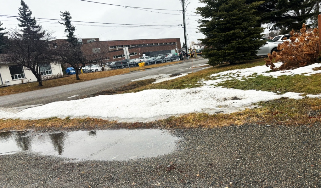
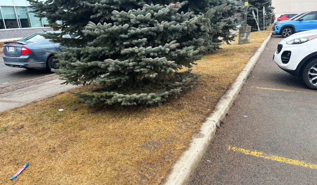 Experts say northeastern Ontario's major cities had their warmest winter on record – Timmins, North Bay, Sudbury. Sudbury alone received about 30 per cent less snow. (Darren MacDonald/CTV news)
“As a comparison last year last winter from Nov. 20, 2022, through April 2023, we had 15 general callouts. In a typical winter season, we have about 16.”
Overall, Rocca said the city received about 30 per cent less snow this year than average.
“I don't think at any point we could say there was you know, a metre of snow out on the ground when you looked around the community,” he said.
A report headed to the city’s operation committee March 25 bears that out. Sudbury normally receives 38.4 cm if snow in November, this year we received 26.3 cm. The city usually receives 60 cm in December, but got just 16.3 this year.
January was closer to the norm with 74.9 cm, but in February we received about 20 cm less than normal, and March normally sees 34 cm, whereas we have received just 11.9 cm as of March 20.
Kehler said Canadian winters have been trending warmer in recent years, and this year that trend combined with El Nino.
“El Nino has been the big driver of the warm weather, but we're seeing that in Canada, our winters just generally have been getting warmer over time due to Climate Change,” he said.
 Experts say northeastern Ontario's major cities had their warmest winter on record – Timmins, North Bay, Sudbury. Sudbury alone received about 30 per cent less snow. (Darren MacDonald/CTV news)
Combined with El Nino
“So when you have El Nino on top of that background warming from Climate Change, that makes it even easier to break these records. And so that's some of what we've been seeing this winter.”
None of the local snow machine dealers we contacted were available for an interview, but Kehler said things are tough all over for snowmobiling this year.
“The west has been very dry for most of this winter,” he said. “We just saw winter storm (recently). That was actually the biggest one of the winter. But up until that point a lot of the Prairies definitely didn't have enough snow to snowmobile for large swathes of the winter.”
While warm winters tend to be dryer, and lead to more forest fires, Kehler said other trends offer some hope. As El Nino weakens, he said rain tends to increase.
“We're actually seeing that El Nino will probably weaken or disappear this summer,” he said.
“That could change weather patterns significantly. It's not uncommon that when an El Nino event is waning, we can start to see precipitation increase again. So I wouldn't say that we're guaranteed to have a bad wildfire season, but you would obviously like to see more precipitation.”
After the record-breaking wildfire season of 2023, the Ministry of Natural Resources said they are actively monitoring conditions in the forest.
“Observations in late January and February suggest that many of the weather stations in northern Ontario have recorded lower than normal overwinter precipitation,” the MNRF said.
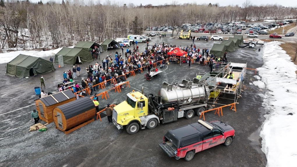 An overview of the the 2024 Sudbury Polar Plunge on March 2, 2024. Unlike past years, Ramsey Lake wasn't frozen over. (Facebook/Greater Sudbury Police Service)
Long-term trends
“However, there is still time for additional precipitation as we move into spring.”
Longer-term, Kehler said the warming trend will continue, along with more frequent extreme weather events.
“Well, I think warmer winters are pretty much baked in at this point,” he said.
“But the one thing I would point out is that with Climate Change, one impact that starting to become more and more evident is extremes. And so we're getting these extreme dry winters, but on the flip side, we may begin to see a lot of really extremely snowy winters, too, because the jet stream tends to get locked into certain patterns as it weakens from Climate Change.”
So the east coast will likely see more extreme snow storms, while other parts of the country, drought will become more common.
“So you'll get probably some good winters for snowmobiling and then somewhere it's just non-existent,” Kehler said.
“So the trend moving forward is do expect more extreme weather, you know on other end of the spectrum.”
Environment Canada meteorologist Geoff Coulson said one of the more notable aspects of winter this year is how consistently warm it has been.
“There's usually lots of variability -- cold snaps where we get Arctic air coming down,” Coulson said, or freezing rain events.
 Experts say northeastern Ontario's major cities had their warmest winter on record – Timmins, North Bay, Sudbury. Sudbury alone received about 30 per cent less snow. (Darren MacDonald/CTV news)
This winter is 'notably different'
“But this winter has been notably different in that regard, where the mild trend has been consistent through the three months --December January and February.”
This has been one of the more powerful El Nino effects, Coulson said, and it combined with warming trends from Climate Change.
“(For) much of this winter, we've been pulling in more Pacific air masses coming in from Washington State across the northern parts of the U.S., the southern prairies and not really tapping into that really, really cold air up around the Arctic Circle,” he said.
This spring could be trending wetter, Coulson agreed, something he said would help address “the moisture deficit” that started in November.
As far as what to expect, Coulson warned that winter weather could rebound.
“Even though the models are indicating this overall trend to be milder than normal, we still think there's potential for a lot of winter left in the northeast,” he said.
“As we’re heading to April, there’s still lots of potential for some of that cold air to filter down and mix in with these systems and give winter like conditions through the remainder of this month and even into the first part of April. So there's hope for more snowmobiling perhaps at some point.”
- Download our app to get local alerts on your device
- Get the latest local updates right to your inbox
One effect of the warm weather could be an early start to the road construction season.
“I think everyone's ramping up ready to go,” Rocca said.
“We (may be able) get out and start doing some of those more summer activities -- whether it's road construction, line painting, street sweeping -- a little bit earlier than we have in past years.”


CTVNews.ca Top Stories

More than 115 cases of eye damage reported in Ontario after solar eclipse
More than 115 people who viewed the solar eclipse in Ontario earlier this month experienced eye damage after the event, according to eye doctors in the province.
Toxic testing standoff: Family leaves house over air quality
A Sherwood Park family says their new house is uninhabitable. The McNaughton's say they were forced to leave the house after living there for only a week because contaminants inside made it difficult to breathe.
Decoy bear used to catch man who illegally killed a grizzly, B.C. conservation officers say
A man has been handed a lengthy hunting ban and fined thousands of dollars for illegally killing a grizzly bear, B.C. conservation officers say.
B.C. seeks ban on public drug use, dialing back decriminalization
The B.C. NDP has asked the federal government to recriminalize public drug use, marking a major shift in the province's approach to addressing the deadly overdose crisis.
OPP responds to apparent video of officer supporting anti-Trudeau government protestors
The Ontario Provincial Police (OPP) says it's investigating an interaction between a uniformed officer and anti-Trudeau government protestors after a video circulated on social media.
An emergency slide falls off a Delta Air Lines plane, forcing pilots to return to JFK in New York
An emergency slide fell off a Delta Air Lines jetliner shortly after takeoff Friday from New York, and pilots who felt a vibration in the plane circled back to land safely at JFK Airport.
Sophie Gregoire Trudeau on navigating post-political life, co-parenting and freedom
Sophie Gregoire Trudeau says there is 'still so much love' between her and Prime Minister Justin Trudeau, as they navigate their post-separation relationship co-parenting their three children.
Last letters of pioneering climber who died on Everest reveal dark side of mountaineering
George Mallory is renowned for being one of the first British mountaineers to attempt to scale the dizzying heights of Mount Everest during the 1920s. Nearly a century later, newly digitized letters shed light on Mallory’s hopes and fears about ascending Everest.
Loud boom in Hamilton caused by propane tank, police say
A loud explosion was heard across Hamilton on Friday after a propane tank was accidentally destroyed and detonated at a local scrap metal yard, police say.
Shopping Trends
The Shopping Trends team is independent of the journalists at CTV News. We may earn a commission when you use our links to shop. Read about us.


Barrie
-

One person killed in highway 400 crash in Innisfil
One person killed in multi-vehicle crash in Innisfil on Friday.
-
Gateway Casinos considers relocating from Innisfil venue
With its Innisfil location’s lease set to expire within the next five years, Gateway Casinos is eyeing a plan to move.
-
OPP responds to apparent video of officer supporting anti-Trudeau government protestors
The Ontario Provincial Police (OPP) says it's investigating an interaction between a uniformed officer and anti-Trudeau government protestors after a video circulated on social media.
Toronto
-
More than 115 cases of eye damage reported in Ontario after solar eclipse
More than 115 people who viewed the solar eclipse in Ontario earlier this month experienced eye damage after the event, according to eye doctors in the province.
-
Loud boom in Hamilton caused by propane tank, police say
A loud explosion was heard across Hamilton on Friday after a propane tank was accidentally destroyed and detonated at a local scrap metal yard, police say.
-
'Extremely traumatizing:' Boy, 11, struck by transport truck in Etobicoke
An 11-year-old boy struck by a transport truck in Etobicoke on Friday morning suffered critical injuries and is receiving treatment at a Toronto trauma centre, police say.
Ottawa
-

Trucker from Newfoundland missing in eastern Ontario
Ontario Provincial Police are asking for the public's help in locating a missing man from Newfoundland who disappeared in eastern Ontario.
-
'Too young to have breast cancer': Rates among young Canadian women rising
Breast cancer rates are rising in Canada among women in their 20s, 30s and 40s, according to research by the University of Ottawa (uOttawa).
-
Queen’s University names award-winning journalist Shelagh Rogers as next chancellor
Queen’s University says renowned Canadian broadcaster and alumna, Shelagh Rogers will serve as its 16th chancellor starting July 1.
Kitchener
-

Delays in Queen Victoria statue consultation have become 'disrespectful,' say Kitchener Indigenous community leaders
More than a year has passed since the City of Kitchener announced it was pausing community consultations on the future of the Queen Victoria statue in Victoria Park, and there is still no timeline for a resumption of the process.
-
250 Frederick Street ownership tied to alleged reno-victions in London, Hamilton
An investor with ties to apartment buildings across Ontario appears to be connected to 250 Frederick Street in Kitchener.
-
About 10 companies interested in Wilmot land, says Minister of Economic Investment
Ontario’s Minister of Economic Investment, Job Creation and Trade says a number of companies have shown interest in a tract of land the Region of Waterloo is trying to assemble in Wilmot Township.
London
-
Increased police presence in Tillsonburg
Police said they were called to a weapons-related incident on Morning Glory Drive around 1:30 p.m. Friday.
-
Pilot project sees Londoners in apartments and condos join green bin organic waste program
Three months after the launch of curbside green bin collection for homeowners, a pilot project will analyze expanding the program to include medium to high-density apartments and condominiums.
-
Portion of Highway 401 reopens following fatal crash
A fatal crash in Thames Centre closed down a portion of Highway 401 westbound. Around 2:15 a.m., first responders were called to westbound lanes of the highway between Culloden and Putnam Roads for a two-vehicle crash.
Windsor
-

NFL Draft: Windsor welcomes as Detroit overflows with fans
All the excitement of the NFL Draft has officially descended upon Detroit, with Windsor welcoming the spillover.
-
Julien’s House opens new Nick Dyer Clubhouse to offer peer-to-peer grief support
A ribbon cutting to celebrate the opening of a new grief support centre on Baseline Road in Windsor marked a bittersweet moment for many at Julien’s House Friday morning.
-
Windsor police seize $120,000 in drugs
Windsor police have arrested two people after seizing $120,000 in illegal drugs.
Montreal
-

'Do I ghost her again?': Quebec minister's office ignores questions on housing as a human right
The office of Quebec Housing Minister France-Élaine Duranceau prefers to openly ignore journalists' requests.
-
Taylor Swift dons Montreal designer's dress in 'Fortnight' video
A pair of Montreal designers' work has now been viewed over 41 million times. Taylor Swift dons a Victorian throwback black gown in her latest music video, 'Fortnight', designed by UNTTLD due Simon Belanger and Jose Manuel Saint-Jacques.
-
Truck driver dies in workplace accident at Port of Montreal
Officials with Quebec's workplace safety board were sent to the Port of Montreal on Friday after a truck driver was killed on the job.
Winnipeg
-

Avs rally for 6-2 win over Jets in Game 3
Nathan MacKinnon and Valeri Nichushkin scored on the power play during a five-goal, third-period outburst and the Colorado Avalanche rallied for a 6-2 victory over the Winnipeg Jets in Game 3 on Friday night.
-
'All these families are now scrambling': Gimli parents concerned about policy changes to child care
Parents in Gimli who rely on child care before and after school are sounding the alarm over policy changes coming in September.
-
Dishing out history: A look back at defunct restaurants in Winnipeg
Take an illustrated look back at the culinary history of Winnipeg.
Atlantic
-

First court appearance for boy and girl charged in death of Halifax 16-year-old
A girl and a boy, both 14 years old, made their first appearance today in a Halifax courtroom, where they each face a second-degree murder charge in the stabbing death of a 16-year-old high school student.
-
Cape Breton police find dead body in woods
Cape Breton Regional Police found a dead body in Sydney, N.S., Thursday evening.
-
Community steps up to support popular chef during cancer battle
A popular chef, who is fighting a battle against an aggressive form of cancer, is getting support from her community.
N.L.
-

Voice of 'Hockey Night in Canada' Bob Cole never considered moving out of St. John's
Legendary sportscaster Bob Cole was a Newfoundlander through and through, and his daughter says his connection to the province was 'everything' to him.
-
Cenovus fined $2.5 million for biggest oil spill in Newfoundland and Labrador history
Cenovus Energy has been ordered to pay a $2.5-million fine for its role in the largest offshore oil spill ever recorded in Newfoundland and Labrador.
-
Canada recognizes housing as a human right. Few provinces have followed suit
As more Canadians find themselves struggling to afford or find housing, the country's smallest province is the only one that can point to legislation recognizing housing as a human right.
Calgary
-

Stabbing at Calgary Value Village under investigation by police
Calgary police took two people into custody on Friday after a stabbing in the community of Haysboro.
-
'It's been a wonderful ride': Reunited 'X-Men' cartoon voice cast excited to meet fans new and old at Calgary Expo
If you've spent any amount of time scrolling TikTok at 3 a.m. (it's OK -- we all have), you probably know the meme...
-
Warmer, windy Saturday ahead for Calgary
It will warm up tomorrow, but it will also be gusty at times.
Edmonton
-

Cat who jumped from burning balcony will recover: management company
A cat that jumped from the balcony of a burning building in downtown Edmonton on Thursday afternoon will make a full recovery, building officials say.
-
'So damn undemocratic': Edmonton mayor reacts to legislation granting province power to fire councillors or veto local bylaws
A bill that would empower the Alberta government to remove elected municipal officials or strike down local bylaws is an "attack on local democracy," says the capital city's mayor.
-
DonAir force takes over at Oilers playoff games
As if a 4-0 Edmonton Oilers lead in Game 1 of their playoff series with the Los Angeles Kings wasn't good enough, what was announced at Rogers Place during the next TV timeout nearly blew the roof off the downtown arena.
Regina
-

Man charged with murder, victim identified in southeast Sask. homicide case
RCMP have identified 28-year-old Brianna Hayes from Oxbow, Sask. as the victim in an ongoing homicide investigation in the province’s southeast. As a result, police have charged 24-year-old Taylor Japp, also from Oxbow with second degree murder, an RCMP news release said.
-
Lego therapy program expands through Yorkton SaskAbilities
Youth in Yorkton can now access a new Lego Therapy program in their community through SaskAbilities.
-
Regina police officer injured after another officer's gun accidentally fired
A Regina police officer was injured after another officer's gun was accidentally fired while conducting a search warrant early Friday morning.
Saskatoon
-

Saskatchewan's $90M social services initiative underway
Over six months after Saskatchewan's government announced a significant $90 million investment in social services, the initiative is reportedly making progress.
-
Saskatoon police investigating after body found at recycling facility
The Saskatoon Police Service (SPS) and Saskatchewan Coroners Service are investigating after a woman’s body was found at a recycling facility Friday morning.
-
Four people arrested after attempted armed robbery in Saskatoon
Four people, including two teen girls, were arrested and charged after an attempted armed robbery on Thursday evening.
Vancouver
-

Canucks defeat Predators in Game 3, take 2-1 series lead
J.T. Miller had a goal and assist and the Vancouver Canucks edged the Nashville Predators 2-1 to re-take the lead in their first-round playoff series.
-
Calls for changes to Hwy. 5 after CN Rail worker killed in head-on collision
The 36-year-old killed on Highway 5 this week has been identified as Juver Balmore, a husband and father of three young children who worked for CN Rail.
-
1 man in custody after suspicious fire at Surrey townhome, RCMP say
A fire that displaced three families from a townhouse complex in Surrey's Newton neighbourhood Friday afternoon is considered suspicious, local Mounties say.
Vancouver Island
-

B.C. seeks ban on public drug use, dialing back decriminalization
The B.C. NDP has asked the federal government to recriminalize public drug use, marking a major shift in the province's approach to addressing the deadly overdose crisis.
-
Saanich to consider amalgamating fire department with Victoria, Esquimalt, Oak Bay
Saanich council will be discussing a report Monday prepared by Saanich Fire Chief Michael Kaye on the merits of amalgamating the fire departments of Victoria, Oak Bay, Esquimalt and Saanich.
-
B.C. composer with debilitating condition realizes dream of scoring movie
When Art Kinarthy embarked upon this quest, he never could have imagined where it would ultimately lead.


