Another storm tracking towards northern Ont., bringing mix of ice, rain and snow
Environment Canada issued weather alerts across northern Ontario on Monday morning as another storm approaches the region bringing rain, freezing rain and snow.
The storm is expected to start Tuesday and tape off by Wednesday evening.
Here is a look at what is expected in each community.
FREEZING RAIN
Freezing rain is expected to begin Tuesday evening along the Highway 17 corridor from the Sault Ste. Marie area to Mattawa, including Greater Sudbury.
Ice accumulation of up to 5 millimetres is possible before it turns to rain Wednesday bringing 20 to 40 millimetres, Environment Canada said.
"The rain is expected to taper off Wednesday night," the weather alert said. "Localized flooding in low-lying areas is possible.
- Download our app to get local alerts on your device
- Get the latest local updates right to your inbox
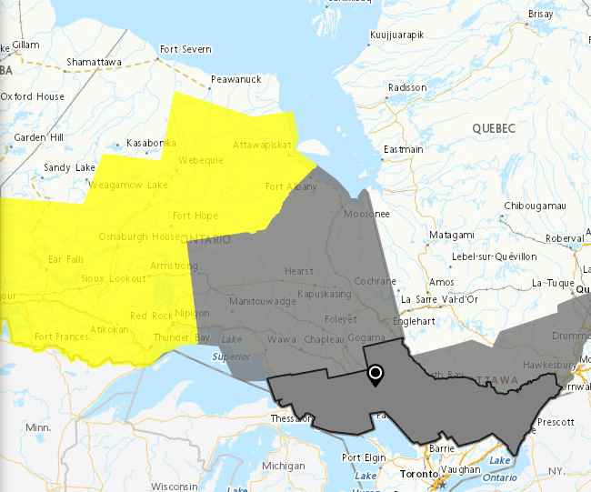 Freezing rain expected Tuesday, Wednesday from Sault Ste. Marie to Quebec. (Environment Canada weather alert map)
SNOW AND ICE PELLETS
Further north, along the Highway 11 and 101 corridors from the Quebec border to the Marathon and Geraldton areas, Tuesday evening is expected to bring snow or ice pellets which will turn to freezing rain and then rain Wednesday.
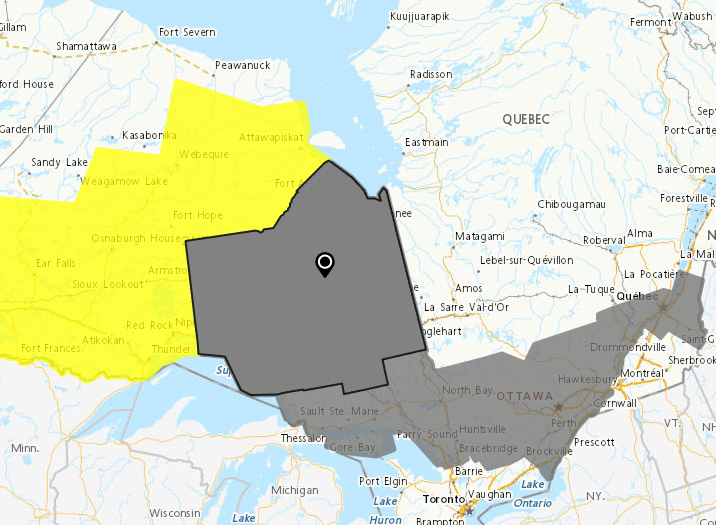 Snow, ice pellets before freezing rain and rain. (Environment Canada weather alert map)
This area could see five to 10 centimetres of snow and ice accumulation and strong wind gusts up to 60 km/h.
"An intensifying Colorado Low is expected to track over northwestern Ontario on Wednesday," Environment Canada said.
"Some areas may see the precipitation then change to rain later Wednesday while others could see a change back to snow. Uncertainty remains regarding the track of this system which could change the location of the freezing rain and snowfall amounts."
WINTER STORM WATCH
Meanwhile, the storm will begin with snow in northwestern Ontario on Tuesday afternoon with accumulation between 15 to 25 cm possible, Environment Canada said.
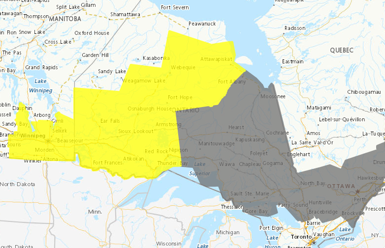 Winter storm watch for communities in yellow, where 15 to 25 cm of snow is expected. (Environment Canada weather alert map)
"Snow ahead of this system is forecast to move into northwestern Ontario Tuesday afternoon or evening before tapering off Thursday morning," the weather alert said.
"The snow may be mixed with ice pellets or freezing rain at times for areas near Lake Superior, potentially lowering snowfall amounts. In addition, winds gusting to 60 km/h may produce poor visibilities in local blowing snow in exposed areas."
Communities under winter storm watch stretch east from the Manitoba border to just past Beardmore and Nipigon in the east and Pikangikum and Fort Hope in the north.


CTVNews.ca Top Stories

From essential goods to common stocking stuffers, Trudeau offering Canadians temporary tax relief
Canadians will soon receive a temporary tax break on several items, along with a one-time $250 rebate, Prime Minister Justin Trudeau announced Thursday.
She thought her children just had a cough or fever. A mother shares sons' experience with walking pneumonia
A mother shares with CTVNews.ca her family's health scare as medical experts say cases of the disease and other respiratory illnesses have surged, filling up emergency departments nationwide.
Putin says Russia attacked Ukraine with a new missile that he claims the West can't stop
Russian President Vladimir Putin announced Thursday that Moscow has tested a new intermediate-range missile in a strike on Ukraine, and he warned that it could use the weapon against countries that have allowed Kyiv to use their missiles to strike Russia.
Service Canada holding back 85K passports amid Canada Post mail strike
Approximately 85,000 new passports are being held back by Service Canada, which stopped mailing them out a week before the nationwide Canada Post strike.
Taylor Swift's motorcade spotted along Toronto's Gardiner Expressway
Taylor Swift is officially back in Toronto for round two. The popstar princess's motorcade was seen driving along the Gardiner Expressway on Thursday afternoon, making its way to the downtown core ahead of night four of ‘The Eras Tour’ at the Rogers Centre.
Manitoba RCMP issue Canada-wide warrant for Ontario semi-driver charged in deadly crash
Manitoba RCMP have issued a Canada-wide arrest warrant for the semi-driver involved in a crash that killed an eight-year-old girl and her mother.
Here's a list of items that will be GST/HST-free over the holidays
Canadians won’t have to pay GST on a selection of items this holiday season, the prime minister vowed on Thursday.
Mother charged after infant dies in midtown Toronto: police
The mother of an infant who died after being found at an apartment building in midtown Toronto on Wednesday has been charged with failing to provide the necessaries of life.
B.C. man who sold Porsche to scammers shares cautionary tale
A man from B.C.’s Lower Mainland who was scammed while selling his Porsche Cayenne online is sharing his cautionary tale – while calling for increased protections from the government.
Shopping Trends
The Shopping Trends team is independent of the journalists at CTV News. We may earn a commission when you use our links to shop. Read about us.


Barrie
-

How to avoid the number one cause of lung cancer in non-smokers, according to health experts
Radon is the number one cause of lung cancer in non-smokers in Canada, according to Grey Bruce Public Health Unit.
-
OPP launch 'Project Atlas' to curb crypto scams
With the rise of cryptocurrency investment scams, the OPP have launched ‘Project Atlas’ this week, an initiative to clamp down on investment fraud.
-
Suspect charged for series of vehicle break-ins, credit card thefts
A Midland resident is facing numerous charges for allegedly breaking into numerous vehicles in Midland and using stolen cards.
Toronto
-

Taylor Swift's motorcade spotted along Toronto's Gardiner Expressway
Taylor Swift is officially back in Toronto for round two. The popstar princess's motorcade was seen driving along the Gardiner Expressway on Thursday afternoon, making its way to the downtown core ahead of night four of ‘The Eras Tour’ at the Rogers Centre.
-
2 people arrested, 3rd suspect still at large in connection with fatal Brampton shooting
Two people have been arrested and another suspect remains at large in connection with a fatal shooting in Brampton earlier this month.
-
Mother charged after infant dies in midtown Toronto: police
The mother of an infant who died after being found at an apartment building in midtown Toronto on Wednesday has been charged with failing to provide the necessaries of life.
Ottawa
-

uOttawa to reconsider participation in U-Pass if city increases student fares, student union says
The student union at the University of Ottawa says it will consider pulling its participation from the U-Pass, which provides discounted transit fares for students, if the city goes forward with hiking student transit fees and violating the program’s contract.
-
2 arrested during Greenpeace protest outside Stornoway residence in Ottawa
Two people have been arrested following a protest outside Stornoway, the official residence of Canada's leader of the Opposition.
-
McDonald's Canada CEO not ruling out a return to the ByWard Market
McDonald's Canada says it has not closed the door on a return to Ottawa's downtown.
Kitchener
-

FunGuyz says it's closing all 30 of its magic mushroom stores in Ontario
FunGuyz, which calls itself the biggest magic mushroom dispensary in Canada, says it's shutting down all 30 of its Ontario locations.
-
Grand River Transit LRT involved in Kitchener crash
A busy Kitchener street could be closed for several hours after a crash involving a Grand River Transit vehicle.
-
Fight between rival motorcycle gangs in Cambridge leads to five arrests, more than a dozen charges
A fight between rival outlaw motorcycle gangs has led to multiple arrests, more than a dozen charges and the seizure of 17 firearms.
London
-

'We asked.. No answer': Western students continue to press for a divestment strategy
Concerned staff and students continue to look for progress on divestment issues by Western University administration.
-
London man arrested after attempting to break into a home, threatening residents
Police say that on Thursday, November 21 between the hours of 1:30 a.m., and 4:30 a.m. the suspect came and went from a residence on Conway Drive.
-
From essential goods to common stocking stuffers, Trudeau offering Canadians temporary tax relief
Canadians will soon receive a temporary tax break on several items, along with a one-time $250 rebate, Prime Minister Justin Trudeau announced Thursday.
Windsor
-

Woman sought following serious assault in west Windsor
Windsor police are asking for the public’s help identifying a suspect wanted in connection to an alleged serious assault that happened this past summer.
-
Service Canada holding back 85K passports amid Canada Post mail strike
Approximately 85,000 new passports are being held back by Service Canada, which stopped mailing them out a week before the nationwide Canada Post strike.
-
Leamington's Colton Smith leading the path after college hockey eligibility changes
A recent ruling by the NCAA allowing major junior hockey players to maintain college eligibility is starting to change the hockey landscape.
Montreal
-

Pro-Palestinian protesters gathered outside Concordia University amid Quebec-wide boycotts
The lobby of Concordia University’s Hall Building was flooded with pro-Palestinian protesters Thursday as others gathered and chanted outside the campus as part of Quebec-wide solidarity strikes.
-
Transit and taxes: mixed reactions to Quebec budget
There was a mixed reaction to the Quebec government's fall fiscal update on Thursday as the province announced billions of dollars in new spending.
-
Quebec fiscal update: $2.1B in new spending, axes tax credit for older workers
Quebec Finance Minister Eric Girard tabled an economic update on Thursday with $2.1 billion in new spending over five years amid what he described as a stronger-than-expected recovery from last year's economic slowdown.
Winnipeg
-
 BREAKING
BREAKING Sio Silica plans to try again with controversial project in Manitoba
Sio Silica is planning to try again with a controversial mining project in the same spot using the same method that the province rejected less than a year ago, but this time with more community engagement.
-
Manitoba RCMP issue Canada-wide warrant for Ontario semi-driver charged in deadly crash
Manitoba RCMP have issued a Canada-wide arrest warrant for the semi-driver involved in a crash that killed an eight-year-old girl and her mother.
-
Mayor Gillingham and Premier Kinew to face off in friendly hockey game for Winnipeg 150
The Manitoba premier is set to face off against Winnipeg's mayor on Nov. 30 to mark Winnipeg's 150th anniversary.
Atlantic
-
From essential goods to common stocking stuffers, Trudeau offering Canadians temporary tax relief
Canadians will soon receive a temporary tax break on several items, along with a one-time $250 rebate, Prime Minister Justin Trudeau announced Thursday.
-
'This is cold': P.E.I. mother upset over decision to remove late daughter's photos from school memorial wall
A high school on Prince Edward Island is removing pictures of its late students from a memorial wall – a decision that has upset one mother whose daughter attended the school.
-
Fredericton man facing several charges after five people taken hostage
A 36-year-old Fredericton man is facing several charges, including forcible confinement, after police say five people were taken hostage in the city.
N.L.
-

As N.L. firm pivots, scientists say Canada's green hydrogen dreams are far-fetched
A Newfoundland energy company's embrace of data centres is raising doubts about eastern Canadian hopes of harnessing the region's howling winds to supply Germany with power from green hydrogen.
-
Canadian leads group pushing Vatican for zero-tolerance policy on abuse by clergy
An international group led by a Canadian is in Rome this week to push the Catholic Church to adopt a zero-tolerance policy on abuse by clergy.
-
Newfoundland wind-to-hydrogen company eyes data centre as international market lags
A company hoping to build a multi-billion-dollar wind-to-hydrogen project in western Newfoundland is eyeing other options as Canada's plans to supply Europe with green energy have not yet materialized.
Calgary
-

Calgary Fire Department responding to explosion in Mahogany
Calgary Fire Department is responding to an explosion at a six-plex in the city's southeast.
-
Police probe possible connection between Calgary house fire and Bitcoin notes
Calgary police are seeking information in relation to a Tuesday fire in Hillhurst they believe was deliberately set and notes left in the area demanding Bitcoin.
-
Six shots fired after Calgary road rage incident, police seek dash-cam footage
Calgary police are looking for dash-cam footage as they investigate a shooting in the community of Cityscape believed to be the result of road rage.
Edmonton
-

Alberta pitches new rules for auto insurance, including rate hikes, no-fault claims
The Alberta government is making changes to auto insurance, including rate hikes and switching to a predominantly no-fault claims model.
-
Alberta forecasts $4.6B surplus in budget update, but braces for uncertainty
Alberta is forecasting a $4.6-billion surplus for this fiscal year, but Finance Minister Nate Horner says "mounting pressures" threaten to soon put the province in the red.
-
Oilers without Nurse, Arvidsson, Hyman in lineup against visiting Wild
A trio of top-line Edmonton Oilers will be missing from action Thursday.
Regina
-

Contractor fatally injured while on the job at Regina's Evraz plant
Evraz North America says an investigation is underway after a contractor was fatally injured while on the job in Regina on Nov. 19.
-
'I'll always be a Pat': Regina Pats trade captain Tanner Howe to Calgary
The Regina Pats have announced a blockbuster trade Thursday that sees captain Tanner Howe on his way to Calgary to play for the Hitmen as the team continues rebuilding for the future.
-
Jeremy O'Day speaks on wins, losses and Riders' overall performance in 2024
The Grey Cup Champion has officially been crowned for the 2024 season and once again it did not go to the Saskatchewan Roughriders. On Thursday, General Manager, Jeremy O'Day, spoke to media to break down another year.
Saskatoon
-

Saskatoon's first female mayor sworn in
After being sworn in Wednesday night alongside a mix of new and returning city councillors, Cynthia Block becomes the first female mayor of Saskatoon.
-
Sask. tuxedo business closes stores across the province
A Saskatchewan tuxedo business says struggles with inflation and operating costs have caused it close stores across the province.
-
Alberta non-profit Mustard Seed to run Saskatoon's Lighthouse
Alberta-based non-profit the Mustard Seed is stepping up to run Saskatoon's Lighthouse.
Vancouver
-

B.C. man sentenced to probation for social media stunt
A man who drove a car into B.C.'s Burrard Inlet in a livestreamed social media stunt has been sentenced to one year of probation and will not have a criminal record if he complies with court-ordered conditions.
-
Video shows octopus 'hanging on for dear life' during bomb cyclone off B.C. coast
Humans weren’t the only ones who struggled through the bomb cyclone that formed off the B.C. coast this week, bringing intense winds and choppy seas.
-
Man stabbed by stranger in Surrey’s Newtown area, RCMP say
Authorities are investigating after a man was reportedly stabbed by a stranger in Surrey’s Newtown area this week.
Vancouver Island
-

Major crime investigators reviewing death of Victoria teen, which coroner reclassified as homicide
Vancouver Island’s major crime unit is investigating the case of a Victoria teenager whose death was initially ruled an accidental overdose, but has since been reclassified by coroners as a homicide.
-
1 dead after Nanaimo house fire, RCMP say
One person is dead after a fire that destroyed a home in Nanaimo's south end Wednesday morning.
-
Another windstorm headed to B.C.’s South Coast Friday, Environment Canada says
Another fall storm is forecast to bring high winds to B.C.’s South Coast on Friday, Environment Canada says.


